39 Manawa Road (Remuera’s Century-Old Homes Project)
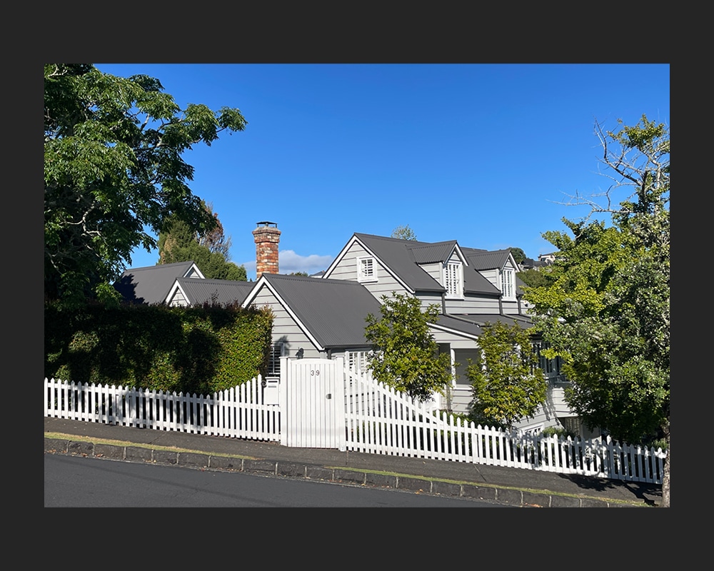
Figure 1: The cottage at 39 Manawa Road, showing parts of its north and east elevations (C. O’Neil, March 2025).
First built around 1860, the multi-gabled cottage at 39 Manawa Road is one of only a small number of mid-nineteenth century dwellings surviving in Remuera. Although extended over time, the place is a tangible reminder of the suburb’s early settlement, social history, and way of life. It even has links with one of Remuera’s earliest schools.
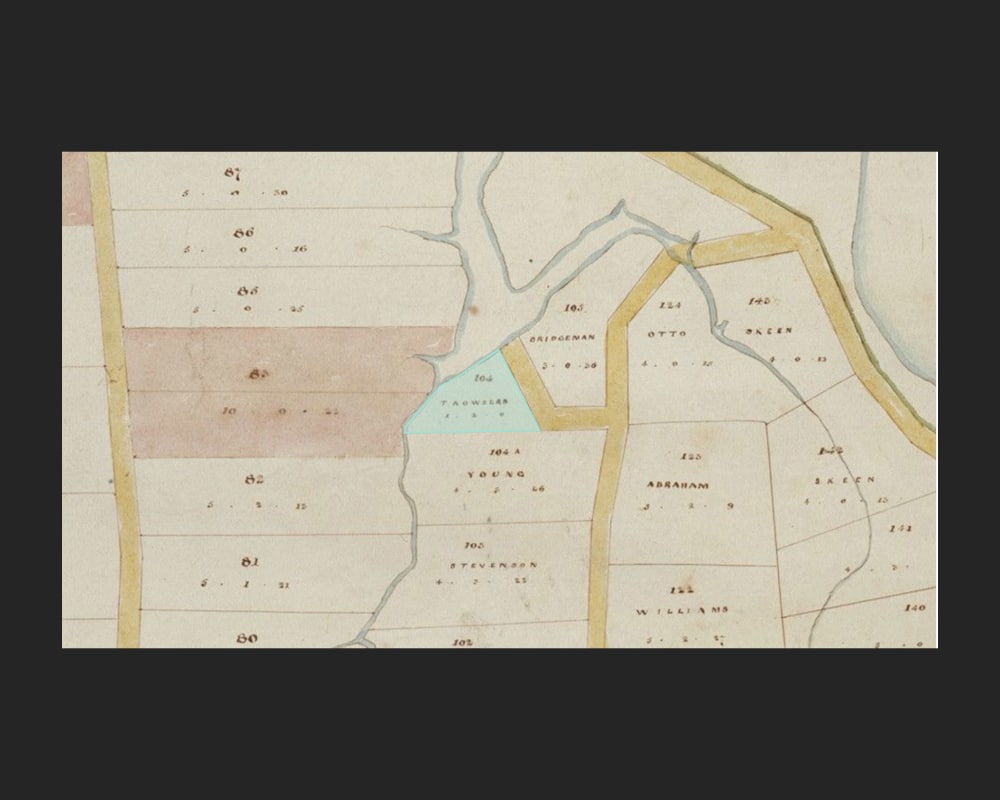
Figure 2: Extract from a map showing allotments at Orakei, Section 16 Suburbs of Auckland, 1860. At that time, original Allotment 104 (highlighted) was in the ownership of Hohepa Tarautete – Joseph ‘Trowsers’ (Auckland Libraries Heritage Collections Map 4204).
Early European land ownership
The dwelling at 39 Manawa Road was built on part of original Allotment 104 of Section 16, Suburbs of Auckland.[1] Measuring just over an acre-and-a-half, the allotment was a
triangular-shaped parcel of land situated between present-day Orakei Road and Victoria Avenue. Access to the site was made via a track off Orakei Road or via the tidal creek that ran alongside the property.
Allotment 104 was originally granted to Hohepa (also known as Joseph) Tarautete in 1856, when much of the land around present-day Orakei, Upland and Benson roads was made available by the Crown at public auction (Figure 2).[2] Described on the land register as an ‘aboriginal native’ of Remuera, Tarautete belonged to the Ngā Oho hapū of Ngāti Whatua of Orakei.[3] He was also known as Joseph ‘Trousers’ (or ‘Trowsers’), the English translation of Tarautete, which it has been suggested may have derived from his wearing Pakeha style trousers.[4] Educated at a mission school, Tarautete was reputedly a lay preacher who also collected shipping dues from Māori and Pakeha traders on the Waipapa Reserve at Mechanics Bay.[5] A year after acquiring Allotment 104 for £52, he secured the Crown grant for a neighbouring five acres of land that fronted present-day Victoria Avenue that later became a primary school reserve.[6] By 1860, a cottage had been built on Allotment 104.[7]
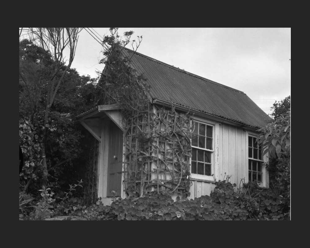
Figure 3: The small board and batten schoolroom that was possbily one of the first dame schools in Remuera. Believed to date from at least the 1850s, it stood at present-day 39 Manawa Road until 1978 (Auckland Libraries Heritage Collections, reference unavailable, https://digitalnz.org/records/29953261/38-manawa-road-remuera)
Māori school / Dame school
According to historian Alan La Roche, Tarautete operated a Māori school near the Orakei Basin.[8] It is possible that this was the one-roomed, kauri board and batten building that stood on the property for well over a century (Figure 3). Probably built from a prefabricated ‘kitset’, the school was considered large enough for around 10 to 12 children.[9] Although the date of construction is unknown, it is possible that the modest building was in place before 1857. At that time, a Mrs Mary Young was living on nearby Orakei Road and it is thought that she may have ran a “small school down towards the bottom of the hill” for her daughters and a few other children, which may have been the building on Tarautete’s property.[10]
Such small schools were not uncommon during the early years of European settlement in Auckland and before the passing of the Compulsory Education Act in 1878.[11] During this time, many young children were taught by a local woman for a small fee, either in their own homes or in a building nearby.[12] The term was also used for those schools who taught young ladies fine manners, painting, sewing and elocution lessons.[13]
Other early owners
In 1862, Tarautete sold Allotment 104 to Remuera settler, John Smith Williams for £80.[14] By 1868, the property was valued at £120, suggesting improvements had been made.[15] That same year, Williams’ wife, Mary Ann(e), applied to the police court for protection against her husband, whom she charged with desertion.[16] She claimed that for the past seven months, her husband had not provided any support and she desired protection for her own property. She had since supported herself by keeping a school (presumably the school on the property) and taking in boarders, while paying her husband £1 2s. per month for the rent of the cottage.[17]
In 1874, Williams sold the property occupied by the cottage and small school to Reuben Scarborough, a local farmer who had immigrated to New Zealand from England in 1863.[18] Scarborough already owned five acres of land fronting present-day Victoria Avenue, which he had purchased from Williams three years earlier.[19] There he ran dairy cattle and, as he prospered, built a substantial concrete house known as ‘Avoca’/’Ovoca’ (now demolished). He also went on to form ‘Reuben Scarborough & Sons’, a successful horse-bus business.[20]
In 1882, Scarborough subdivided Allotment 104 into two lots.[21] The northern lot, which measured around three-quarters of an acre and comprised the cottage and school, was purchased by farmer and ‘remittance man’, John Bishop.[22]
The Bishops
Hailing from the historic English village of Rolvenden in Kent, John Bishop, his wife, Kate, and their four children immigrated to New Zealand in 1860, travelling aboard the ship ‘Avon’.[23] They were joined by John’s adult son, also named John, from his first marriage.[24] Initially settling on a farm in New Plymouth, the Bishops later relocated to Auckland and owned 160 acres of land in the Waitakere Ranges.[25] Records suggest that the family may have been living in Remuera from as early as 1868, when John Bishop, a champion marksman, took out a license to shoot game.[26]
When the Bishops took up the northern part of Allotment 104 on present-day Manawa Road in 1882, it was the start of the family’s decades-long connection with the property. By this time, John and Kate had a further three children.[27] Over time, the road leading to the cottage and schoolroom, which was then little more than a track, became known as ‘Bishop’s Lane’, while the neighbouring creek that provided access to the property via the waterways, was named ‘Bishop’s Creek’.[28] One of their younger sons, Alfred (‘Fred’) Mynn Bishop, became a well-known local fisherman and would negotiate his boat up Bishop’s Creek to the family home.[29]
Following John Bishop’s death in 1902, Kate took ownership of the property.[30] Before her own death in 1908, she transferred the property to her two unmarried daughters, Kate Bishop (the younger) and Mary Morris Bishop.[31] For some time, Kate (the younger) had taught local children at the small school on the family’s property, and remained the school mistress until her sudden death in 1917.[32] Mary continued to live at the family cottage until her own death in 1929,when the property was transferred to her brother, Fred who lived there with his wife, Vera Gwendoline Aileen.[33]
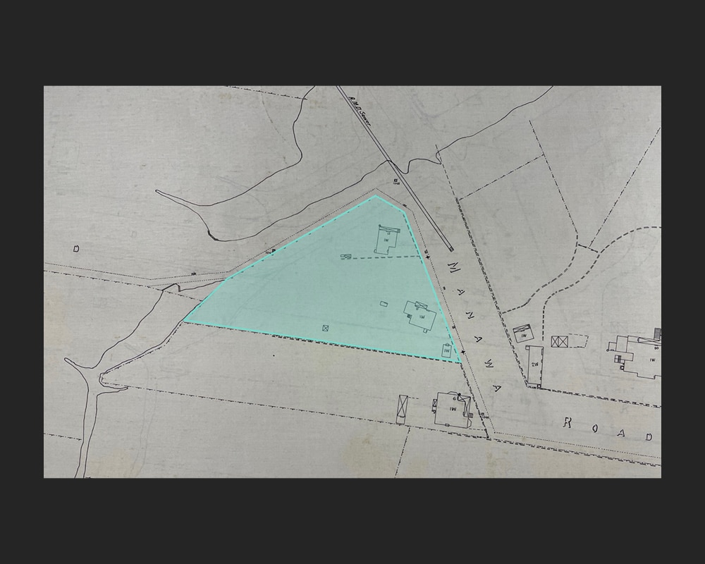
Figure 4: (Above) Extract of the 1908 City of Auckland Map, showing the northern part of original Allotment 104 (highlighted) and the three buildings located on the site during the early 1920s – the subject cottage and schoolroom in the southeast corner and the secondary cottage (now demolished) in the northern corner (ACC 001, City of Auckland Map, 1923, Auckland Council Archives).

Figure 5: (Left) Close-up of the map, showing the footprint of the cottage and the schoolroom on the site, both recorded as single-storey wooden structures.
The property
During the early decades of the twentieth century, the Bishop family property was recorded as a single-storey, twin-gable cottage, constructed of timber and iron and comprising five rooms and a verandah on its north elevation.[34] At this time, the old schoolroom was documented as a single-storey, wooden ‘shed’.[35] Also located at the northern corner of the property was a small, four-roomed dwelling situated on low-lying land near the creek. This secondary cottage was rented out by the family (Figure 4 and Figure 5).[36]
In 1917, neighbouring Allotment 83, which was located on the western side of the family property and just beyond Bishop’s Creek, was subdivided.[37] The subdivision comprised 27 residential lots that extended from Victoria Avenue in the west to Bishop’s Creek in the east. The newly-formed street was named Manawa Road.[38] By 1919, Bishop’s Lane on the eastern side of the creek was also named Manawa Road and was connected to the new subdivision.[39]
In 1933, a building permit was granted for a bathroom and scullery in the Bishop family’s main cottage. By the mid-twentieth century, the accommodation had expanded to include three bedrooms, a sitting room, a living room, and a kitchen.[40]

Figure 6: Showing the subdivision plan of the property split into three lots, dated 1953. Lot 2 (highlighted) was occupied by the cottage and schoolroom (DP 41312, LINZ records).
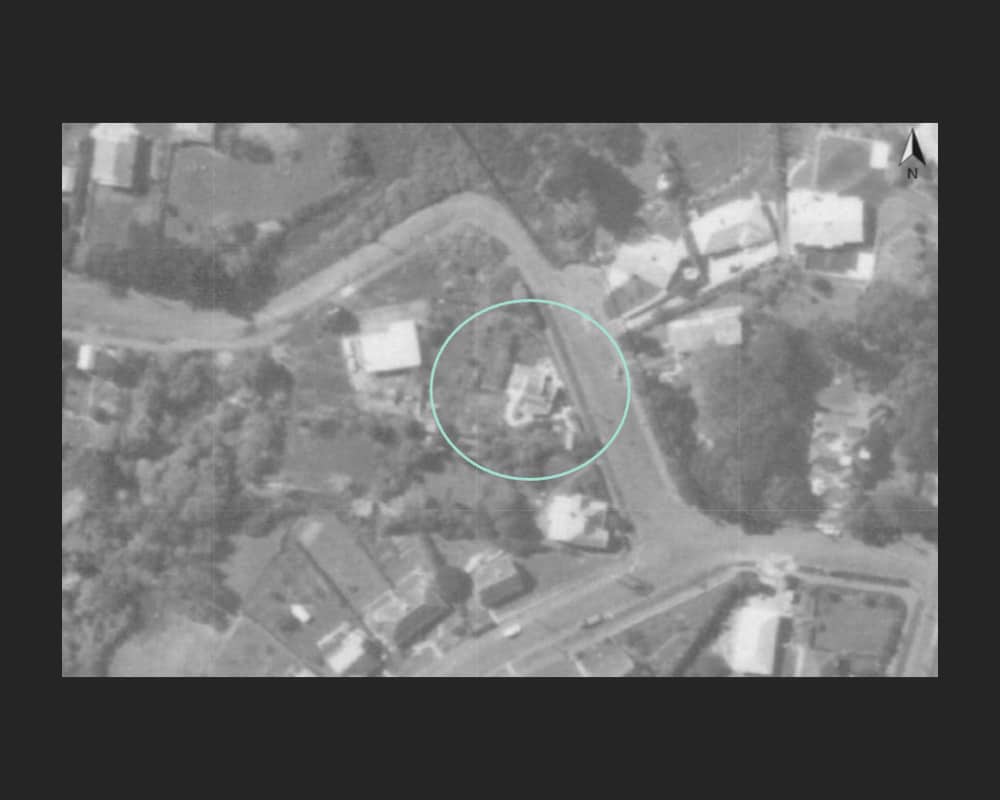
Figure 7: Showing the cottage and schoolroom at 39 Manawa Road within its immediate residential context on the west side of Manawa Road and to the south of Bishop’s Creek, 1959 (Auckland Council GeoMaps).

A painting of the cottage at 39 Manawa Road from the 1960s.
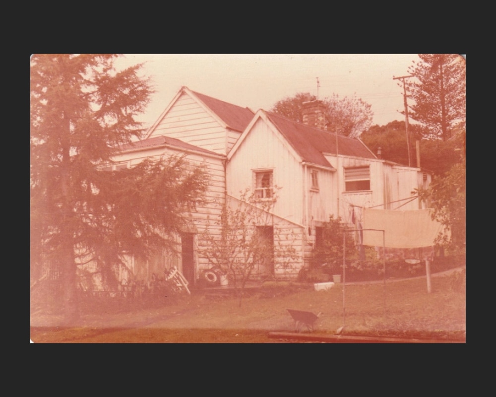
Figure 8: The cottage at 39 Manawa Road, viewed from roughly the west, photographed by Graham (Graeme) Craw possibly around the time the schoolroom was relocated to his Anawhata farm (Howick Historical Village records, P2021.57.03).
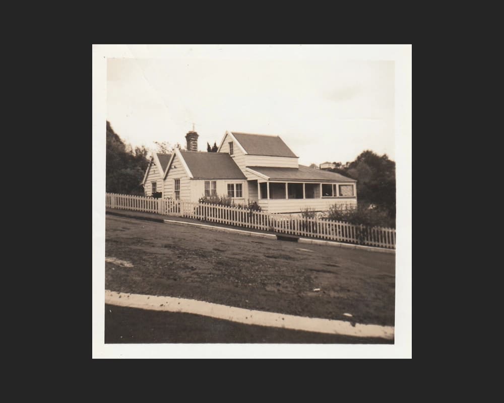
Figure 9: The cottage at 39 Manawa Road, photographed by Keith Cathie, possibly during his ownership in the 1970s (Howick Historical Village records, P2021.58.02).

Figure 10: The schoolroom at 39 Manawa Road with an unknown lady in the foreground, photographed by Keith Cathie, possibly during his ownership in the 1970s (Howick Historical Village records, P2021.58.03).
New owners and subdivision of property
Fred Bishop’s death in 1947 marked the end of the Bishop family’s 65-year ownership of the property at Manawa Road. That year, it was transferred to Auckland housekeeper, Gladys Murray.[41] In 1953, she subdivided the site into three lots (Figure 6).[42]
Lot 1 comprised the western portion of the property, which was heavily planted. The land was subsequently sold and, by 1959, a house (present-day 35 Manawa Road) had been built.[43] Lot 2 comprised the eastern portion of the property occupied by the main cottage and former schoolroom, which remained in Gladys Murray’s ownership (Figure 7).[44] Lot 3 comprised the northern portion of the site, including the small, secondary cottage. This lot was subsequently taken for roading purposes, resulting in the removal of the cottage and the creation of a street reserve.[45]
Gladys Murray retained ownership of the cottage and former schoolroom at 39 Manawa Road until 1975 when it was transferred to Oratia-based retiree, Keith Cathie (Figure 8, Figure 9 and Figure 10).[46]

Figure 11: The former schoolroom on Graeme Craw’s Anawhata farm, ready to be moved to the Howick Historical Village, photographed by Alan La Roche (Howick Historical Village records, P2021.61.04).
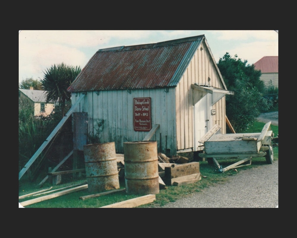
Figure 12: (Above) The former schoolroom being restored at Howick Historical Village, photographed by Alan La Roche on 24 May 1988 (Howick Historical Village records, P2021.61.14).

Figure 13: (Right) The official opening of the ‘Bishop’s Creek Dame School’ at Howick Historical Village on 6 May 1990, undertaken by historian, Alan La Roche (right) and Keith Cathie (left) who formerly owned 39 Manawa Road (Howick Historical Village records, P2021.62.01).
Relocation of the former schoolroom
In 1978, Keith Cathie gave the former schoolroom to Graeme Craw, a farmer, earth-moving contractor, and avid collector.[47] Graeme relocated the small building to his Anawhata farm on Auckland’s west coast (Figure 11). There, he had established an extensive collection of nineteenth and twentieth century vehicles, machinery, and memorabilia that went on to become part of the ‘Packard Motor Museum’.[48]
When Graeme Craw’s Anawhata property was sold in 1988, he donated the former schoolroom to then ‘Howick Colonial Village’, a living history museum established several years earlier.[49] In a poor state of repair, the old schoolroom was relocated to the Pakuranga museum site, and was restored by local farmer, Arthur White, and a team of volunteers of the Howick and District Historical Society (Figure 12).[50] Named ‘Bishop’s Creek Dame School’ in memory of its early location and use in Remuera, the old schoolroom was officially opened at the museum on 6 May 1990.[51]
Subsequent owners and changes
In 1979, after four years of ownership, Keith Cathie sold 39 Manawa Road to Auckland artist, Sally Gallagher and architectural draughtsman, Jansen Simpson.[52] The following year, works were carried out to the cottage, including internal modifications and the construction of a new deck.[53] At the time, the cottage was laid out over three floors, which included a double garage and laundry in the basement; a lounge, dining room, kitchen, two bedrooms and a bathroom on the ground floor; and two further rooms in the attic.[54] In 1992, the accommodation was extended further with the addition of a family room on the south elevation.[55]
In 2001, the property was subdivided into two lots.[56] Lot 1 was occupied by the cottage, while the vacant Lot 2 was subsequently sold and developed (present-day 37 Manawa Road). The cottage changed hands a number of times over the following two decades, and, by 2017, a swimming pool had been installed in the garden.[57]
Once a modest, twin-gable cottage, the dwelling at 39 Manawa Road has been extended and changed over time. Despite these changes, it remains a distinctive building within the streetscape and, at around 165 years old, is a valuable remnant of Remuera’s residential and social history.
Background
The Heritage Studio Limited has been commissioned by Remuera Heritage as part of their ‘Century-Old Homes’ campaign to undertake research and prepare a story that documents the history of 39 Manawa Road, which includes the colonial cottage that stands today and an old schoolroom that was relocated from the site some decades ago.
Research involved viewing online repositories such as DigitalNZ, Papers Past and Auckland Libraries resources; sourcing available information at Auckland Council Archives; and viewing deeds indexes, deposit plans, and certificates of title from Archives New Zealand and Land Information New Zealand. It is important to note that opportunities still exist to explore other avenues of research, which may yield more information.
A site visit was carried out on 5 March 2025, where the place was viewed from the public realm.
Subscribe to our newsletter to keep up to date.
[1] ‘Map shewing allotments at Orakei near Auckland, section sixteen of the suburbs of Auckland called Remuera’, 1860, Auckland Libraries Heritage Collections Map 4204; Winifred Macdonald, Recollections 1850-1920: A Sketch History of Early Remuera, Milnes of Remuera, 1984, 8.
[2] Deeds index 8A 128, Archives New Zealand; Winifred Macdonald, 1984, 30.
[3] Deeds register 10D 323, Archives New Zealand; Jenny Carlyon and Diana Morrow, A Fine Prospect: A History of Remuera, Meadowbank and St Johns, Random House, Auckland, 2011, 145; Alan La Roche, ‘Bishop’s Creek Dame School’, Auckland-Waikato Historical Journal, April 1990, No.56, 3.
[4] Page 1 Advertisements Column 3, Daily Southern Cross, Volume XXI, Issue 2568, 11 October 1865, Papers Past; Jenny Carlyon and Diana Morrow, 2011, 145; Alan La Roche, April 1990, 3.
[5] Jenny Carlyon and Diana Morrow, 2011, 145; Alan La Roche, April 1990, 3.
[6] Deeds index 8A 111, Archives New Zealand; Alan La Roche, April 1990, 3.
[7] Newspapers found in the walls of the cottage were dated 1860.
[8] Alan La Roche, April 1990, 3.
[9] Ibid.
[10] Ibid.; Lesley Young, Father & Son: A Young Saga, Pegasus Press, Christchurch, 1976, 118.
[11] Winifred Macdonald, 1984, 12.
[12] Oxford Reference, ‘dame schools’, https://www.oxfordreference.com/display/10.1093/oi/authority.20110803095658930#:~:text=Quick%20Reference,concentrated%20on%20reading%20and%20writing. (accessed 1 November 2025).
[13] Winifred Macdonald, 1984, 12.
[14] Deeds register 10D 323, Archives New Zealand.
[15] Alan La Roche, April 1990, 3-4.
[16] Police Court. – Friday. (Before T. Beckham, Esq., R.M.), Daily Southern Cross, volume XXIV, Issue 3570, 28 December 1868, Papers Past; Police Court – Saturday., New Zealand Herald, Volume VI, Issue 1588, 28 December 1868, Papers Past.
[17] Police Court – Saturday., New Zealand Herald, Volume VI, Issue 1588, 28 December 1868, Papers Past.
[18] Deeds index 8A 128 and deeds register 27D 361, Archives New Zealand; Jenny Carlyon and Diana Morrow, 2011, 277.
[19] Deeds index 8A 128 and deeds register 25D 880, Archives New Zealand.
[20] Remuera Heritage, Avoca or Ovoca House, Victoria Avenue, Remuera, https://remueraheritage.org.nz/story/avoca-or-ovoca-house-victoria-avenue-remuera/ (accessed 1 July 2025).
[21] Deeds indexes 8A 128 and 18A 75, Archives New Zealand.
[22] Ibid.; Deeds register D12 629, Archives New Zealand; Jenny Carlyon and Diana Morrow, 2011, 69.
[23] Deaths., Auckland Star, Volume XXXIII, Issue 183, 4 August 1902, Papers Past; Golden Weddings, Evening Post, Volume CVII, Issue 118, 23 May 1929, Papers Past; Andrew Connolly and Peter Stanes, ‘Captain Alfred Bishop Morton, 1897’ (Auckland Grammar School Archives), from ‘Remembrance – Auckland Grammar School Great War Roll of Honour’, https://ags.recollect.co.nz/nodes/view/8671?keywords= (accessed 30 October 2025).
[24] Andrew Connolly and Peter Stanes, ‘Captain Alfred Bishop Morton, 1897’ (Auckland Grammar School Archives), from ‘Remembrance – Auckland Grammar School Great War Roll of Honour’, https://ags.recollect.co.nz/nodes/view/8671?keywords= (accessed 30 October 2025).
[25] Ibid.
[26] Provincial Government Gazette, New Zealand Herald, Volume V, Issue 1396, 9 May 1868, Papers Past; Jenny Carlyon and Diana Morrow, 2011, 69.
[27] Andrew Connolly and Peter Stanes, ‘Captain Alfred Bishop Morton, 1897’ (Auckland Grammar School Archives), from ‘Remembrance – Auckland Grammar School Great War Roll of Honour’, https://ags.recollect.co.nz/nodes/view/8671?keywords= (accessed 30 October 2025).
[28] Winifred Macdonald, 1984, 11; Drainage Board, New Zealand Herald, Volume LI, Issue 15543, 26 February 1914, Papers Past.
[29] Jenny Carlyon and Diana Morrow, 2011, 69; Alan La Roche, April 1990, 4.
[30] Deaths., Auckland Star, Volume XXXIII, Issue 183, 4 August 1902, Papers Past; Deeds index 18A 75, Archives New Zealand.
[31] Deaths., Auckland Star, Volume XXXIX, Issue 20, 23 January 1908, Papers Past; Deeds register R98 450, Archives New Zealand.
[32] Alan La Roche, April 1990, 4; Deaths., Auckland Star, Volume XLVIII, Issue 67, 19 March 1917, Papers Past.
[33] Deaths., New Zealand Herald, volume LXVI, Issue 20153, 14 January 1929, Papers Past; Deeds index 18A 75, Archives New Zealand; Deaths, Auckland Star, Volume LXXIV, Issue 9, 12 January 1943, Papers Past.
[34] ACC 213, Manawa Road, 1915-1956, Record ID: 328548, Auckland Council Archives.
[35] Ibid.
[36] Ibid.
[37] Deposit Plan 11968, LINZ records.
[38] Ibid.
[39] ‘Manawa Road’, Auckland Libraries Heritage Collections SP05549.
[40] ACC 213, Manawa Road, 1915-1956, Record ID: 328548, Auckland Council Archives.
[41] Certificate of title NA551/107, LINZ records.
[42] Deposit Plan 41312, LINZ records.
[43] Ibid.; Auckland Council GeoMaps, 1940 and 1959 aerials.
[44] Certificates of title NA551/107 and NA30A/167, LINZ records.
[45] Deposit Plan 41312 and Certificate of title NA551/107, LINZ records; Auckland Council GeoMaps, 1940 and 1959 aerial imagery.
[46] Certificate of title NA30A/167, LINZ records.
[47] Alan La Roche, April 1990, 4.
[48] Packard Motor Museum, ‘About’, https://www.packardmuseum.co.nz/about (accessed 1 November 2025).
[49] Alan La Roche, April 1990, 4; Howick Historical Village, https://www.historicalvillage.org.nz/ (accessed 1 November 2025).
[50] Alan La Roche, April 1990, 4.
[51] Howick Historical Village, ‘Alan la Roche and Keith Cathie addressing the crowd at the opening of the Dame School in Howick Historical Village’, 6 May 1990, P2021.62.03, https://ehive.com/collections/3000/objects/1347239/alan-la-roche-and-keith-cathie-addressing-the-crowd-at-the-opening-of-the-dame-school-in-howick-his (accessed 1 November 2025).
[52] Certificate of title NA30A/167, LINZ records.
[53] AKC 339, Manawa Road, Record ID: 178127 and 178128, Auckland Council Archives.
[54] Ibid.
[55] Ibid.
[56] Certificate of title NA128B/756, LINZ records.
[57] Ibid.; Auckland Council GeoMaps, 2015-16 and 2017 aerial imagery.
Related Stories
RETURN TO TOP
