31 and 33 Bell Road, Remuera (Remuera’s Century-Old Homes Project)
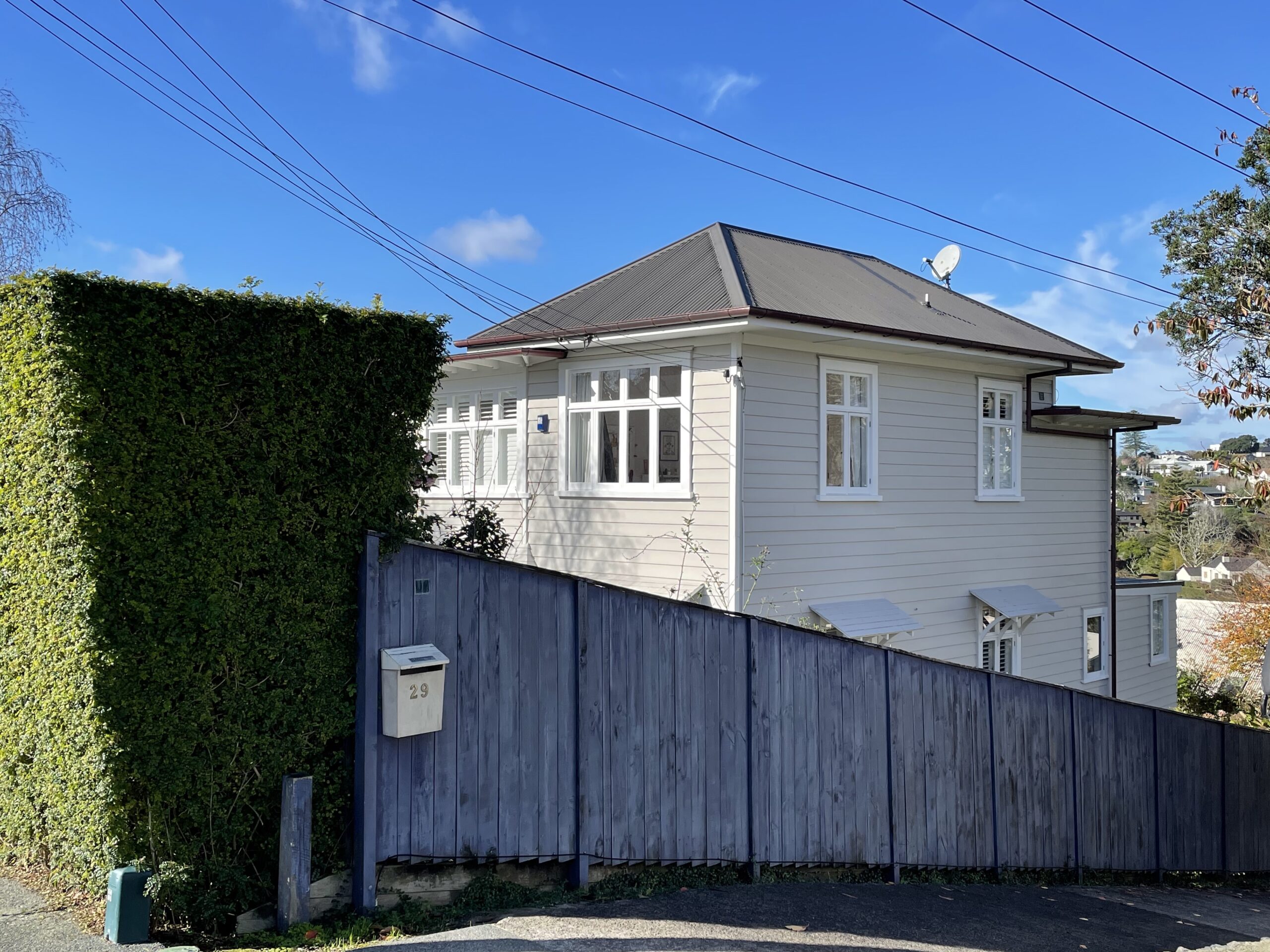
Figure 1a: Part north and west elevations of 31 Bell Road (C. O’Neil, June 2021).
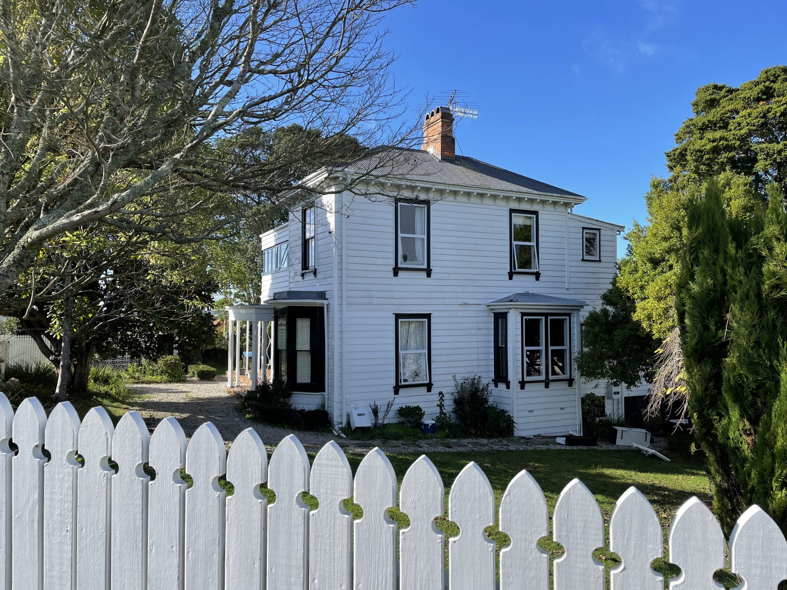
Figure 1b: Part north and east elevations of 33 Bell Road (C. O’Neil, June 2021).
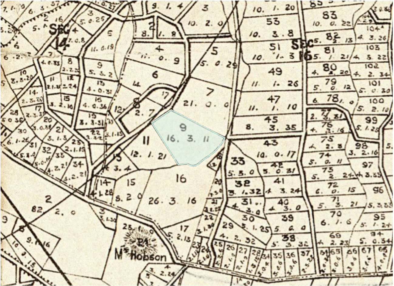
Figure 2: Extract from Champtaloup and Cooper’s map of the County of Eden, 1880. It was on original Allotment 9 (highlighted) that 31 and 33 Bell Road were later built (Auckland Libraries Heritage Collections, Map 190).
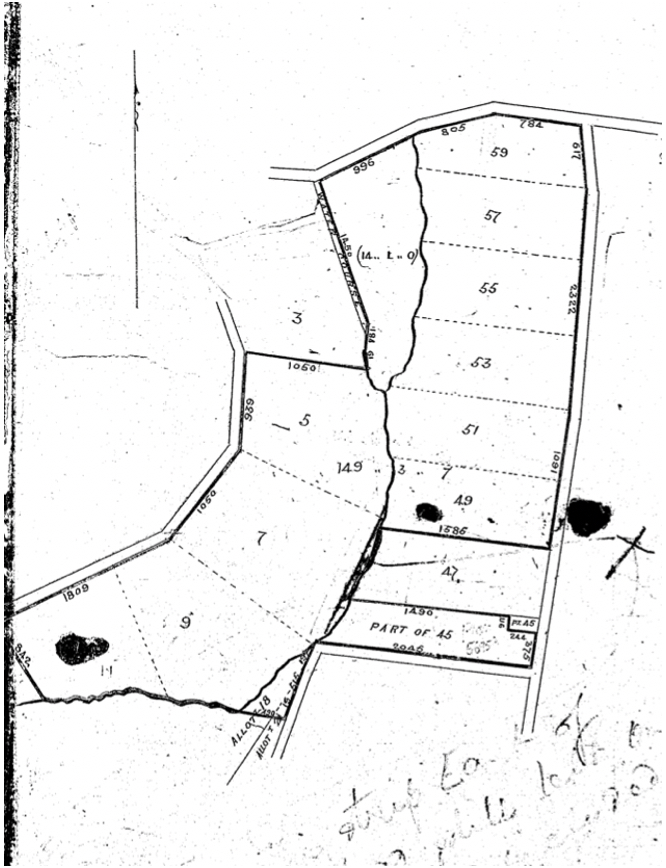
Figure 3: Showing the substantial landholding (including Allotment 9) of the New Zealand Loan and Mercantile Agency Company in 1881, located between present-day Arney Road and Victoria Avenue (Certificate of title NA22/25, Land Information New Zealand).

Figure 4: A photograph dated 1877 looking north from Mount Hobson and showing the open area of land where Bell Road and the two houses were later built. The road in the foreground is present-day Ridings Road (Auckland Libraries Heritage Collections 1342-Album-244-123-2).

Figure 5: Deposit Plan showing the subdivision of parts of allotments 5, 7 and 9. Present-day 31 and 33 Bell Road occupy lots 54 and 55 respectively (DP 366, LINZ records).
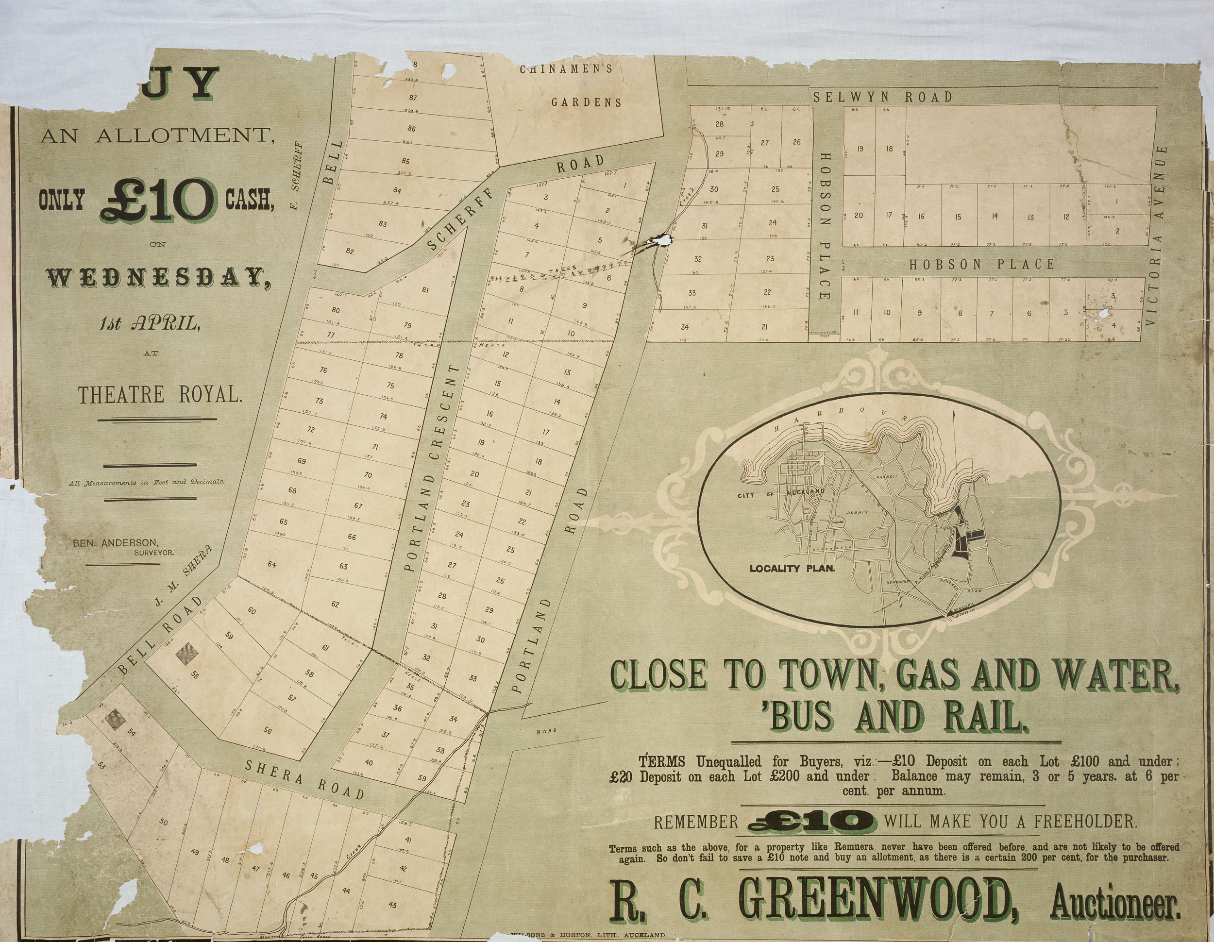
Figure 6: Poster advertising the sale of subdivided land by R. C. Greenwood in 1885. The footprints of present-day 31 and 33 Bell Road are visible on lots 54 and 55 of the subdivision (Auckland Libraries Heritage Collections NZ Map 4250).
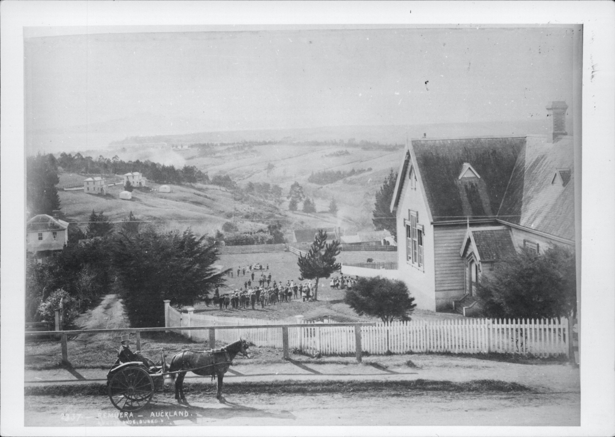
Figure 7: Looking north from Remuera Road by the Remuera Primary School in c.1885, the two houses built at present-day 31 and 33 Bell Road are seen in the distance (Auckland Libraries Heritage Collections 7-A7376).
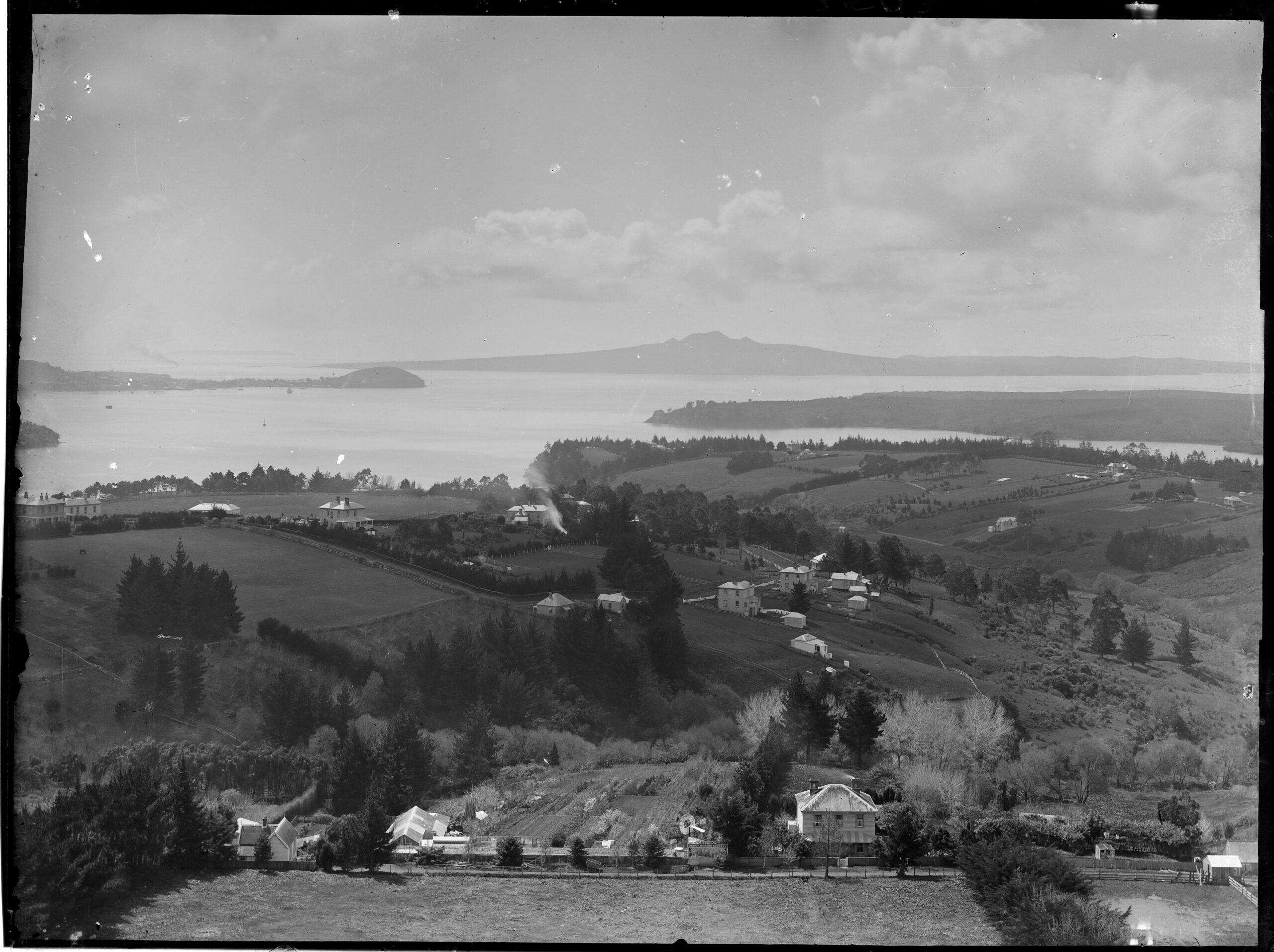
Figure 8: Looking north from Mount Hobson showing the small group of buildings on Bell Road (centre), including those at present-day 19, 23, 31, 33 and 37, in c.1890s (Auckland Libraries Heritage Collections 4-1094).
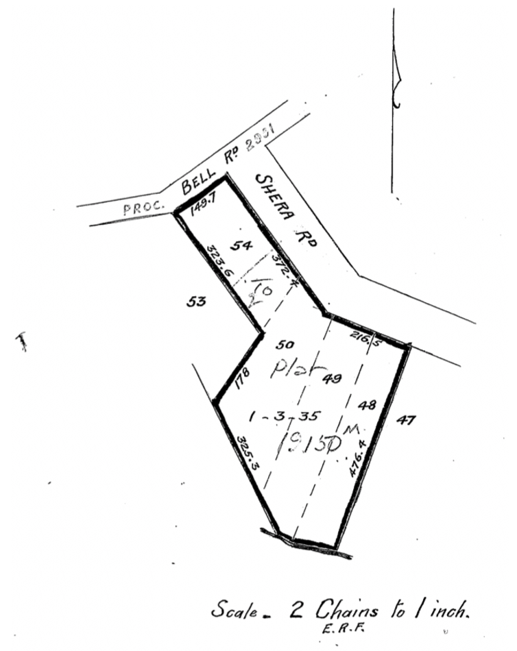
Figure 9: Showing land purchased by Lavinia Barber in 1909, which included the house at present-day 31 Bell Road (Certificate of title NA157/207, LINZ records).
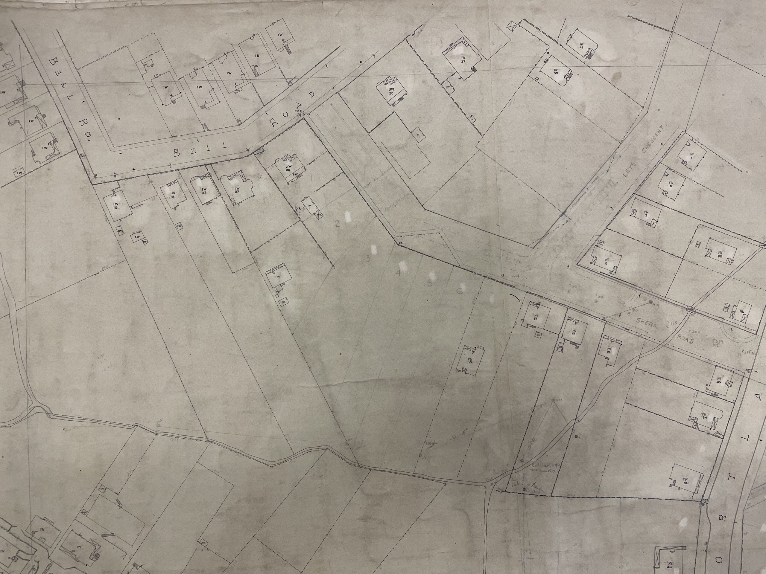
Figure 10: Auckland City Map showing the buildings (villas and bungalows) in place during the early 1920s (ACC 001 City of Auckland Map 1908, M18, Record ID 706646, Auckland Council Archives).
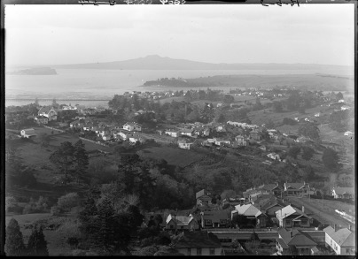
Figure 11: Showing the further houses in place on Bell Road by the early 1920s (centre) (Auckland Libraries Heritage Collections 4-4595).
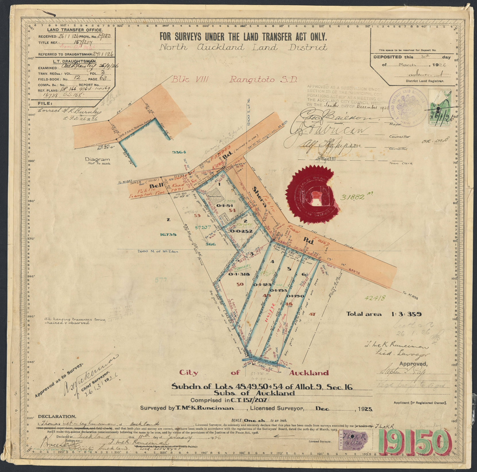
Figure 12: The subdivision of the property owned by Stephen Thomas Page into six lots 1925. Present-day 31 Bell Road was located on lot 1 on the corner of Bell and Shera roads (DP 19150, LINZ records).
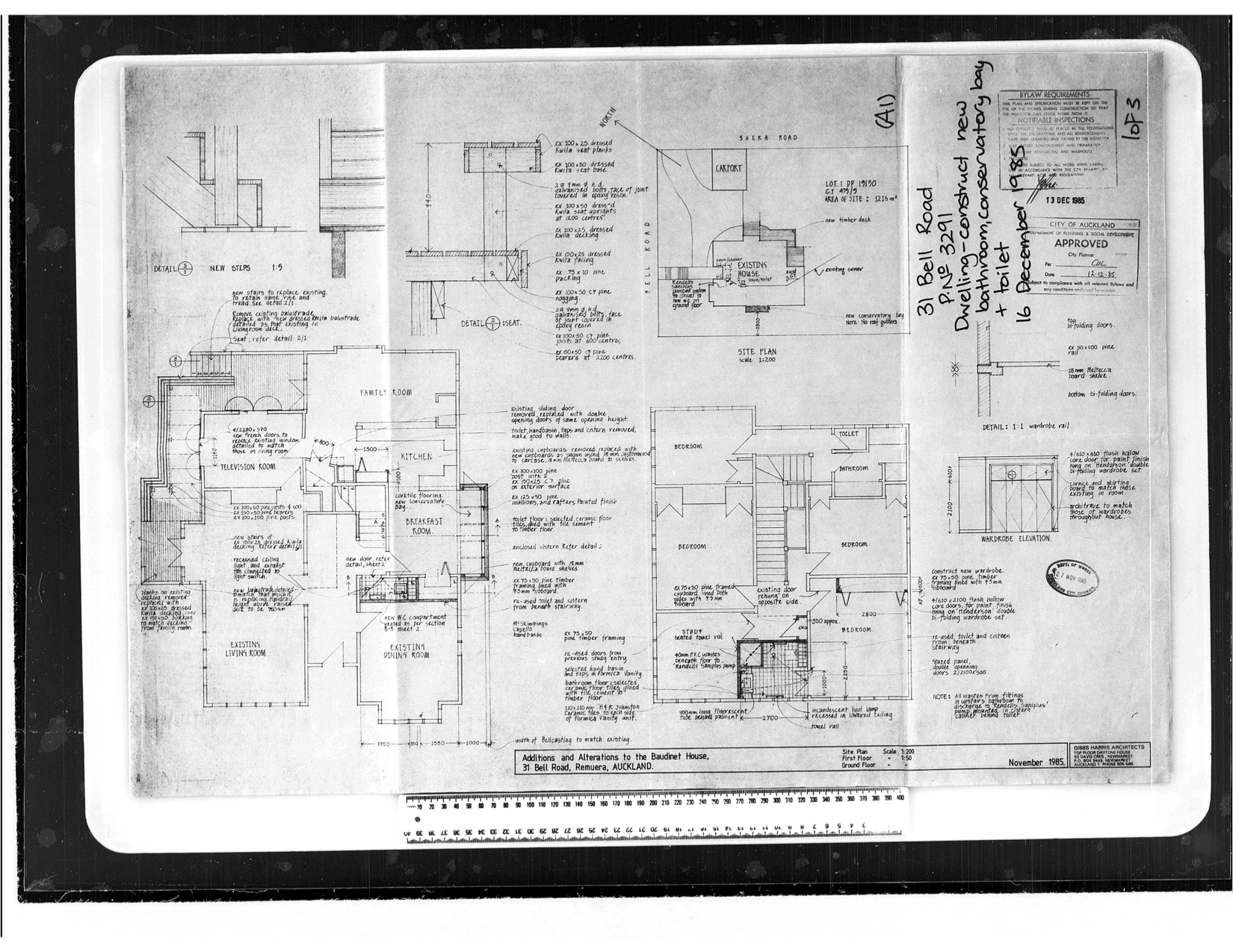
Figure 13: Architectural plans showing the changes proposed to 31 Bell Road in 1985 (AKC 339 Building Permit and Consents Aperture Cards 1908-1997, Bell Road, Record ID 177056, Auckland Council Archives).
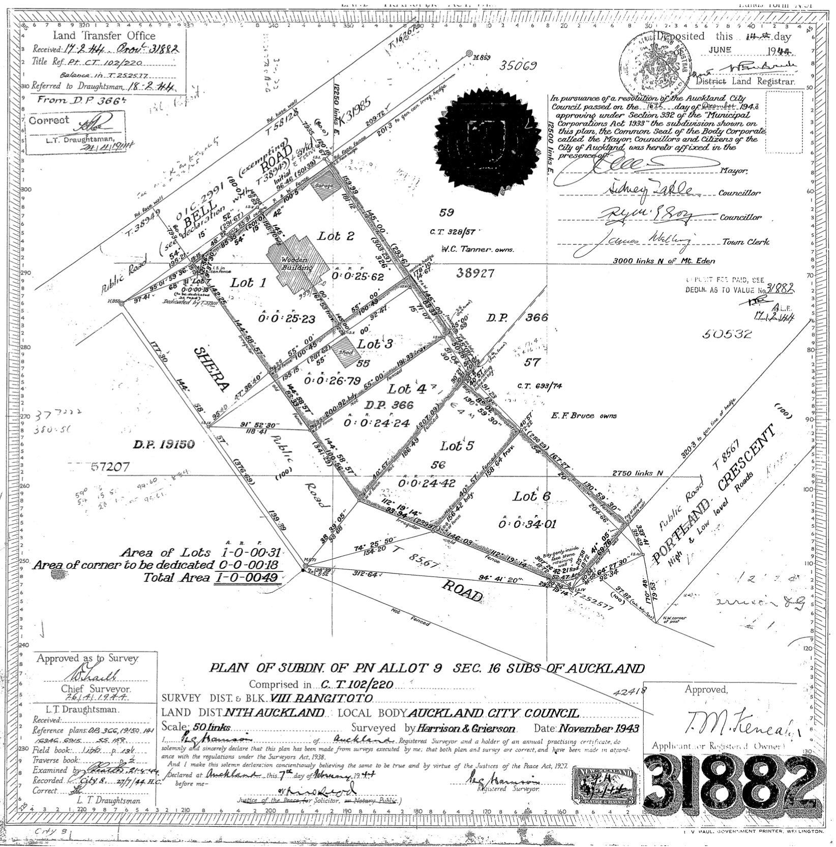
Figure 14: The subdivision of the property owned by Thomas Kenealy into six lots 1943. 33 Bell Road was on lots 1 and 2 on the corner of Bell and Shera roads (DP 31882, LINZ records).
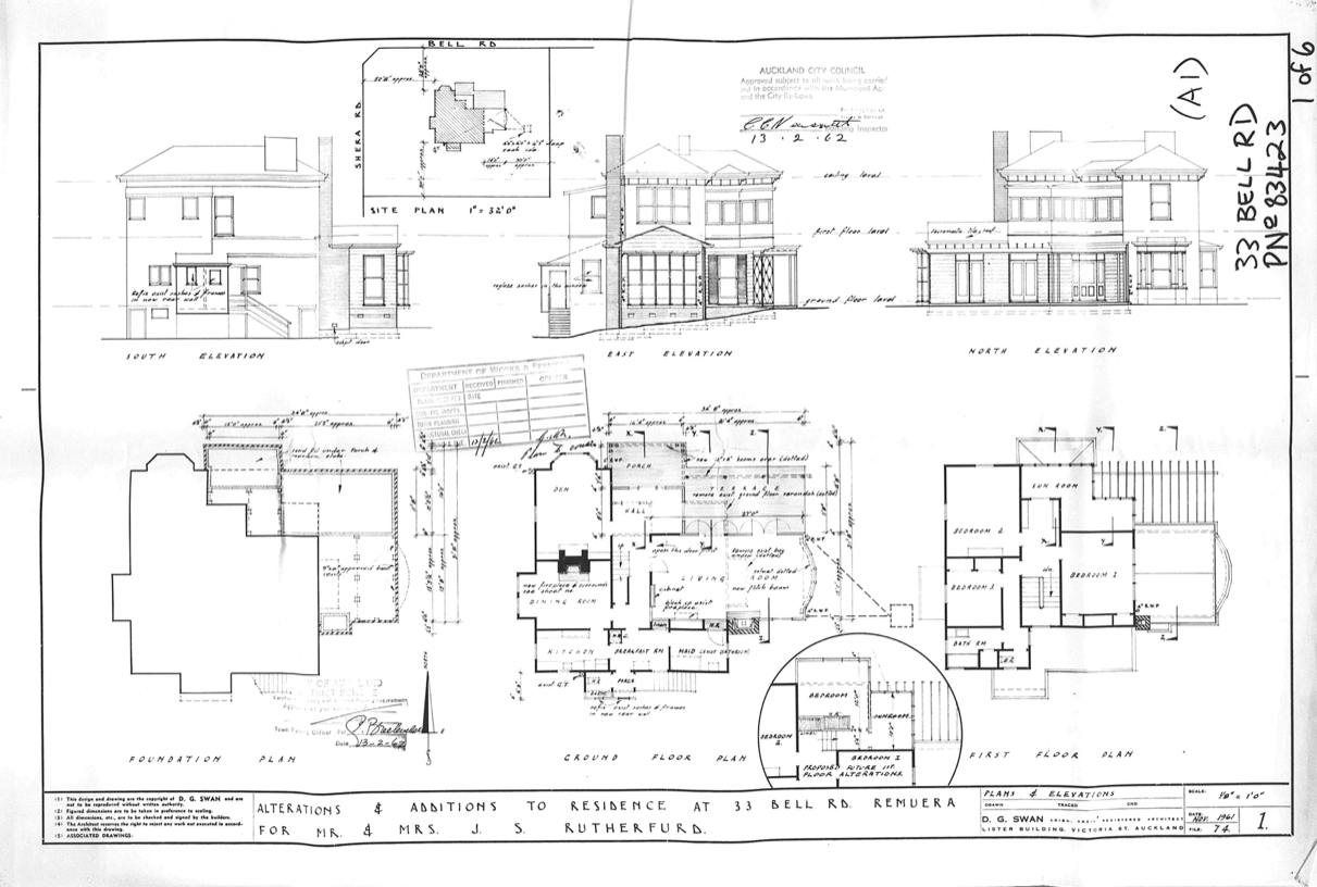
Figure 15: Architectural plans showing the changes proposed to 33 Bell Road in 1961 (AKC 338 Building Consents Mircofilm 1908, Bell Road Record ID 519344, Auckland Council Archives).
Built as identical two-storey houses in c.1885 on the corners of Bell and Shera roads, the subject residences are two of Bell Road’s earliest buildings. Although both properties have undergone varying degrees of change in their almost 140 years, they stand as a direct link to Remuera’s early residential history.
Early European land ownership
The houses at present-day 31 and 33 Bell Road were built on part of original Allotment 9, Section 16 of the Suburbs of Auckland – a 17-acre allotment on the coastal side of Tāmaki (later Remuera) Road.[1] (Figure 2) The allotment originally formed part of the ‘Ōhinerau’ blocks, areas of land on Remuera’s northern slopes that were purchased from Ngāti Whātua by the Crown between 1851 and 1853 for £250.[2] Regarded as “some of the most valuable land in Remuera”[3], the land garnered great interest and fierce competition at public auction, resulting in high purchase prices and substantial profits for the Crown.[4]
Allot. 9 was originally granted to Auckland merchant and land speculator, W. S. Grahame (1813-1894) in 1852.[5] By 1854, Grahame had acquired over 63 acres of the ‘Ōhinerau’ blocks from the Crown for just over £1,236.[6] Encompassing an area roughly bounded by present-day Remuera, Arney and Eastbourne roads, the substantial estate became known as ‘Grahame’s Farm’.[7]
Born in Glasgow, Scotland in 1813, William Smellie Grahame emigrated to New Zealand at the age of 22.[8] Settling in Auckland, Grahame became a prominent and prosperous land investor who, in 1856, was granted a total of 3,223 acres under the Land Claims Settlement.[9] Having made his fortune in the new colony, Grahame returned to Britain in 1857, settling in Surrey, England.
Grahame’s Farm (including Allot. 9) remained largely intact until around 1870 when it was purchased by Irish-born James Williamson (1814-1888) for £5,000.[10] A prominent businessman and property developer, Williamson arrived in New Zealand in early 1840 and quickly prospered.[11] By the time he acquired land in Remuera, Williamson already owned ‘Surrey Hills Estate’, a prime 314-acre suburban farm (in present-day Grey Lynn), which he would later sell for £100,000.[12,13] He subsequently purchased Pah Farm in Hillsborough where he built a palatial Italianate gentleman’s residence, known today as ‘Pah Homestead’.[14]
In 1876, Allot. 9 (and part Allot.18) was transferred from Williamson to entrepreneur, Thomas Morrin (1889-1904).[15] A Canadian of Scottish descent, Morrin arrived in New Zealand with his brother, Samuel in 1865. They soon purchased an ironmongery and hardware store on Auckland’s Queen Street, forming ‘T. & S. Morrin & Co.’.[16] By the 1870s, the brothers were prosperous merchants and landowners who lived in two of Remuera’s grandest residences; Thomas at ‘Burwood’ at Remuera Point (now Burwood Crescent) and Samuel at ‘Dunholme’ on Remuera Road.[17] They also invested heavily in land in both Remuera and in the Waikato. The latter resulted in the establishment of the 30,000-acre ‘Lockerbie’ estate in an area that would become known as ‘Morrinsville’.[18] In Remuera and Meadowbank, the brothers built up several stud farms, including a 180-acre farm called ‘Dashper Park’.[19] Situated in the Portland Road valley, it is possible that the park comprised Allot. 9 and neighbouring allotments, in which Thomas Morrin had an interest.
Subdivision and landowner changes
Thomas Morrin retained ownership of Allot. 9 until 1880, when it was acquired by the New Zealand Loan and Mercantile Agency Company Limited.[20] Established in 1864 as a subsidiary to the Bank of New Zealand, the Company was a prominent London-based pastoral finance firm that had become one of the largest of its kind in Australasia, selling stock, produce and dealing in land.[21]
In 1881, the Company was in possession of over 155 acres of Remuera land (Figure 3), which included the estate formerly owned by Morrin.[22] The substantial block of land, located between the recently-named Arney Road and Hobson Road (later Victoria Avenue), was promptly subdivided and sold over the following five years.[23,24] One of the largest purchases was made by The City of Auckland Tramways and Suburban Land Company, who acquired more than 80 acres in 1884.[25] Like many parts of Remuera at that time, the unbuilt land was characterised by large expanses of undulating grassland and stands of trees (Figure 4).
The following year, a syndicate of eight Auckland businessmen, incited by the audacious land agent and auctioneer, Robert C. Greenwood, bought 48 acres from the Tramways and Suburban Land Company for over £8,000.[26] The property was swiftly subdivided into allotments and advertised for sale by Greenwood. The “large and well-situated allotments” were laid out around the newly established streets of Bell Road, Portland Crescent, Scherff Road and Shera Road (figures 5 and 6).[27, 28]
On lots 54 and 55 of the new subdivision, the footprints of two houses were shown on the subdivision poster and were specifically mentioned in an 1885 newspaper advertisement as follows:
“On allotments Nos. 54 and 55, with frontages to Bell Road, there are erected two well-built and convenient 9-roomed houses, one of them having a large stable adjoining. The houses are at present occupied by Messrs A. Hills and Goodwin.”[29].
These two identically-built houses are those that stand at 31 and 33 Bell Road today, albeit with varying degrees of modification. Built on open land that sloped eastwards towards the Portland Road valley, the two kauri houses were the first to be established on Bell Road (Figure 7). By the end of the 1890s, they had been joined by several other residences, including those at present-day 19, 23 and 37 Bell Road (Figure 8).
When Greenwood’s syndicate went into bankruptcy in 1889, large tracts of the subdivided land was transferred to the Bank of New South Wales, who gradually on-sold the lots over the next two decades.[30]
31 Bell Road
Built by 1885, the house at present-day 31 Bell Road occupied Lot 54 of the residential subdivision established that same year. In 1901, it was purchased by Lydia Annie Hendry, the wife of sharebroker, James Thomas Hendry, as part of a larger acquisition of land that also comprised lots 37-50.[31] Measuring over five acres, the landholding extended along the southern side of Shera Road between Bell Road and Portland Road and on the northern side of Shera Road between Portland (now Leys) Crescent and Portland Road.[32]
Following Mrs Hendry’s death in 1909, the house and two acres of adjoining land (lots 54 and 48-50) on Shera Road was purchased by widow, Lavinia Barber (Figure 9).[33] Born in Ireland, Mrs Barber arrived in Auckland as a child. In 1875, she married William F. Barber, the grandson of Lieutenant General William Taylor who owned the West Tamaki estate ‘Glen Orchard’ in present-day St Heliers.[34] Lavinia Barber retained ownership of the property until 1913 when it was transferred to Frances Emily Barber, presumably a relative.[35] Shortly after this time, valuation field sheets recorded the property as a ‘wood house and shed’, with a capital value of £1,200.[36]
In 1919, the house and adjoining land was purchased by Auckland accountant, Brent Llewellyn Bagnall for £1,600.[37] At that time, the corner property was addressed 23 Bell Road and comprised a two-storey, seven-roomed wood house with slate roof, a shed, and almost four acres of land.[38] Bagnall owned the property for just over a year before it was acquired by farmer, George Alexander Dunbar and his wife, Mary.[39]
Scottish-born George Dunbar arrived in New Zealand in the 1870s, initially spending time in the South Island working for his uncles, Messrs Dunbar and Stewart, who were well-known farmers and importers of Clydesdale horses.[40] He later relocated north with his family; first to Taranaki and then to Cambridge where they remained until their move to Remuera in 1919-20. The Dunbars retained ownership of the property on the corner of Bell and Shera roads until 1925 when they decided to return to their Cambridge farm.[41] It was sold to Mount Eden-based builder, Stephen Thomas Page for £2,375.[42]
By that time, more houses had been built along the street, including villas at present-day 12, 20, 25, and 27 Bell Road (latter demolished) and bungalows at present-day 14, 16 and 18 Bell Road (figures 10 and 11).
Subdivision of property
Most likely purchased by Page as an investment during the building boom of the 1920s, the four-acre property was swiftly surveyed and subdivided into six residential lots (Figure 12). The subject two-storey house stood on Lot 1 of the new subdivision, and, by that time had been in place for at least 40 years. Although Page retained ownership of the property, it was periodically tenanted over the following two decades and the address changed to 29 Bell Road.[43]
The first of the five remaining subdivided lots to be sold was Lot 3 (present-day 7 Shera Road). Purchased in 1927 by Joseph Arthur Massam, a house was built at some stage during the 1930s. In 1940, Lot 2 (present-day 5 Shera Road) was transferred to His Majesty the King for the purposes of the Housing Act 1919, possibly to enable the erection of more affordable worker’s housing. Finally, in 1948, lots 4, 5 and 6 (present-day 9, 11 and 13/13A Shera Road) were acquired by Albert Edward Sutton.[44]
Subsequent owners and changes
In 1946, retired postmaster, Samuel James Williams and his wife, Grace Isabel purchased present-day 31 Bell Road, and it remained in their family until 1963.[45] For the following 16 years, the property was owned by company director, Peter John Osborne, who, in 1972 commissioned plans for the installation of a swimming pool to the south-east of the house, which still exists today.[46] Between 1979 and 1985, 31 Bell Road changed hands on three occasions.[47]
When Auckland accountant Ian Baudinet and his wife, Joanna purchased the property in 1985, the then 100-year-old house comprised a front entry, large living room, dining room, kitchen, television room and family room on the ground floor and four bedrooms, a study and a bathroom on the first floor.[48] By this time, the original garden shed to the rear had been removed and a car port had been built close to the Shera Road boundary. Later that year, architectural plans were prepared for alterations and additions to the house. Drawn up by Gibbs Harris Architects, the works involved a new conservatory bay, new decking, new fenestration and internal alterations, including a new bathroom and toilet, and cost $3,700 (Figure 13).[49]
In 1993, the property was transferred to Peter and Jennifer Uffindell and remained in their ownership until 2005, when it was purchased by the current owners.[50] Between 2010 and 2015, a large two-storey addition was built to the east of the house.
As of 2022, the residence at 31 Bell Road is still in use as a private house. Despite the building’s links with Remuera’s early residential development, the extent of its additions and alterations means that it is no longer recognisable as the building it once was.
33 Bell Road – ‘Tralee’
The identically built house at present-day 33 Bell Road was also in place by 1885. It occupied Lot 55 of the residential subdivision that had been established that same year. In 1901, the property and neighbouring Lot 56 was purchased from the Bank of New South Wales by Harriet Mellsop Jerram (nee. Speedy) (1854-1934) for £300.[51,52]
Born in 1854, Harriet arrived in New Zealand as a child. She was the daughter of Major James Speedy, who was the Resident Magistrate and military commander for Mauku, Waiuku and Pukekohe in the 1860s and one of south Auckland’s earliest settlers.[53] In 1877, at Waiuku’s Trinity Church, Harriet married commission agent, James Tait Jerram (1846-1906).[54,55] By the time they moved to Remuera, James had been in poor health for several years. He passed away in 1906.[56] Harriet continued to live at the house on Bell Road, advertising it for sale around ten years later. At that time, it was described as a two-storey wood house with slate roof, a shed and just over an acre of land.[57] It remained unsold until 1920 when it was purchased by postal clerk, Thomas Michael Kenealy for £1,375.[58]
Born in 1885, Thomas was the son of Jeremiah (Gerald) and Mary Kenealy, who had previously owned property in Remuera.[59,60] Hailing from Ireland, Jeremiah moved to New Zealand with members of his family, who were well-known sporting personalities, and became associated with the breeding of racehorses.[61] It was in Auckland that he met and married Irish-born Mary (nee. Hogan), with whom he would have six children.[62]
Although Thomas was recorded as the owner and occupier of the Bell Road property, records suggest that it was also the home of his parents. During their residence, the house was named ‘Tralee’, after the Irish town where Mary grew up.[63] Jeremiah and Mary continued to live at Tralee until their respective deaths in 1931 and 1944.[64]
While residing at the property, a number of changes were undertaken by the Kenealys. In 1927, plans were prepared for the construction of a garage for J. Kenealy. Built on the northern corner of the Bell Road boundary, the modest structure cost £35.[65] The greatest change, however, occurred in 1943 when the land upon which Tralee stood (lots 55 and 56) was surveyed and subsequently subdivided in six lots (Figure 14).[66]
Subdivision of property
Tralee occupied lots 1 and 2 of the subdivision, which became present-day 33 Bell Road. The property remained in the ownership of Thomas, while the four remaining lots were sold in 1944.[67] Lot 3 (present-day 4 Shera Road), which comprised the early shed was purchased for £300 by draughting engineer, Ernest Stein and his wife. A building permit for a dwelling was acquired that same year with an estimated cost of £1,560. Lot 5 (and possibly Lot 4) (present-day 6 and 8 Shera Road) was acquired by artist, Edward John E. Holmwood and his wife Freda for £400. Lot 6 was transferred to Stephanie Bonny.[68]
Subsequent owners and changes
After 30 years of ownership, Thomas Kenealy sold Tralee in 1951.[69] It was acquired by accountant, John Spencer Rutherford and recorded around that time as a seven-roomed house with a double garage.[70] In 1957, plans were drawn up for alterations and additions to the property. Prepared by Walker, Hillary & Swan Architects, works comprised a first floor addition to accommodate a bathroom and internal changes. Further proposed changes during Rutherford’s ownership included the enlargement of the living room and the construction of a porch and terrace in 1961 (Figure 15), and the replacement of the existing double garage with a carport.[71]
In 1978, the property was transferred to Leslie and Elaine Healey and changed hands periodically over subsequent years. It was purchased by the current owner in 2013.[72]
As of 2022, the residence formerly known as Tralee at 33 Bell Road is still in use as a private dwelling. Despite having undergone some changes over its almost 140 years, the building’s original form and aspects of its early fabric and features are still visible, and enable it to be appreciated as one of Remuera’s early residential buildings.
Carolyn O’Neil
Heritage Consultant
The Heritage Studio
March 2022

Background
The Heritage Studio Limited was commissioned by Remuera Heritage to undertake research to gain an understanding about the history of the residences at 31 and 33 Bell Road, Remuera. The principal aim of the research was to assist in the preparation of a ‘story’ of the places for Remuera Heritage’s ‘Century-Old Homes’ campaign.
Research involved viewing online repositories such as DigitalNZ, Papers Past and Auckland Libraries resources; sourcing available information at Auckland Council Archives and at Auckland Libraries Research Centre; and viewing early Deeds Indexes and Certificates of Title from Archives New Zealand and Land Information New Zealand (LINZ). Research was undertaken to an extent that met the requirements of the brief, but was not necessarily exhaustive. It is important to note that opportunities still exist to explore other avenues of research, which may yield more detailed information.
Access onto the site and inside the properties has not been made.

This story has been made possible by the generous sponsorship of Barfoot and Thompson, Remuera.
Subscribe to our newsletter to keep up to date.
Related Stories
RETURN TO TOP
