‘Capri’, 231 Remuera Road, Remuera (Remuera’s Century-Old Homes Project)

Figure 1: The principal (east) elevation of ‘Capri’, viewed from the front garden (C. O’Neil, June 2022).

Figure 2: Extract from Champtaloup and Cooper’s map of the County of Eden, 1880. It was on original Allotment 4 (highlighted) that Capri was later built. Note how Market Road cuts through the allotment (Auckland Libraries Heritage Collections, Map 190).
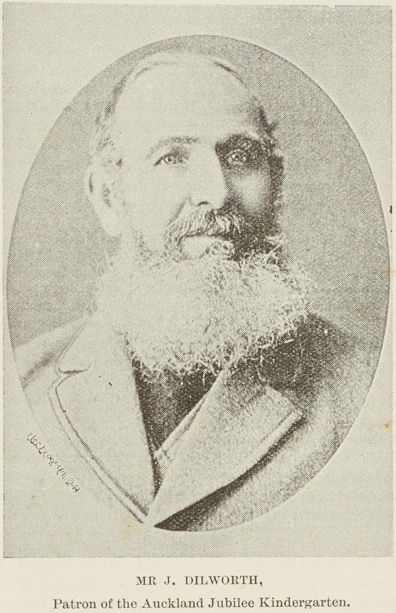
Figure 3: Portrait of Mr James Dilworth, 1891 (Auckland Libraries Heritage Collections NZG-18910523-0007-01).

Figure 4: Plan showing part of James Dilworth’s estate between present-day Remuera, Market, Great South and St Marks roads, dated c.1866. Allotment 4 (circled) was in use at that time as pasture (Auckland Libraries Heritage Collections Map 7205-2, owned by the Dilworth Trust Board).

Figure 5: Portrait of architect, Arthur P. Wilson (Cyclopedia Company Limited, The Cyclopedia of New Zealand [Auckland Provincial District: Wilson, Arthur P., Christchurch, 1902, New Zealand Electronic Text Collection).
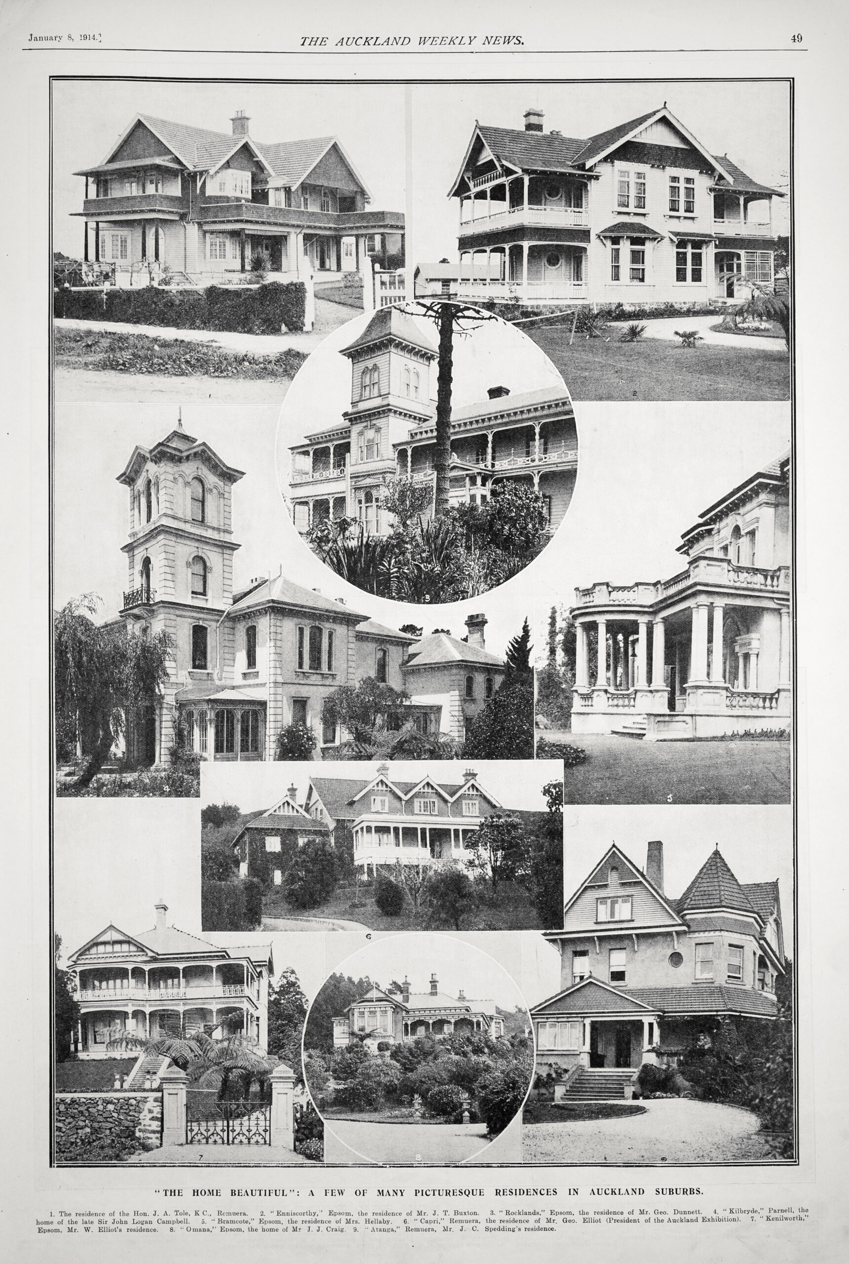
Figure 6: ‘The Home Beautiful’ feature from Auckland Weekly News, 8 January 1914, showing a collection of ‘picturesque residences’ in Auckland, including ‘Capri’ (Auckland Libraries Heritage Collections AWNS-19149198-49-1).
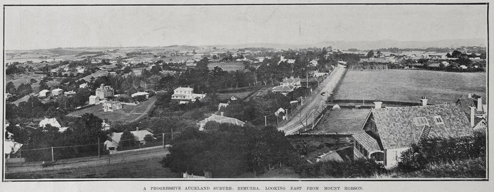
Figure 7: Looking east across Remuera from Mount Hobson, showing ‘Capri’ (bottom right) in 1906 (Auckland Libraries Heritage Collections AWNS-19060419-16-2).
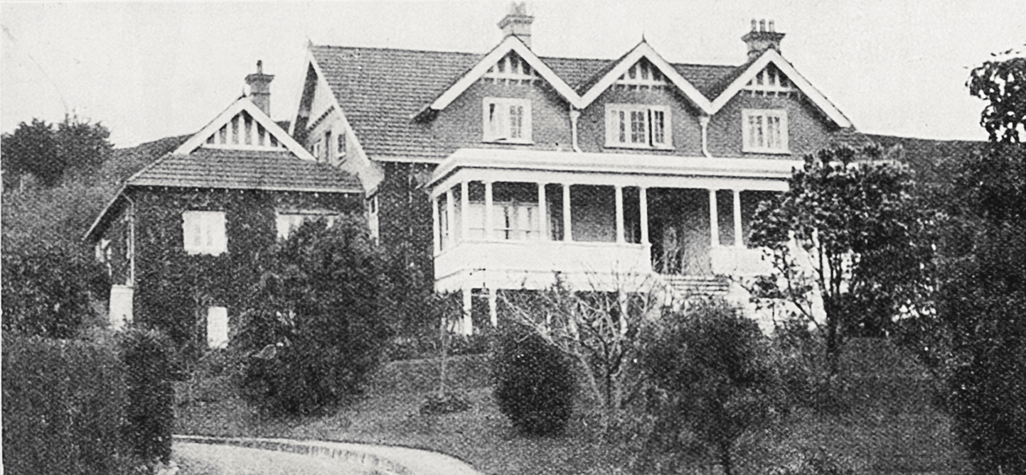
Figure 8: ‘Capri’ in 1914 (extract from Figure 6, Auckland Libraries Heritage Collections AWNS-19149198- 49-1).
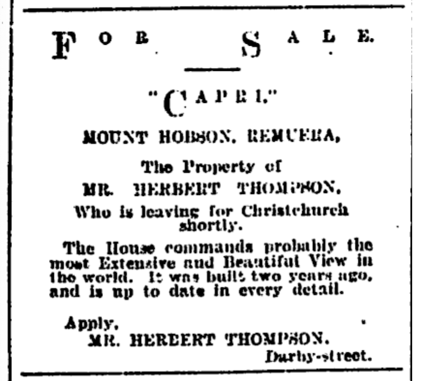
Figure 9: Newspaper advertisement showing ‘Capri’ for sale (Page 1 Advertisements Column 5, New Zealand Herald, Volume XLII, Issue 12793, 17 February 1905, Papers Past).

Figure 10: Portrait of George Elliot (Auckland Libraries Heritage Collections AWNS-19181031-32-3).
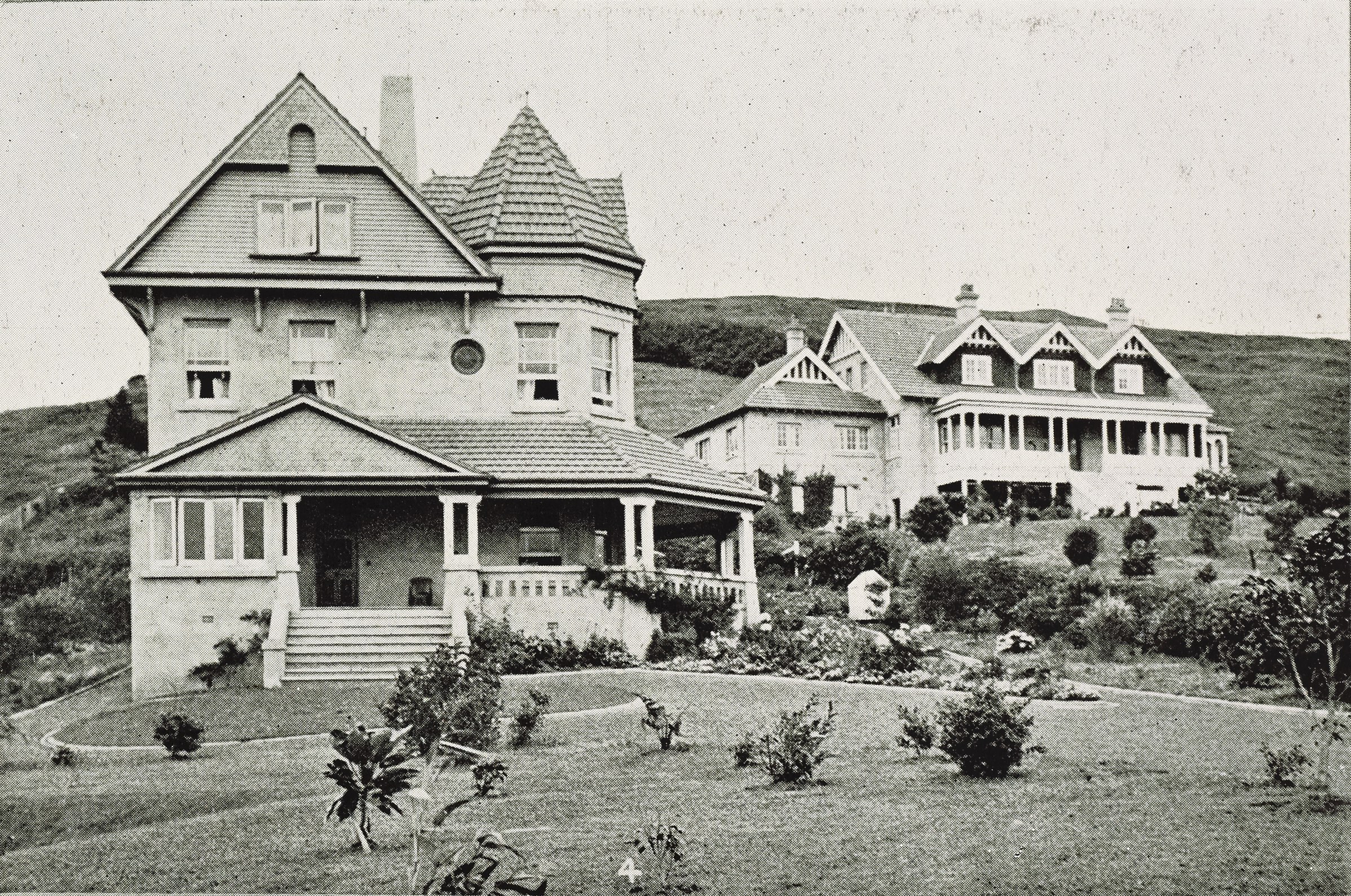
Figure 11: ‘Atanga’ (now demolished) with ‘Capri’ in the background, 1909 (extract from a New Zealand Graphic feature showing a collection of well-known houses, Sir George Grey Special Collections, Auckland Libraries, NZG-19090120-26-1).
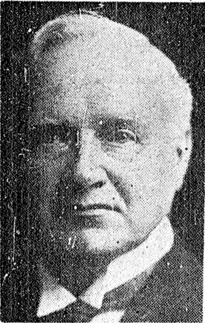
Figure 12: Portrait of H. M. Smeeton (Prominent Citizen’s Death, New Zealand Herald, Volume LXIV, Issue 19782 November 1927, Papers Past).
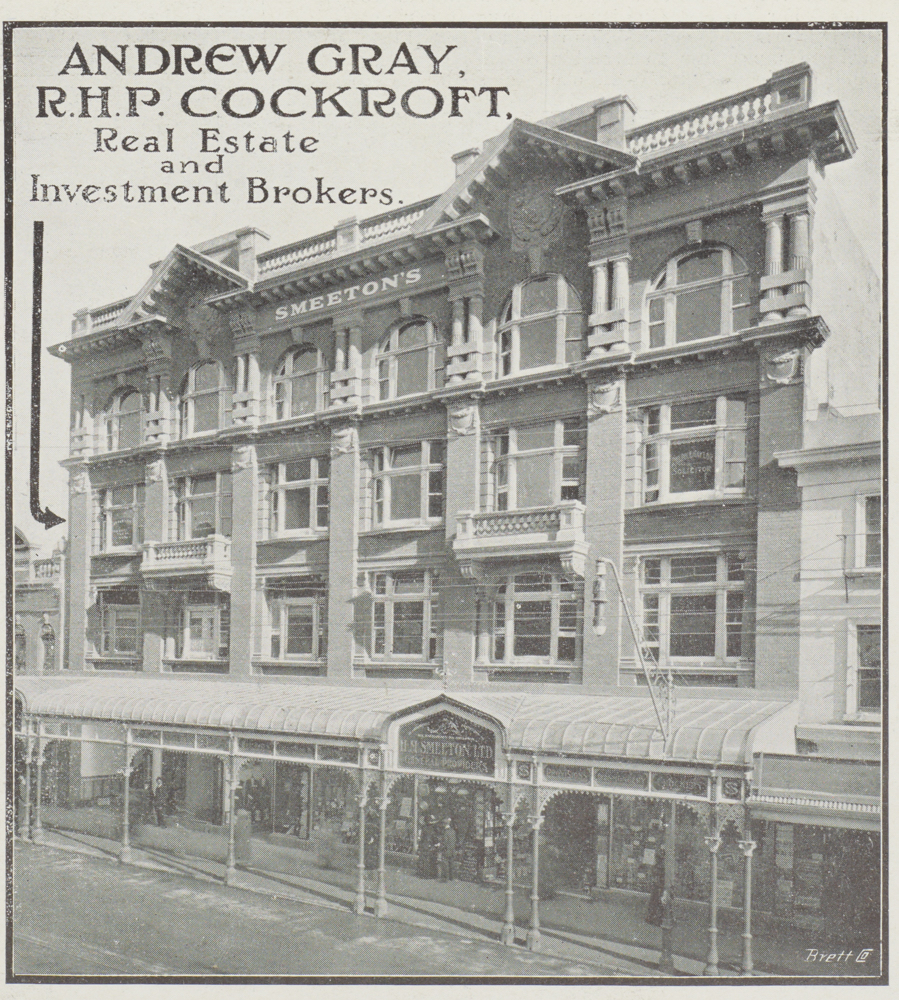
Figure 13: Smeeton’s Buildings, 1912 (Auckland Libraries Heritage Collections NZG-19121009-36-2).
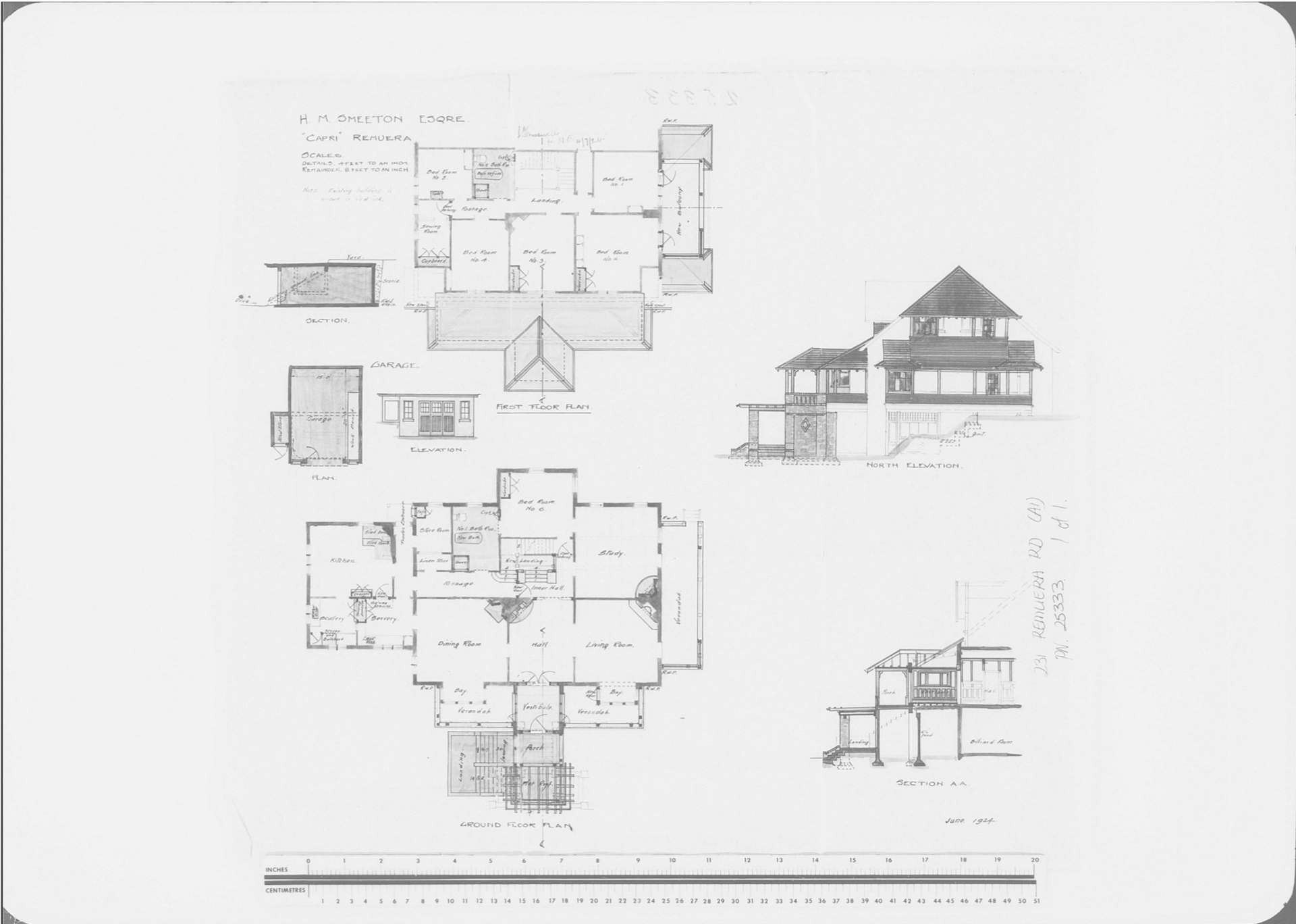
Figure 14: Architectural drawings showing alterations and additions to ‘Capri’, dated June 1924 (AKC 339 Building Permit and Consents Aperture Cards, Record ID: 178633, Auckland Council Archives).
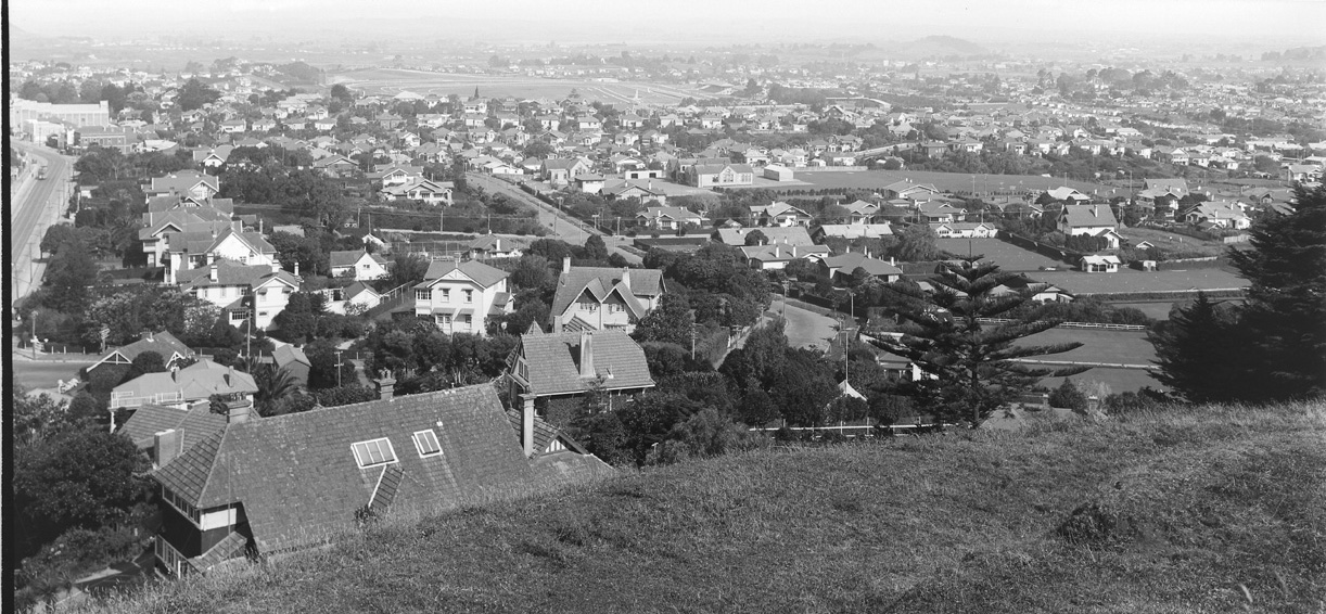
Figure 15: Looking south east across Remuera from Mount Hobson, showing ‘Capri’ (bottom left) in 1931 following the alterations carried out, including the balcony on the north elevation (Auckland Libraries Heritage Collections 4-8446).
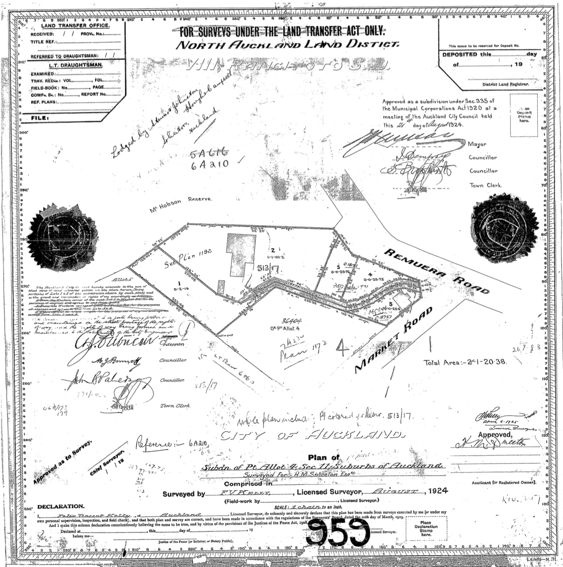
Figure 16: Deposit Plan 959 showing the subdivision of H. M. Smeeton’s estate into five lots. The footprint of present-day 231 Remuera Road can be seen on Lot 2 (DP 959, LINZ records).

Figure 17: Showing Capri/Binswood in c.1927 just before it commenced its new use as the New Zealand Baptist Theological College (The College. A Dream Fulfilled, The New Zealand Baptist, 43rd year of issue, no. 467, January 1927, 3).
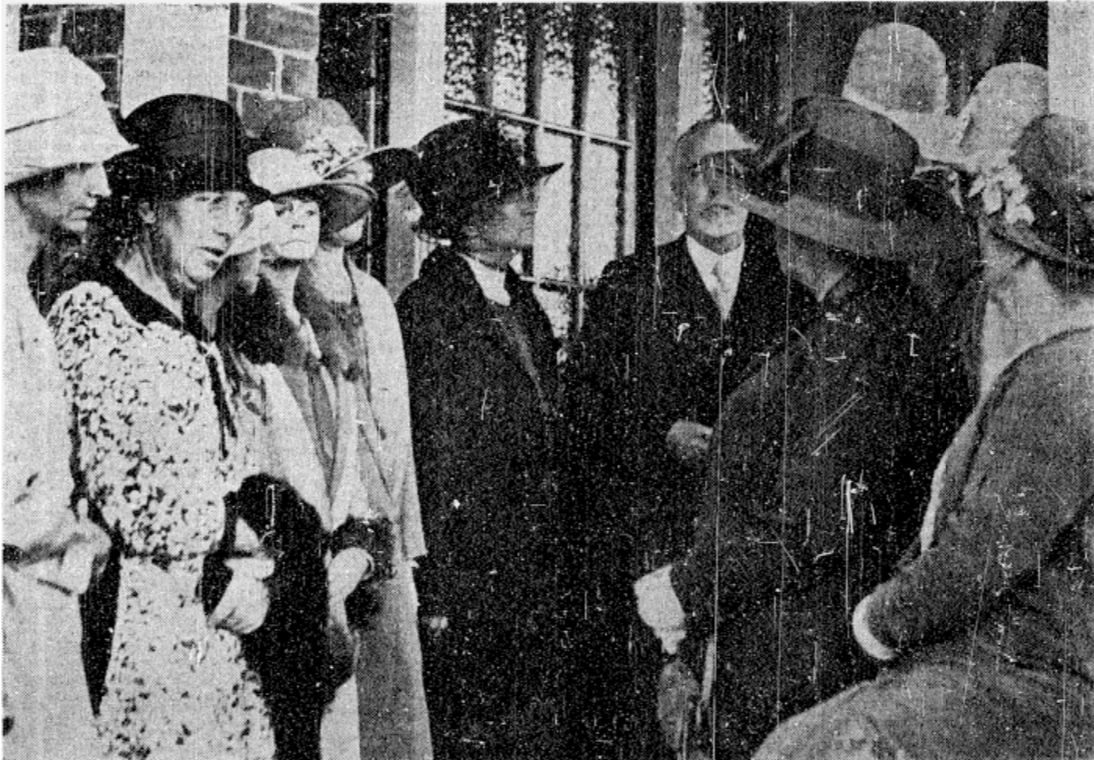
Figure 18: Photograph taken at the opening ceremony of the new Baptist Theological College, with Mrs Smeeton pictured centre (The Openings of the New Baptist Theological College at Remuera, New Zealand Herald, Volume LXV, Issue 19884, 1 March 1928, Papers Past).
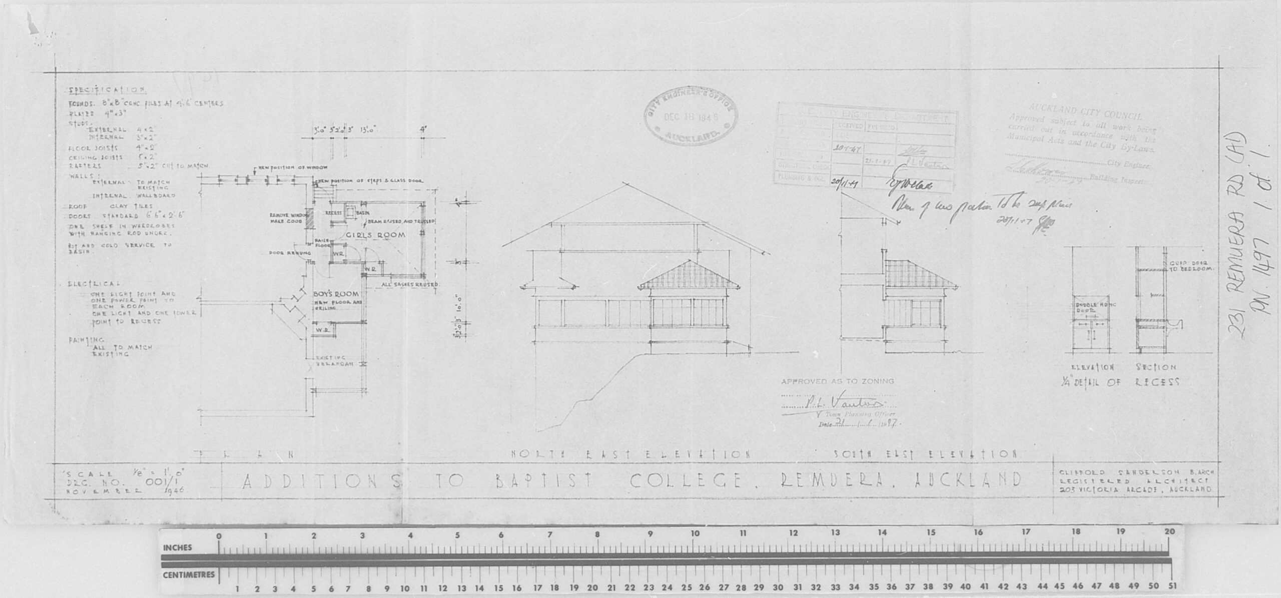
Figure 19: Architectural drawings prepared by Clifford Sanderson for the Baptist College in 1946 showing the proposed addition to the north verandah (AKC 339 Building Permit and Consents Aperture Cards 1908-1997, Remuera Road (up to 519), Record ID: 178633, Auckland Council Archives).
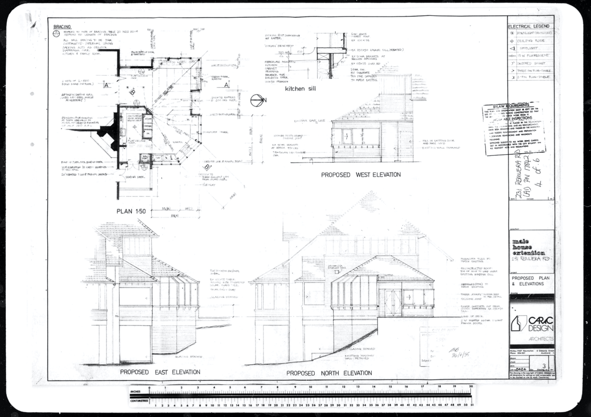
Figure 20: Architectural drawings prepared by Carac Design for K and S Male in 1985 showing the proposed addition to the north elevation to accommodate a new kitchen (AKC 339 Building Permit and Consents Aperture Cards 1908-1997, Remuera Road (up to 519), Record ID: 178633, Auckland Council Archives).
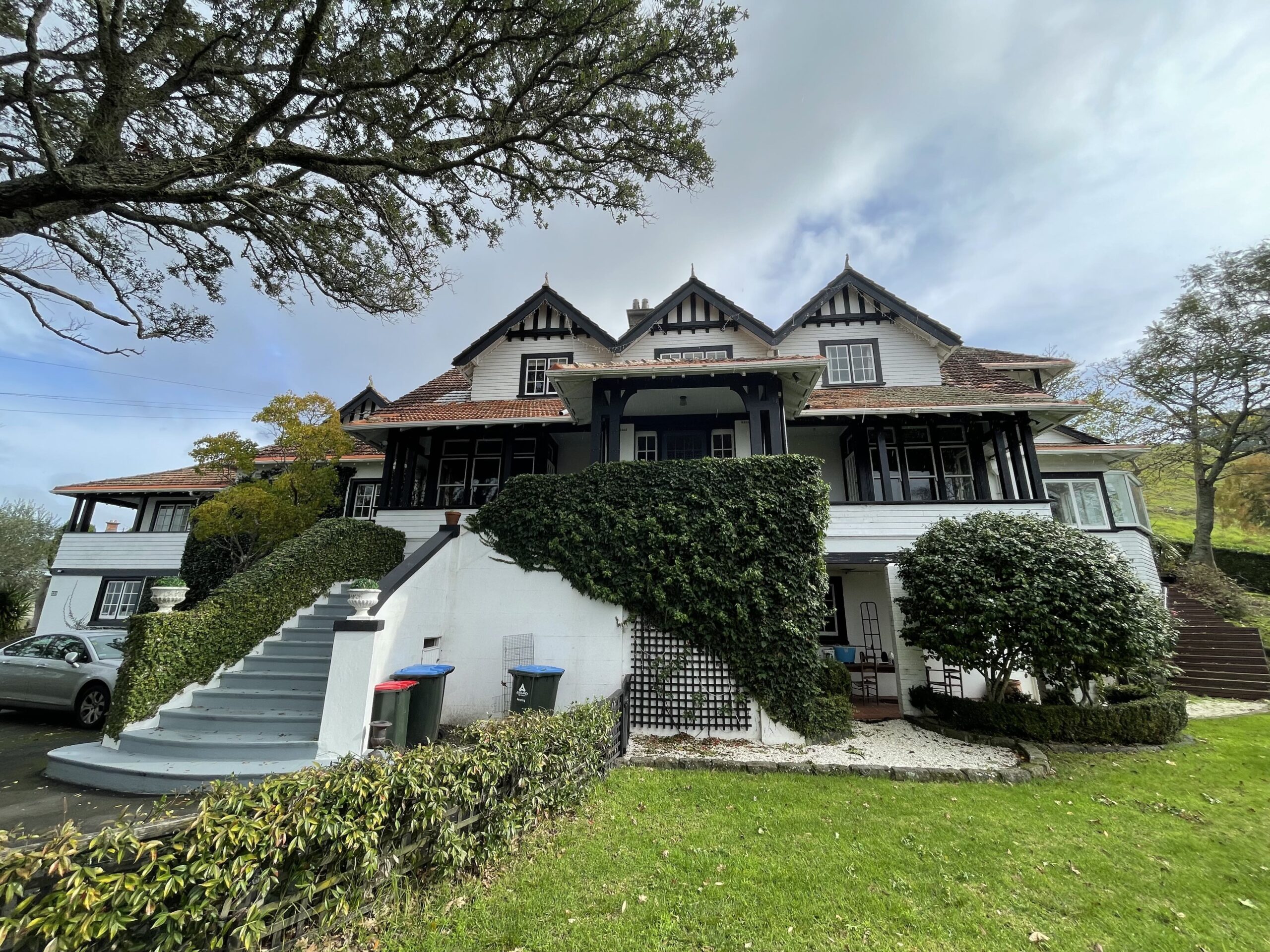
Figure 21: East (front) elevation of present-day 231 Remuera Road showing the new entrance steps added in 2010 (C. O’Neil, June 2022).
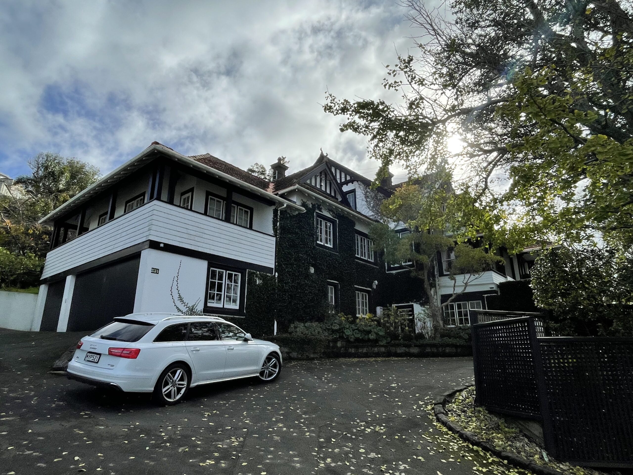
Figure 22: Parts of the east (front) and south elevations of present-day 231 Remuera Road, viewed from the shared access. The two-storey extension added in 2010 can be seen far left (C. O’Neil, June 2022).
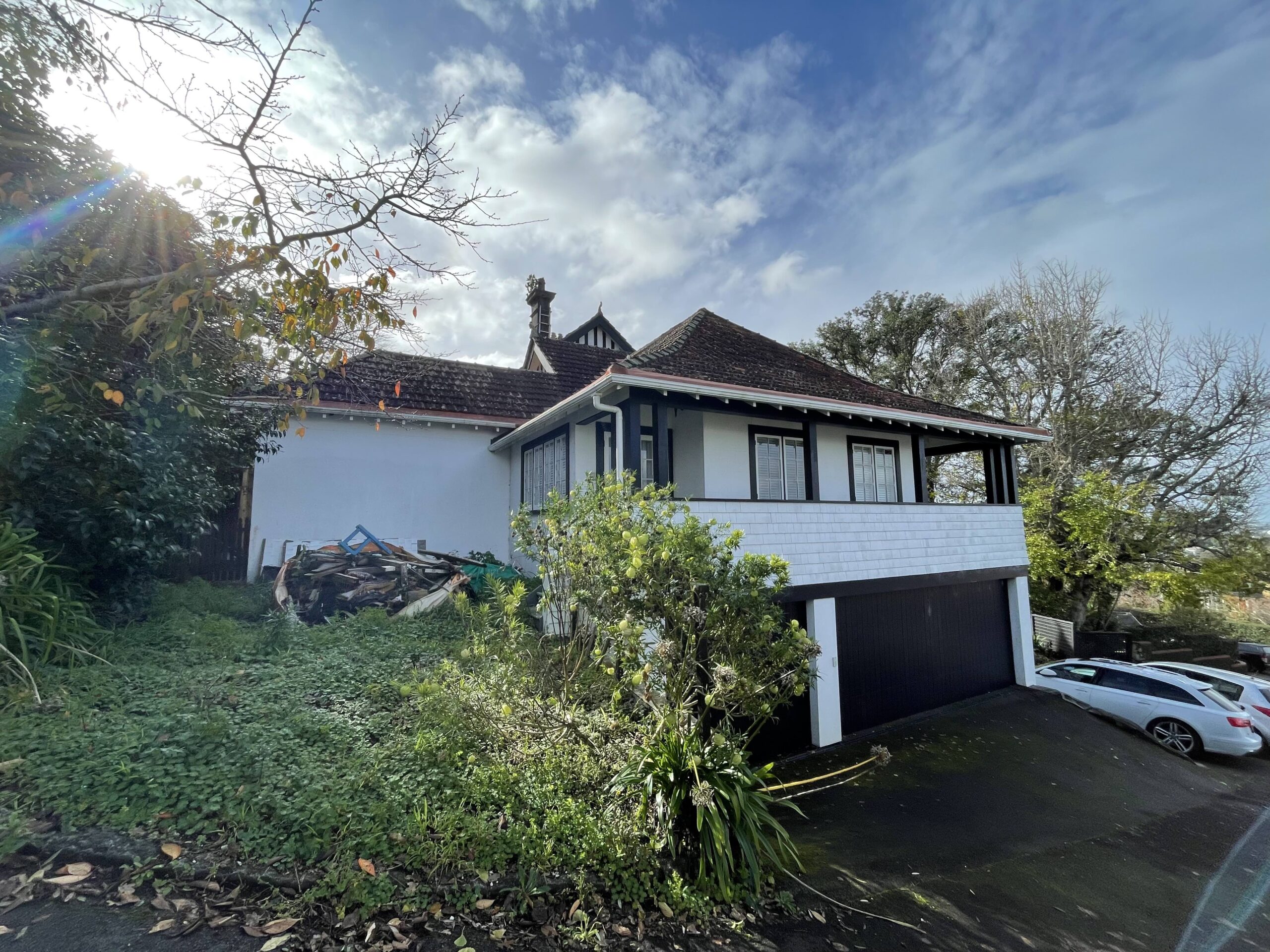
Figure 23: Parts of the south and west (rear) elevations of present-day 231 Remuera Road, showing the two-storey extension added in 2010 and the single-storey rear extension added in c.1939 (C. O’Neil, June 2022).
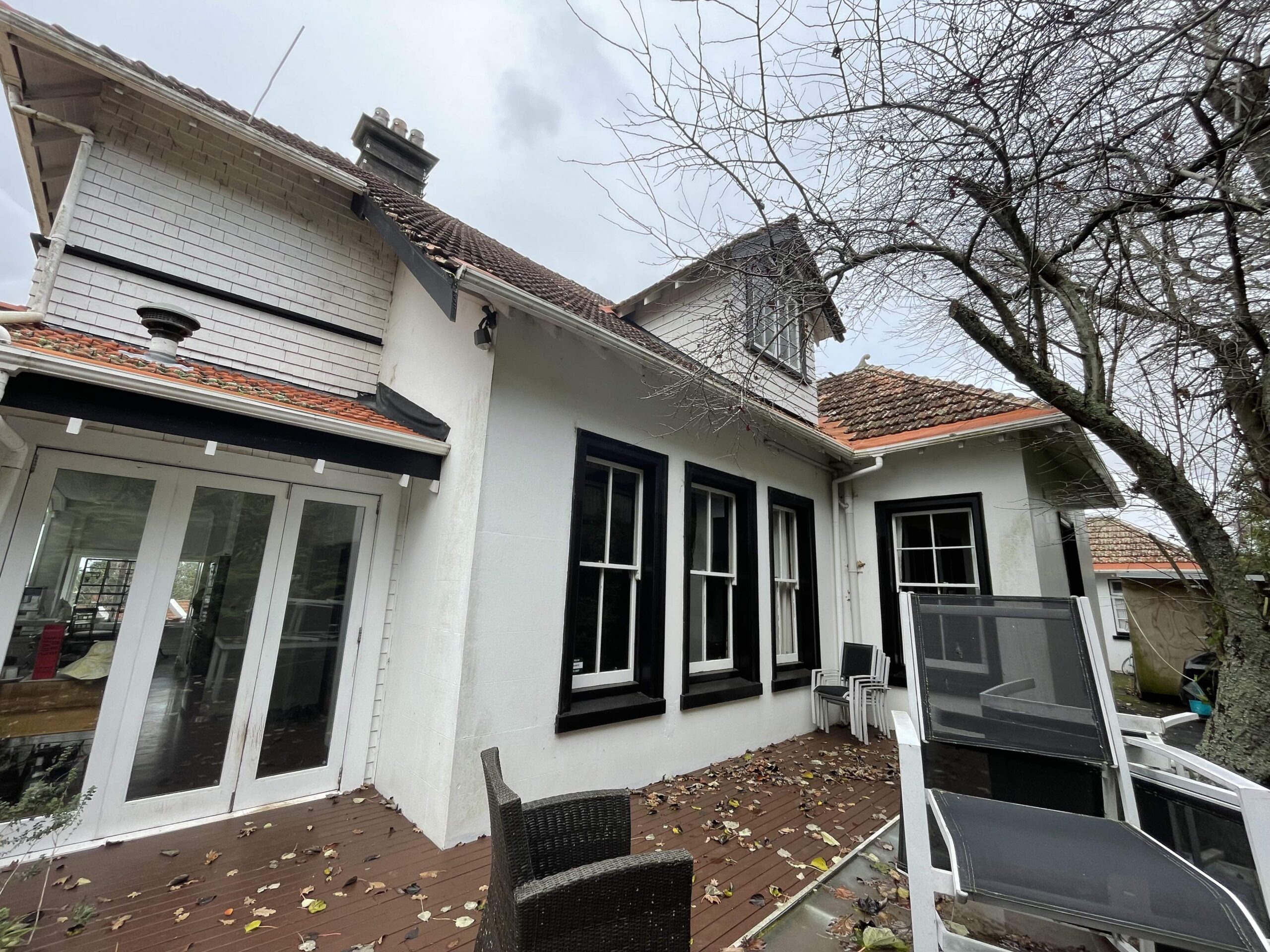
Figure 24: Part of the west (rear) elevation showing the changes to the windows undertaken in c.1946 and 1985, and the dormer window added in c.2010 (C. O’Neil, June 2022).
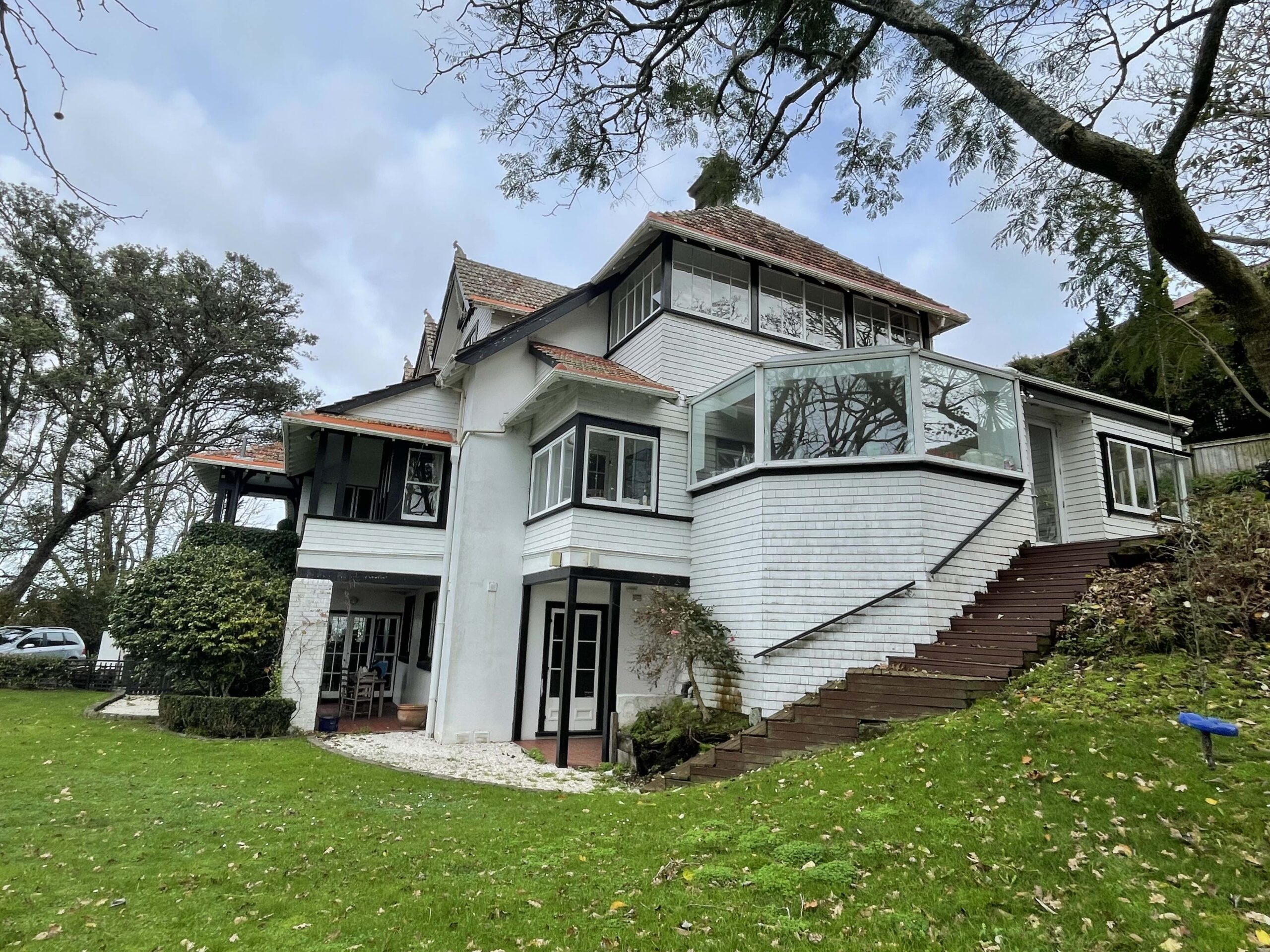
Figure 25: Parts of the north and east (front) elevations showing the first floor balcony added in c.1924 and the kitchen extension added in 1985 (C. O’Neil, June 2022).
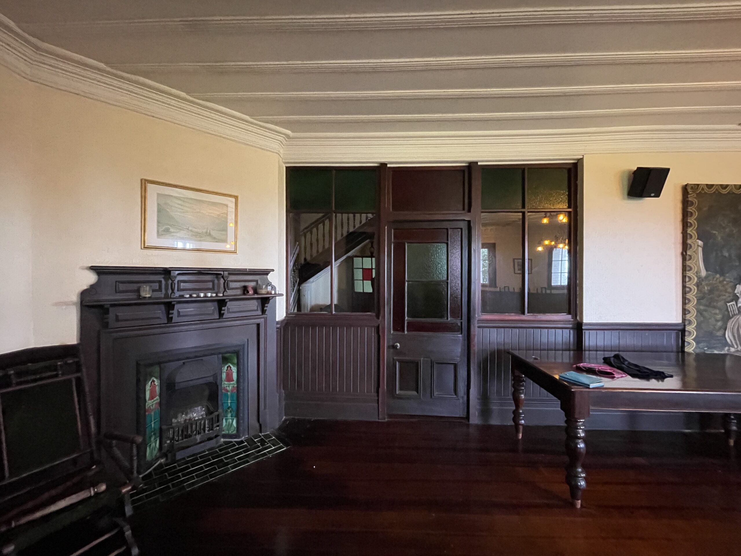
Figure 26: Showing part of the original Billiard Room in the basement, which features an early board and batten ceiling, decorative fireplace and internal timber panelled and glazed screen (C. O’Neil, June 2022).
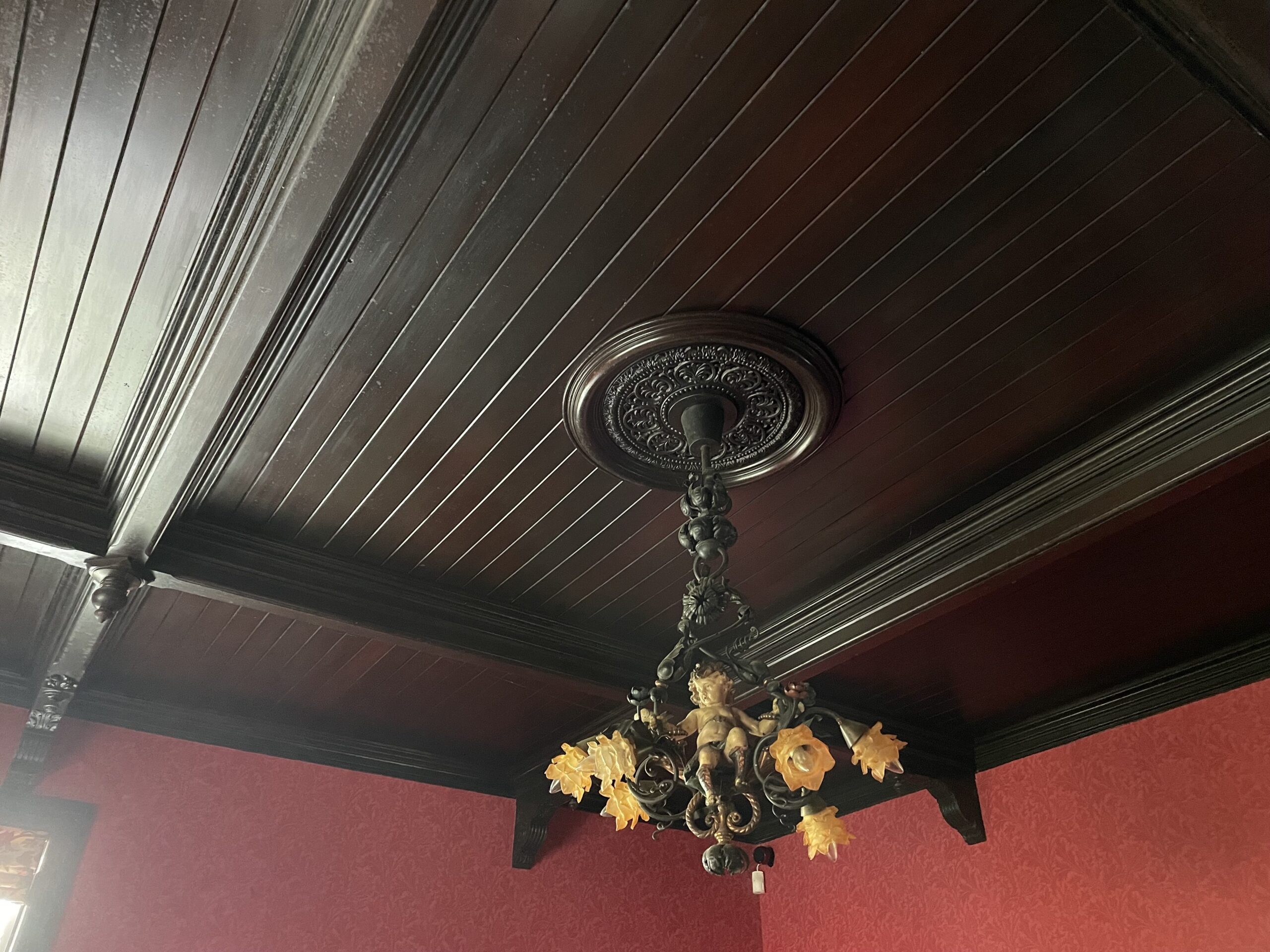
Figure 27: Showing the darkly stained timber beam and panelled ceiling in the Dining Room, with decorative ceiling rose and carved brackets and droppers (C. O’Neil, June 2022).
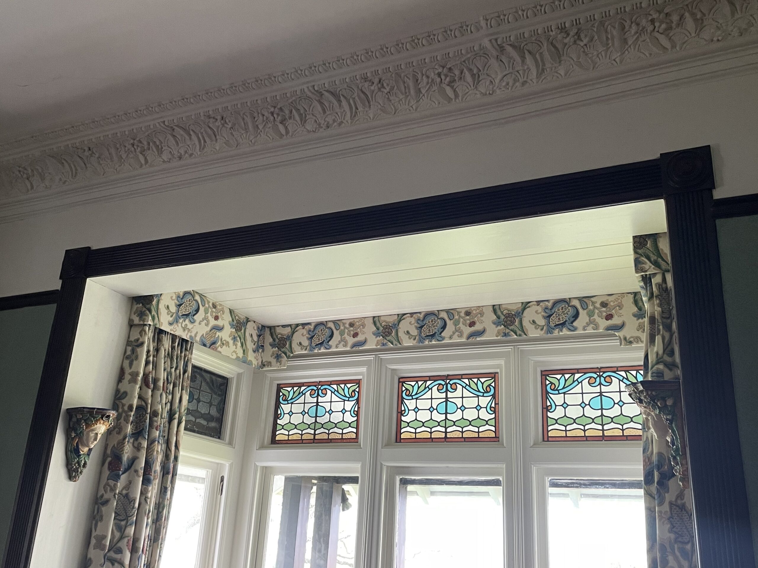
Figure 28: Showing the original box bay window with stained glass top-lights in the Living Room; fluted architraves with roundels; and a highly decorative plaster cornice, which was restored by the current owner (C. O’Neil, June 2022).
Described as “one of the most substantially built brick houses in Auckland”, the dwelling at present-day 231 Remuera Road was built in approximately 1903. It was designed by one of the most prolific architects of the time, Arthur P. Wilson, and showcases an eclectic mix of features reflecting Auckland’s characteristic Victorian and Edwardian villas of the time, as well as hints of the Tudor Revival and Arts and Craft styles through the broad roof, tri-gable dormers and mild timber detailing.
The story
Once described as a ‘magnificent family mansion’ with ‘probably the finest view in the world’, the grand residence formerly known as ‘Capri’ has occupied its location on the slopes of Ōhinerau-Mount Hobson since 1902-3. Designed by well-known architect and Remuera resident, Arthur P. Wilson, the place has important connections with aspects of Auckland’s commercial, social, and religious history, and, at almost 120 years old, has many stories to share.
The house at present-day 231 Remuera Road was built on part of original Allotment 4 of Section 11 of the Suburbs of Auckland, at the corner of Tamaki (present-day Remuera) Road and The Green (now Market) Road (Figure 2).[1] Originally no more than an unformed grass thoroughfare, ‘The Green Road’ was thought to have been named after William Green, a local inn keeper in c.1850.[2]
Measuring just over three and a half acres, Allotment 4 also occupied the south-eastern slopes of Ōhinerau-Mount Hobson (also known as ‘Remuwera’).[3] Believed to be one of Auckland’s best-preserved volcanic cones, Ōhinerau-Mount Hobson was once a Māori pā during which time its slopes (especially those on the steeper eastern side) were terraced for defence, habitation, and agricultural purposes.[4] Its summit offered (and continues to offer) expansive views across the Waitematā Harbour that were once regarded as “preeminent, unequalled, unsurpassed” by John Logan Campbell, who first climbed the maunga in 1840 when scouting land nearby.[5]
Early European land ownership
The Crown grant for Allotment 4 was issued to early settler Philip Kunst (c.1806-1884) in 1847, three years after he had first purchased the land from Māori.[6] Of German origin, Kunst arrived in New Zealand with his wife, Helena, in 1842.[7] A printer by trade, he became the first printer and publisher of the Southern Cross when it was established as one of Auckland’s earliest newspapers in 1843.[8] He subsequently set up his own printing business in Auckland city’s Durham Street, where he held property.[9] Kunst’s ownership of Allotment 4, however, was short-lived. Only 10 months after being issued the Crown grant, he conveyed the land to James Dilworth, a farmer, speculator, philanthropist, and one of early Remuera’s most astute and prosperous landowners.[10]
Born in Northern Ireland, James Dilworth (1815-1894) (Figure 3) spent his early years working on his father’s farm and in a bank. Around 1839, he emigrated first to Australia and then to New Zealand, settling in Auckland in 1841.[11] Working initially for the New Zealand Banking Company as an accountant, he later turned to buying land. By the time the bank closed in 1845, Dilworth had already acquired property in Parnell, Takapuna, and Remuera, with his principal holding comprising around 160 acres between Mount Hobson and Mount St John.[12] Here he developed a suburban farm, which he expanded incrementally over subsequent decades. By 1866, he owned the majority of the land between present-day Remuera, Market, Great South and St Marks roads, in addition to neighbouring land to the east and south (Figure 4). At this time, the three-and-a-half acres of Allotment 4 was used for pasture.
When Dilworth purchased Allotment 4 from Kunst in 1848, he also attempted to acquire 23 acres of neighbouring land, which comprised the upper part of Ōhinerau-Mount Hobson.[13] This land had been set aside by Governor Grey a year earlier as a Government Reserve for ‘public purposes’, but this did not deter Dilworth from initiating a steadfast campaign to secure the prime acreage.[14] Following much resistance from fellow Remuera residents, who petitioned that “under no circumstances should the land itself be alienated from the public”[15], Dilworth was forced to admit defeat. In 1880, the Crown bought Mount Hobson under the Public Domains Act with Brett’s Auckland Almanac proclaiming a year later that “Mount Hobson has, after a hard fight, been gained for the people.”[16]
By this time, Dilworth’s Remuera estate was extensive. Around 23 acres directly southwest of Great South Road was his homestead farm where he had built a spacious residence for himself and his wife, Isabella, grew hay and raised livestock. The remainder and most substantial portion of his farm was leased out in line with patterns of landholding in his native Ireland.[17] At the time of Dilworth’s death in 1894, his estate was valued at £150,000.[18]
As one of the first European farmers in Remuera, Dilworth contributed greatly to the district’s early identity, but his true legacy was realised following his death. With no heir and a long-established love of education, he bequeathed the bulk of his estate to the Dilworth Ulster Institute Trust. The trust was tasked with establishing an institute (or school) to house and educate boys who lived in straitened circumstances.[19] From the beginning of the twentieth century, portions of the estate were progressively subdivided and leases sold, while other allotments continued to be available for lease from the ‘Dilworth Trust Board’.[20]
Lease of Allotment 4
By early 1903, Allotment 4 had been leased from the Dilworth Trust Board by indent and commission agent, Herbert Thompson.[21] The just over three acres of land was held under lease for a term of 99 years, with an annual rent of £60.[22]
Businessman Herbert Thompson (1845-1927) was associated with the soft goods trade first in Australia and then New Zealand.[23] In 1894, he established ‘Herbert Thompson and Co.’, an indent and commission merchants business, which became known for the sale of high quality household and family drapery.[24] By 1899, he had leased land on the corner of Elliot and Darby streets in Auckland’s city centre for the construction of two brick warehouses (present-day ‘Darby Building’).[25] With branches in Auckland, Wellington and Christchurch the business prospered.[26] By all accounts, Thompson’s commercial success enabled him to fund what would later be described as “one of the most substantially built brick houses in Auckland”[27] on his newly-acquired Remuera land.
‘Capri’
Once Herbert Thompson secured the lease for part Allotment 4, he appointed one of Auckland’s most prolific architects, Arthur P. Wilson, to design and supervise the construction of a house on his Mount Hobson property.[28] The substantial two-storey (with basement), 16-roomed residence was “built regardless of expense”, with rendered brick walls, a Marseilles tile roof, and a verandah that extended the length of dwelling’s principal (east) elevation.[29] It reportedly cost £3,500.[30] By March 1903, the Thompsons had moved into their new home, which they had named ‘Capri’.[31,32]
The Architect
Born and educated in London, Arthur Pollard Wilson (1851-1937) (Figure 5) trained under leading architect William Oakley for ten years before setting up on his own account in 1880. Two years later, he immigrated to New Zealand establishing an architectural practice in Auckland.[33] He soon found success designing many of the city’s commercial buildings and has since been credited for the contribution he made to the transformation of Auckland centre’s architecture during the late nineteenth and early twentieth centuries.[34] His earlier commercial work included the design of the Northern Steamship Company building, Quay Street (1898); the Strand Arcade, Queen Street (1899-1900); the aforementioned Darby Building, corner of Elliott and Darby streets (1899-1900); and the A. H. Nathan Warehouse, Customs Street East.[35]
Wilson’s strong commercial connections also led to the design of large suburban homes for a number of his clients, including several notable residences in his own suburb of Remuera. In addition to ‘Capri’ (1902-3), examples included George Nicol’s house at present-day 9 Arney Road (1904); his own house at present-day 84 Victoria Avenue (c.1912); and ‘Roselands’ at present-day 53 Portland Road (1911).[36]
As a parishioner of St Mark’s Church, Wilson also designed its new vicarage on Bassett Road (c.1895), and was later responsible for the design of St Aidan’s Church (1905).[37]
‘The Home Beautiful’
On more than one occasion, Capri was included in a collection of published photographs that showcased some of Auckland’s most well-known and picturesque residences.[38] In one ‘Auckland Weekly News’ feature titled ‘The Home Beautiful’, its photograph sat alongside other notable buildings such as Sir John Logan Campbell’s ‘Kilbryde’ (now demolished) and Mrs Hellaby’s ‘Bramcote’ (Figure 6).[39]
These early photographs of Capri (figures 7 and 8) suggest that the imposing residence had an eclectic architectural style that differed from many of its contemporaries. Its bullnose verandah and box-bay windows with double-hung sash units and stained glass top-lights were characteristic of Auckland’s grand Victorian and Edwardian villas. However, its broad roof and tri-gable dormers with multi-glazed casement windows and mild timber detailing, hint at the Tudor Revival and Arts and Crafts styles. These styles had become increasingly popular in Wilson’s native Britain during the latter part of the nineteenth century and would begin to influence Remuera’s domestic architecture over following decades.
For sale
In 1905, just two years after its completion, Capri was put on the market (Figure 9). By that time, Thompson’s business had gone into liquidation and he was planning to relocate to Christchurch.[40] Between February and April that year, newspapers regularly and enthusiastically publicised the sale of Capri and promoted its many virtues as a “magnificent family residence”, “one of the best known in Auckland”, with “probably the finest panoramic views in the world”.[41,42,43]
Advertised as having large, lofty, and well-proportioned rooms, the ”nearly new” brick residence featured a verandah, balcony, conservatory and a billiard room and was fitted with every modern convenience.[44,45] A nominal ground rent of around £8 was also offered for the land.[46] Thompson’s household furniture and effects, which included a piano, mahogany wardrobe, four hand-painted plaques, and garden tools, were also advertised for sale.[47]
At a public auction on 20 April 1905 Capri was sold for £2,200, much less than the asking price of £3,000.[48,49] By early May, however, the property was again advertised for sale at the reduced rate of £2,500, suggesting that the sale had not gone ahead.[50] The property was finally purchased in July for £2,300 by businessman, George Elliot.[51]
Elliot family home
Born in Jedburgh, Scotland in 1865, George Elliot (1865-1956) (Figure 10) immigrated to New Zealand with his brother, William, in 1891.[52] The brothers initially settled in Tauranga where they ran a newspaper and took up flax milling before relocating to Auckland where they entered into business as agents.[53] In 1897, George married Rachel Winifred (nee. McKerrow) from Dunedin with whom he had three sons – William (b.1898), James (b.1904) and George (b.1907).[54]
When George Elliot acquired Capri in 1905, he was already on his way to becoming an extremely successful and increasingly wealthy businessman. While living at the property, he took on highly influential roles, involved himself in the work of the community, and served on several boards during World War I to support the war effort.[55] By 1919, he had been awarded an OBE and received a knighthood four years later.[56]
Capri was the Elliot family home for approximately 16 years, though they travelled regularly.[57] During that time, a small number of recorded changes were made to the site. Shortly after George Elliot acquired Capri, he sub-leased a portion of land to the south-east to importer and general merchant, J. C. Spedding.[58] A grand residence named ‘Atanga’ (Figure 11) was subsequently built (now demolished) on the site of present-day 9 Market Road.
In 1915, when the first Remuera valuation field sheet was logged, a concrete house and shed, recorded as a ‘porter’s lodge’, had been built at the entrance to the Elliot estate on the corner of Remuera and Market roads.[59] This building still stands today at 233 Remuera Road. At that time, the main residence, still named Capri, was described as a brick and wood house with motor shed and had a capital value of £3,700.[60]
The Elliots left Capri (then addressed 57 Remuera Road) in 1921 following the purchase of another Remuera estate.[61] Their new property comprised a large homestead they named ‘Otimai’ (now demolished) and several acres of land bounded by present-day Benson and Ventnor roads.[62]
Subsequent owners
In 1921, Capri was acquired by company director, Percy Arthur Hadley, whose former home on the corner of Arney and Bell roads had been destroyed by fire earlier that year.[63] His misfortune did not end there. Just months after moving into his new Mount Hobson home, Hadley’s wife, Linda Elizabeth, passed away.[64] Following several unsuccessful business ventures, Hadley filed for bankruptcy and, by 1923, had released his ties to the property.[65] Records indicate that in June that year it was purchased by Engineer, Harold Mason Warner and his wife, Margaret Mary for £5,650.[66] Less than a year later, Capri was acquired by retired businessman, Herbert Mayne Smeeton for £6,250.[67]
H. M. Smeeton
Born in Warwick, England in around 1862, Herbert Mayne (H. M.) Smeeton (c.1862-1927) (Figure 12) moved to New Zealand with his brother, H. W. Smeeton, and settled in Auckland by the late 1880s.[68] In 1891, Smeeton purchased a grocery business on Ponsonby Road, naming it the ‘Household Supply’ store and, by the end of the following year, had relocated to Karangahape Road.[69] With his business flourishing, Smeeton acquired and remodelled a large premises on Queen Street known as ‘The Old Mill’ in 1894, with the purpose of expanding the business and the produce and provisions it offered.[70] With new premises completed in 1912 (present-day 75 Queen Street) (Figure 13), ‘H. M. Smeeton Limited’ became regarded as one of the finest departmental stores in New Zealand.[71] The name of the company was later changed to ‘Smeetons Limited’, with Smeeton retaining a controlling interest until 1917 when, on medical advice, he entered into semi-retirement.[72]
In addition to his commercial endeavours, Smeeton was a well-known figure in the municipal life of Auckland for several years; was active in philanthropic work; and had a prominent association with the Baptist Church.[73]
Alterations, subdivisions and a new name
When Smeeton and his Dunedin-born wife, Sarah Ann, purchased Capri in 1924, its accommodation reportedly comprised a billiard room and smoking room in the basement; a hall, large dining room, sitting room, two bedrooms, kitchen, large pantry, servery and a bathroom on the ground floor; and six bedrooms and a bathroom on the first floor.[74] Soon after their acquisition, Smeeton set about making changes to the dwelling and subdividing the land he leased from the Dilworth Trust Board.
In June 1924, architectural drawings were prepared for alterations and additions to the dwelling (Figure 14).[75] Costing £2,450, works included the construction of a new entrance on the principal elevation, comprising a flat roofed pergola, steps up to a new porch, and the creation of a vestibule in the centre of the existing verandah; the creation of a first-floor balcony on the north elevation; and internal modifications (Figure 15).[76] The Smeetons renamed the residence ‘Binswood’.[77] Possibly deriving from ‘Binswood Hall’, a mid-nineteenth century school for boys in Smeeton’s native Warwickshire, it was a name clearly favoured by the family who had called other residences in their ownership by the same name.[78,79]
In August 1924, a plan was prepared for Smeeton showing the subdivision of the two-acre estate into five lots (Figure 16).[80] Capri occupied Lot 2, which comprised just over an acre of land, and also incorporated Lot 1 to the rear, possibly as an additional garden area. The following year, the lease for lots 3 and 4 (the land upon which 227 Remuera Road now stands) was transferred to solicitor, Hawea Lincoln Rees, while the lease for Lot 5 (present-day 233 Remuera Road) was assigned to solicitor, Spencer Rex Mason.[81] The concrete dwelling known as the porter’s lodge, which occupied Lot 5, was purchased by Mason for £1,650.[82]
Between August 1925 and May 1926, Smeeton travelled overseas in an attempt to improve his health.[83] On his return, preparations were in place for further changes to the property. In August that year, a building permit was granted for the enclosure of a verandah (possibly on the north elevation), which cost £48.[84] By early 1927, another subdivision plan was drawn up to split Lot 2 into two separate parcels.[85] Measuring just over half an acre, the newly-formed parcel of land to the east of Binswood was created for the purpose of erecting a new dwelling (present-day 229 Remuera Road). Designed by well-known architect, Roy A. Lippincott, the new house would enable the Smeetons to down-size while freeing up their larger residence for use by the New Zealand Baptist Church as a long-awaited theological college.[86]
‘College on a hill’
The idea of founding a Baptist college was first formed when Smeeton became president of the Baptist Union of New Zealand in 1923.[87] By early 1926, the New Zealand Baptist Theological College was inaugurated and an anonymous gift of £2,000 had been received towards securing a property for the purposes of building up an educated ministry. With limited options to fundraise the additional money required, Smeeton generously offered up Binswood.[88] Together with six further substantial donations and other gifts from wealthy supporters and church members, the property was handed over free of cost to the Baptist Union in trust for college purposes.[89]
In a January 1927 article documenting the formation of the college and the use of Binswood for that purpose, The New Zealand Baptist wrote:
“A house that has always seemed to us to be the most beautiful for situation in the whole of Auckland city was suddenly, and by a sacrificial impulse of the owner, placed within our reach…It looks out over glorious panorama of hill and sea…If a college had to be designed by an architect the architect would have drawn something more than a little like “Binswood”.
…A broad flight of steps leads to the main entrance. In the basement is a magnificent room which could accommodate 80 people, ideal for library and lecture room. The reception room is very effective in design, and the dining room is ample for our purposes. A suite on the first floor is available for the Principal’s quarters. The kitchen is as large as an institution needs. Upstairs it will be easy to accommodate 15 men. There are fine balconies and outbuildings. There is over an acre of land.”[90]
Binswood was officially opened as Auckland’s first Baptist theological college on 29 February 1928 (Figure 17).[91] Smeeton, who had passed away just four months earlier, did not live to see his long-cherished ambition come into fruition. In tribute to his memory, his wife was asked to perform the opening ceremony by unlocking the door at the commencement of the dedication service (Figure 18).[92]
Classes commenced the following day, and were focussed around training men to become Baptist ministers. The resident college Principal was Reverend John James North (1871-1950).[93] Born in England in 1871, North moved to New Zealand with his family as a child. He was educated in Dunedin and completed his training as a Baptist minister at the University of Otago. He was ordained in 1895.[94] Prior to relocating to Auckland, North ministered in Baptist churches in Christchurch, Oamaru and Wellington and became known for his “popular and fearless preaching”.[95] He served as Principal of the Baptist College and occupied the Mount Hobson building for almost 20 years, during which time he trained a generation of ministers and missionaries. North retired in 1945.[96]
Changes to accommodate a new use
During its time as a Baptist theological college, the residence formerly known as ‘Capri’ and ‘Binswood’ underwent changes to support its continued use. In 1939, a single-storey addition costing £180 was built to the west (rear) elevation to provide a further room off what was then the Kitchen (Figure 23).[97] Seven years later, drawings were prepared by architect, Clifford Sanderson for a small addition and modifications to the northern verandah to accommodate a ‘Boys Room’ and a ‘Girls Room’ (Figure 19). Other works included the removal and repositioning of windows in what was formerly the Study.[98] At that time, the college accommodated between 11 and 13 students in five bedrooms on the first floor, while part of the ground floor was occupied by the Principal and his family.[99]
The residence remained in use as a Baptist college until 1953 when a larger property was acquired at present-day 85 Victoria Avenue for £18,500.[100] Sitting on five acres of land, the new college site provided single student accommodation, married student flats and staff houses.
Subsequent owners and changes
In 1954, the Mount Hobson residence was purchased for £10,000 by Conrad Hobin, who promptly converted the building into five apartments, inhabiting one himself.[101] The property continued to occupy just over an acre of land (comprising Lot 1 and part Lot 2), which Hobin leased from the Dilworth Trust Board.[102]
The lease was renewed in 1975 by Raymond and Julia Noakes and transferred in 1984 to company executive, Peter Uffindell and his wife Jennifer.[103] The Uffindells subsequently purchased the land from the Dilworth Trust Board and went on to subdivide the property into a further four lots.[104] The subject residence stood on Lot 1, which, measuring around a third of an acre (1,402m2), was the largest of the four parcels. Lots 2, 3 and 4, being present-day 231A, 231B and 231C-D Remuera Road respectively, were on-sold and built out by the end of the 1990s.[105]
During the mid-1980s, the subject residence at 231 Remuera Road underwent further changes. Architectural plans were drawn up in 1985 for Kevyn and Susan Male, who occupied the residence as a single family home.[106] Prepared by Carac Design Architects, the plans proposed a new carport in the north-eastern portion of the garden and the construction of a ground floor addition to the north elevation and associated internal modifications to accommodate a new kitchen (Figure 20).[107] The residence changed hands over subsequent decades and was occupied periodically.
When the current owners purchased 231 Remuera Road in 2004, they set about renovating and upgrading the property, which had by then fallen into a state of disrepair.[108] Works included replumbing, rewiring, replastering, sanding the floors, restoring decorative plasterwork and parts of the original staircase, and sourcing and reinstating traditionally-styled fireplaces. In 2010, further changes occurred. New entrance steps were constructed to the east (front) elevation (Figure 21); a two-storey extension was built to the south elevation to accommodate an office and garaging (figures 22 and 23); and a dormer window was installed in the west (rear) roof slope (Figure 24).[109]
As of 2022, the grand residence formerly known as ‘Capri’ is still in use as a single family home. Despite alterations, additions, subdivisions and neighbouring development, the place continues to retain aspects of its traditional layout, fabric and features (figures 26, 27 and 28) and still resembles the imposing building that once stood in isolation on the slopes of Mount Hobson almost 120 years ago.
The Gatehouse to Capri. 233 Remuera Road.
Part of the history of Remuera. Originally built as the Gatehouse for ‘Capri’, the large house at the top of the private road on the eastern boundary.The Gatehouse is featured in many early photos of Mt Hobson and Remuera’s grand houses that were built around the turn of the last century. The architecture is reflective of the period. Built of concrete with a Marseille tiled roof you are well insulated from road. The simple addition of double glazing would give you virtually complete peace.
The layout was designed to make an ‘English Garden’ the focus of the home. The height of the ceilings and proportion of the rooms are a key to the timeless architectural feeling. With a little imagination and a reasonable budget, the Gatehouse could be turned into a charming, character-filled two-bedroom, two living room home, set in a very special garden environment.
Source:https://www.oneroof.co.nz/property/auckland/remuera/233-remuera-road/bipzo?page=alt&mrasn=1597418.1992511.JjVHJc08

Background
The Heritage Studio Limited was commissioned by Remuera Heritage to undertake research to gain an understanding about the history of ‘Capri’ — a grand residence located on the south-eastern slopes of Ōhinerau-Mount Hobson and with extensive views across Remuera and the Waitematā Harbour. The principal aim of the research was to assist in the preparation of a ‘story’ of the place for Remuera Heritage’s ‘Century-Old Homes’ campaign.
Research involved viewing online repositories such as DigitalNZ, Papers Past, and Auckland Libraries resources, sourcing available information at Auckland Council Archives and at Auckland Libraries Research Centre, and viewing deeds indexes, deposit plans, and certificates of title from Archives New Zealand and Land Information New Zealand. It is important to note that opportunities still exist to explore other avenues of research, which may yield more information. Copyright permissions for images have not been gained.
Access onto the site and inside the property was made on 10 June 2022, during which time the current owner kindly showed us around.
Subscribe to our newsletter to keep up to date.
Endnotes
1. Champtaloup and Cooper’s map of the county of Eden, revised by C. Palmer, 1880, Auckland Libraries Heritage Collections Map 190; Winifred Macdonald, ‘Recollections A Sketch History of Early Remuera 1850-1920’, 1984, 6.
2. Winifred Macdonald, 1984, 6; ‘Green Road’, Auckland City Street Names database, Auckland Council Libraries, https://www.aucklandlibraries.govt.nz/Pages/auckland-city-street-names.aspx (accessed 28 June 2022).
3. Auckland Libraries Heritage Collections Map 190; Jenny Carlyon and Diana Morrow, A Fine Prospect: A History of Remuera, Meadowbank and St Johns, Random House, 2011, 20.
4. Jenny Carlyon and Diana Morrow, 2011, 20-1 and 299.
5. Ibid., 20 and 301.
6. Deeds index 3A 2049 and ‘Old land claim plan 376 – Plan of land purchased from the Natives by Philip Kunst, Mount
Hobson’ OLC 376, 1844, Archives New Zealand.
7. Friday, August 15, 1884, Taranaki Herald, Volume XXXII, Issue 6530, 15 August 1884, Papers Past; Roll of early
settlers and descendants in Auckland Province prior to the end of 1852, compiled by Forbes Eadie, annotated with extra information about individuals, Auckland Libraries Heritage Collections b1752637; Death Search ‘Helena Kunst’, Births, Deaths & Marriages Online, https://www.bdmhistoricalrecords.dia.govt.nz/ (accessed 23 June 2022).
8. Friday, August 15, 1884, Taranaki Herald, Volume XXXII, Issue 6530, 15 August 1884, Papers Past; Old Identities – No. 17., Daily Southern Cross, Volume XXXII, Issue 5318, 28 October 1876, Papers Past.
9. Friday, August 15, 1884, Taranaki Herald, Volume XXXII, Issue 6530, 15 August 1884, Papers Past.
10. Deeds index 3A 2049, Archives New Zealand.
11. R. C. J. Stone. ‘Dilworth, James’, Dictionary of New Zealand Biography, first published in 1993. Te Ara – the Encyclopedia of New Zealand, https://teara.govt.nz/en/biographies/2d11/dilworth-james (accessed 26 June 2022); Jenny Carlyon and Diana Morrow, 2011, 46-7.
12. Ibid.
13. Jenny Carlyon and Diana Morrow, 2011, 47-9.
14. Ibid., 48-9 and 299.
15. Memorial of 15 November 1878, n.p., AANS 6095 ACC W5491 1877/1947, Archives New Zealand, cited in Jenny Carlyon and Diana Morrow, 2011, 299.
16. Brett’s Auckland Almanac, Auckland, Henry Brett, 1881, 92, cited in Jenny Carlyon and Diana Morrow, 2011, 49.
17. Jenny Carlyon and Diana Morrow, 2011, 49; R. C. J. Stone. ‘Dilworth, James’,
https://teara.govt.nz/en/biographies/2d11/dilworth-james (accessed 26 June 2022).
18. R. C. J. Stone. ‘Dilworth, James’, https://teara.govt.nz/en/biographies/2d11/dilworth-james (accessed 26 June 2022).
19. Ibid.; Jenny Carlyon and Diana Morrow, 2011, 48 and 53.
20. Deeds index 21A 459, Archives New Zealand; Jenny Carlyon and Diana Morrow, 2011, 249.
21. Dates vary between 1901 and 1903 depending on the source. Remuera Road Board Valuation Rolls, RRB 003 Item No: 2 Page No: 1, 1901, Auckland Council Archives; Page 8 Advertisements Column 3, New Zealand Herald, Volume XLII, Issue 12797, 22 February 1905, Papers Past; Deeds indexes 21A 459 and 5A 616, Archives New Zealand.
22. Page 8 Advertisements Column 3, New Zealand Herald, Volume XLII, Issue 12797, 22 February 1905, Papers Past.
23. Veteran Solicitor, New Zealand Herald, Volume LXIV, Issue 19644, 24 May 1927, Papers Past.
24. Music, Mirth. And Monody., New Zealand Herald, Volume XXXI, Issue 9671, 17 November 1894, Papers Past; Page 11 Advertisements Column 1, New Zealand Times, Volume XXVII, Issue 5605, 3 June 1905, Papers Past.
25. Page 2 Advertisements Column 3, Auckland Star, Volume XXX, Issue 172, 22 July 1899, Papers Past; Auckland Council, Heritage Evaluation: Darby Building, May 2017.
26. Untitled, Manawatu Standard, Volume XXXVIII, Issue 6869, 7 December 1900, Papers Past; Page 11 Advertisements Column 1, New Zealand Times, Volume XXVII, Issue 5605, 3 June 1905, Papers Past.
27. Untitled, Auckland Star, Volume XXXVI, Issue 92, 18 April 1905, Papers Past.
28. Page 8 Advertisements Column 8, Auckland Star, Volume XXXIII, Issue 143, 18 June 1902, Papers Past; Page 6 Advertisements Column 4, New Zealand Herald, Volume XLII, Issue 12812, 11 March 1905, Papers Past.
29. Page 8 Advertisements Column 4, Auckland Star, Volume XXXVI, Issue 90, 15 April 1905, Papers Past; Page 1 Advertisements Column 4, Auckland Star, Volume XXXVI, Issue 165, 12 July 1905, Papers Past.
30. Sale of a Mansion, New Zealand Herald, Volume XLII, Issue 12847, 22 April 1905, Papers Past.
31. In March 1903, Mrs Herbert Thompson was advertising for a ‘Good General Servant’, suggesting the house was occupied at this time. It is not known whether the Thompsons had any children.
32. Page 1 Advertisements Column 8, New Zealand Herald, Volume XL, Issue 12228, 25 March 1903, Papers Past; Page 1 Advertisements Column 5, New Zealand Herald, Volume XLII, Issue 12793, 17 February 1905, Papers Past.
33. Architects Death, New Zealand Herald, Volume LXXIV, Issue 22875, 2 November 1937, Papers Past; Cyclopedia Company Limited, The Cyclopedia of New Zealand [Auckland Provincial District: Wilson, Arthur P., Christchurch, 1902, New Zealand Electronic Text Collection, https://nzetc.victoria.ac.nz/tm/scholarly/tei-Cyc02Cycl-t1-body1-d1-d34- d10.html (accessed 10 June 2022); Page 3 Advertisements Column 6, Auckland Star, Volume XXVI, Issue 4487, 3 October 1884, Papers Past.
34. Heritage New Zealand Pouhere Taonga, Strand Arcade, 233-237 Queen Street, Elliot Street, Auckland, List Number 123, https://www.heritage.org.nz/the-list/details/123 (accessed 5 July 2022).
35. Ibid.; Architects Death, New Zealand Herald, Volume LXXIV, Issue 22875, 2 November 1937, Papers Past; Cyclopedia Company Limited, The Cyclopedia of New Zealand [Auckland Provincial District: Wilson, Arthur P., Christchurch, 1902, New Zealand Electronic Text Collection, https://nzetc.victoria.ac.nz/tm/scholarly/tei-Cyc02Cycl-t1-body1-d1- d34-d10.html (accessed 10 June 2022); Jenny Carlyon and Diana Morrow, 2011, 254.
36. Jenny Carlyon and Diana Morrow, 2011, 254 and 257-8; Page 5 Advertisements Column 2, New Zealand Herald, Volume XXXII, Issue 9818, 13 May 1895, Papers Past.
37. Jenny Carlyon and Diana Morrow, 2011, 254.
38. ‘Some pretty dominion homes’, taken from the NZ Graphic, 20 January 1909, p26, Sir George Grey Special
Collections, Auckland Libraries, NZG-19090120-26-1 (accessed 13 June 2022); ‘The home beautiful’, taken from the supplement to the Auckland Weekly New, 8 January 1914, p49, Auckland Libraries Heritage Collections AWNS- 19140108-49-1 (accessed 13 June 2022).
39. ‘The home beautiful’, taken from the supplement to the Auckland Weekly New, 8 January 1914, p49, Auckland Libraries Heritage Collections AWNS-19140108-49-1 (accessed 13 June 2022).
40. Page 8 Advertisements Column 3, Auckland Star, Volume XXXVI, Issue 56, 7 March 1905, Papers Past.
41. Page 8 Advertisements column 4, Auckland Star, Volume XXXVI, Issue 90, 15 April 1905, Papers Past.
42. Sale of a Mansion, New Zealand Herald, Volume XVII, Issue 12847, 22 April 1905, Papers Past.
43. Untitled, Auckland Star, Volume XXXVI, Issue 92, 18 April 1905, Papers Past.
44. Page 8 Advertisements Column 3, New Zealand Herald, Volume XLII, Issue 12797, 22 February 1905, Papers Past.
45. Page 8 Advertisements Column 1, New Zealand Herald, Volume XLII, Issue 12844, 18 April 1905, Papers Past.
46. Untitled, Auckland Star, Volume XXXVI, Issue 92, 18 April 1905, Papers Past.
47. Page 6 Advertisements Column 4, New Zealand Herald, Volume XLII, Issue 12812, 11 March 1905, Papers Past; Page 8 Advertisements Column 1, New Zealand Herald, Volume XLII, Issue 12815, 15 March 1905, Papers Past.
48. Untitled, Auckland Star, Volume XXXVI, Issue 94, 20 April 1905, Papers Past; Sale of a Mansion, New Zealand Herald, Volume XVII, Issue 12847, 22 April 1905, Papers Past.
49. Page 1 Advertisements Column 4, New Zealand Herald, Volume XLII, Issue 12834, 6 April 1905, Papers Past.
50. Page 1 Advertisements Column 4, Auckland Star, Volume XXXVI, Issue 105, 3 May 1905, Papers Past; Page 1 Advertisements Column, Auckland Star, Volume XXXVI, Issue 165, 12 July 1905, Papers Past.
51. Untitled, Auckland Star, Volume XXXVI, Issue 162, 8 July 1905, Papers Past.
52. Former Head of Bank of NZ, Press, Volume XCIII, Issue 28003, 25 June 1956, Papers Past.
53. Ibid.; ‘The Life and Times of Sir George Elliot’, Sir George Elliot Charitable Trust, http://www.elliottrust.org.nz/about-the-trust/sir-george-elliot/ (accessed 10 June 2022).
54. Marriage and birth searches, Births, Deaths & Marriages Online, https://www.bdmhistoricalrecords.dia.govt.nz/ (accessed 7 July 2022); Births, New Zealand Herald, Volume XLIV, Issue 13473, 27 April 1907, Papers Past.
55. Former Head of Bank of NZ, Press, Volume XCIII, Issue 28003, 25 June 1956, Papers Past; ‘The Life and Times of Sir George Elliot’, Sir George Elliot Charitable Trust, http://www.elliottrust.org.nz/about-the-trust/sir-george-elliot/ (accessed 10 June 2022).
56. Ibid.
57. Mr and Mrs George Elliot were recorded in the newspapers as regularly travelling either within New Zealand or overseas during this time.
58. Deeds index 5A 616, Archives New Zealand; Obituary, Auckland Star, Volume LXXI, Issue 146, 21 June 1940, Papers Past.
59. ACC 213 Valuation Field Sheets 1912-1997, Remuera Road 1-291, Record ID: 329082, Auckland Council Archives.
60. Ibid.
61. Ibid.; Deeds index 5A 616, Archives New Zealand.
62. News of the Day, New Zealand Times, Volume XLII, Issue 9693, 22 June 1917, Papers Past; Certificate of Title 15/186, LINZ records; Page 14 Advertisements Column 2, Auckland Star, Volume LVI, Issue 275, 20 November 1925, Papers Past.
63. ACC 213 Valuation Field Sheets 1912-1997, Remuera Road 1-291, Record ID: 329082, Auckland Council Archives; Deeds index 5A 616, Archives New Zealand; Destroyed by Fire, Auckland Star, Volume LII, Issue 6, 7 January 1921, Papers Past.
64. Page 12 Advertisements Column 1, Auckland Star, Volume LII, Issue 218, 13 September 1921, Papers Past.
65. Page 1 Advertisements Column 4, New Zealand Herald, Volume LIX, Issue 18173, 19 August 1922, Papers Past; Oil Share Ventures, New Zealand Herald, Volume LXI, Issue 18696, 30 April 1924, Papers Past; Page 3 Advertisements Column 4, New Zealand Herald, Volume LXI, Issue 18710, 16 May 1924, Papers Past.
66. ACC 213 Valuation Field Sheets 1912-1997, Remuera Road 1-291, Record ID: 329082, Auckland Council Archives; Deeds index 6A 210, Archives New Zealand; Certificate of Title NA513/17, Land Information New Zealand records.
67. Ibid.
68. Obituary, Poverty Bay Herald, Volume LIII, Issue 16489, 5 November 1927, Papers Past; Untitled, New Zealand Herald, Volume XXV, Issue 9211, 14 November 1888, Papers Past.
69. Page 8 Advertisements Column 4, Auckland Star, Volume XXII, Issue 177, 28 July 1891, Papers Past; Page 7 Advertisements Column 2, Bay of Plenty Times, Volume XXI, Issue 2896, 21 October 1892, Papers Past.
70. “The Old Mill”, Auckland Star, Volume XXV, Issue 258, 29 October 1894, Papers Past; Finance and commerce., Press, Volume LXVIII, Issue 20560, 31 May 1932, Papers Past; Page 1 Advertisements Column 4, New Zealand Herald, Volume XXXI, Issue 9593, 18 August 1894, Papers Past.
71. Page 1 Advertisements Column 4, New Zealand Herald, Volume XXXI, Issue 9593, 18 August 1894, Papers Past; Land and Buildings., New Zealand Herald, Volume XLIX, Issue 14951, 26 March 1912, Papers Past; Personal Matters, Evening Post, Volume CIV, Issue 106, 1 November 1927, Papers Past.
72. Personal Matters, Evening Post, Volume CIV, Issue 106, 1 November 1927, Papers Past.
73. Mr. Herbert Smeeton., Auckland Star, Volume LVIII, Issue 257, 31 October 1927, Papers Past; Obituary, Press, Volume LXIII, Issue 19146, 1 November 1927, Papers Past.
74. Mrs S. A. Smeeton, Otago Daily Times, Issue 27122, 2 July 1949, Papers Past; ACC 213 Valuation Field Sheets 1912-1997, Remuera Road 1-291, Record ID: 329082, Auckland Council Archives.
75. AKC 339 Building Permit and Consents Aperture Cards 1908-1997, Remuera Road (up to 519), Record ID: 178633, Auckland Council Archives; AKC 338 Building Consents Mircrofilm 1908-1908, Remuera Road, Record ID: 520413, Auckland Council Archives.
76. Ibid.; ACC 213 Valuation Field Sheets 1912-1997, Remuera Road 1-291, Record ID: 329082, Auckland Council Archives.
77. The College. A Dream Fulfilled, The New Zealand Baptist, 43rd year of issue, no. 467, January 1927, 2.
78. Historic England, Binswood Hall (School), Royal Leamington Spa, Warwickshire,
https://historicengland.org.uk/services-skills/education/educational-images/binswood-hall-school-royal-leamington-spa-5294 (accessed 11 July 2022).
79. The Smeetons owned a residence named ‘Binswood’ in both View Road, Mount Eden and in Manurewa. Page 1
Advertisements Column 5, Auckland Star, Volume XXIX, Issue 259, 2 November 1898, Papers Past; Local and
General, Ashburton Guardian, Volume 49, Issue 10, 24 October 1928.
80. Deed 959, Land Information New Zealand records.
81. Certificate of title NA513/17, Land Information New Zealand records.
82. ACC 213 Valuation Field Sheets 1912-1997, Remuera Road 1-291, Record ID: 329082, Auckland Council Archives.
83. Back From Tour., Auckland Star, Volume LVII, Issue 122, 25 May 1926, Papers Past.
84. ACC 213 Valuation Field Sheets 1912-1997, Remuera Road 1-291, Record ID: 329082, Auckland Council Archives.
85. Deed 1192, Land Information New Zealand records.
86. Ibid.; The College. A Dream Fulfilled, The New Zealand Baptist, 43rd year of issue, no. 467, January 1927, 2; Martin Sutherland and Laurie Guy, An Unfolding Story: A History of Carey Baptist College, Archer Press NZ, 2014, 27.
87. Personal., Timaru Herald, Volume XCVIII, Issue 18084, 20 October 1923, Papers Past.
88. The Baptist College., New Zealand Herald, Volume LXIII, Issue 19267, 4 March 1926, Papers Past; The College. A Dream Fulfilled, The New Zealand Baptist, 43rd year of issue, no. 467, January 1927, 2; Martin Sutherland and Laurie Guy, An Unfolding Story: A History of Carey Baptist College, Archer Press NZ, 2014, 27.
89. Ibid.
90. The College. A Dream Fulfilled, The New Zealand Baptist, 43rd year of issue, no. 467, January 1927, 2.
91. Training Ministers., New Zealand Herald, Volume LXV, Issue 19884, 1 March 1928, Papers Past; Baptist College Opened Yesterday, Sun (Auckland), Volume I, Issue 292, 1 March 1928, Papers Past.
92. Ibid.; The Opening of The New Baptist Theological College at Remuera., New Zealand Herald, Volume LXV, Issue 19884, 1 March 1928, Papers Past.
93. Training Ministers., New Zealand Herald, Volume LXV, Issue 19884, 1 March 1928, Papers Past; Baptist College Opened Yesterday, Sun (Auckland), Volume I, Issue 292, 1 March 1928, Papers Past; Angus MacLeod. ‘North, John James’, Dictionary of New Zealand Biography, first published in 1996. Te Ara – the Encyclopedia of New Zealand, https://teara.govt.nz/en/biographies/3n11/north-john-james (accessed 15 July 2022).
94. Angus MacLeod. ‘North, John James’, Dictionary of New Zealand Biography, first published in 1996. Te Ara – the Encyclopedia of New Zealand, https://teara.govt.nz/en/biographies/3n11/north-john-james (accessed 15 July 2022).
95. Ibid.
96. Ibid.
97. AKC 339 Building Permit and Consents Aperture Cards 1908-1997, Remuera Road (up to 519), Record ID: 178633, Auckland Council Archives; AKC 338 Building Consents Mircrofilm 1908-1908, Remuera Road, Record ID: 520413, Auckland Council Archives; ACC 213 Valuation Field Sheets 1912-1997, Remuera Road 1-291, Record ID: 329082, Auckland Council Archives.
98. AKC 339 Building Permit and Consents Aperture Cards 1908-1997, Remuera Road (up to 519), Record ID: 178633, Auckland Council Archives; AKC 338 Building Consents Mircrofilm 1908-1908, Remuera Road, Record ID: 520413, Auckland Council Archives.
99. AKC 338 Building Consents Mircrofilm 1908-1908, Remuera Road, Record ID: 520413, Auckland Council Archives.
100. New Zealand Baptist Theological College, National Library, https://natlib.govt.nz/records/22375238 (accessed 17 July 2022).
101. ACC 213 Valuation Field Sheets 1912-1997, Remuera Road 1-291, Record ID: 329082, Auckland Council Archives; AKC 339 Building Permit and Consents Aperture Cards 1908-1997, Remuera Road (up to 519), Record ID: 178633, Auckland Council Archives.
102. Certificate of Title NA1151/68, Land Information New Zealand records.
103. Ibid.
104. Ibid.; Certificate of Title NA70B/272 and Deposit Plan 120996, Land Information New Zealand records.
105. Based on a 1996 aerial photograph, Auckland Council GeoMaps.
106. Certificates of title NA1151/68 and NA70B/272, Land Information New Zealand records; AKC 339 Building Permit and Consents Aperture Cards 1908-1997, Remuera Road (up to 519), Record ID: 178633, Auckland Council Archives; AKC 338 Building Consents Mircrofilm 1908-1908, Remuera Road, Record ID: 520413, Auckland Council Archives.
107. AKC 339 Building Permit and Consents Aperture Cards 1908-1997, Remuera Road (up to 519), Record ID: 178633, Auckland Council Archives; AKC 338 Building Consents Mircrofilm 1908-1908, Remuera Road, Record ID: 520413, Auckland Council Archives.
108. Pers. comm. owner of 231 Remuera Road, 10 June 2022.
109. Ibid.
Related Stories
RETURN TO TOP
