Vallombrosa: A Lost Remuera Estate
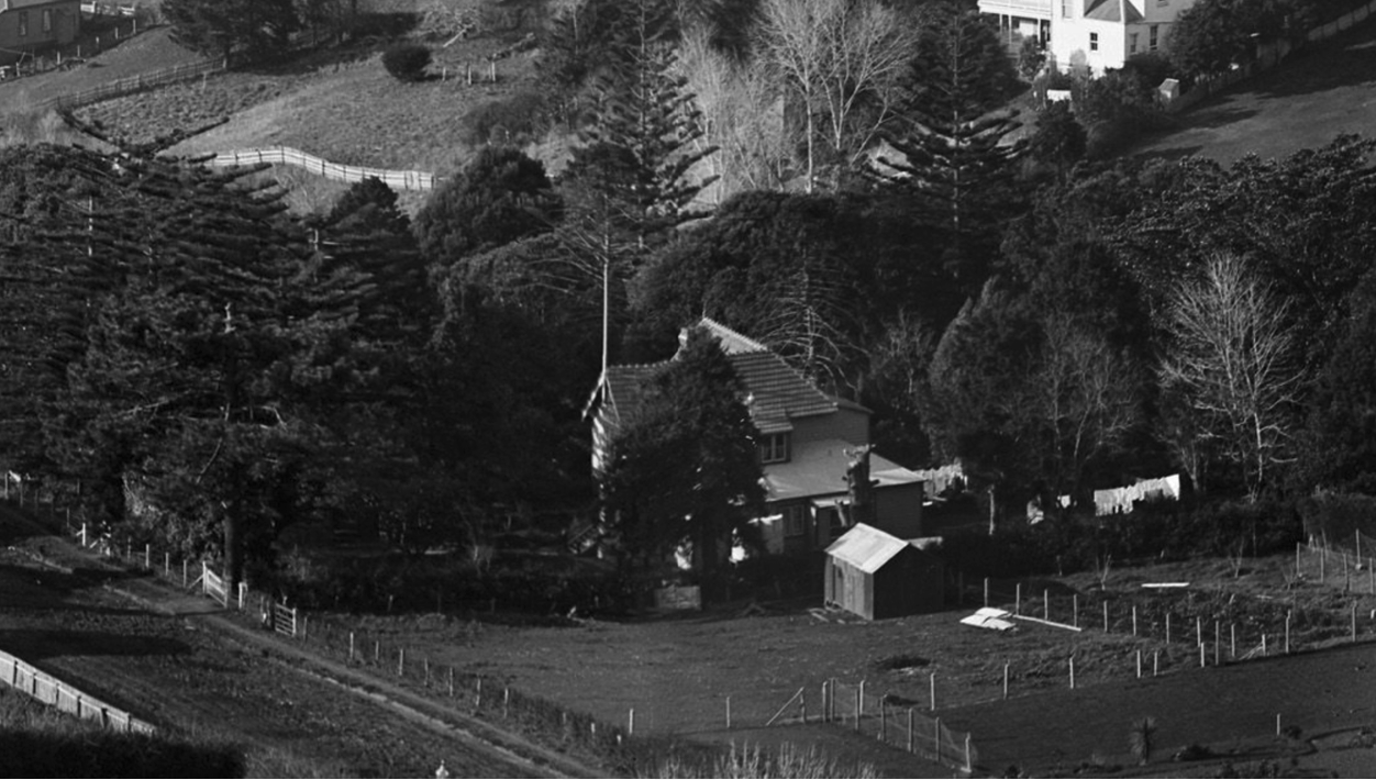

Figure 1: Vallombrosa on Westbourne Road in 1904 (Cropped image of panoramic photograph showing a Remuera from Mount Hobson, Auckland Libraries Heritage Collections 1-W1140-PAN).
Background
Remuera Heritage commissioned The Heritage Studio Limited to prepare a historical narrative documenting the former residence known as ‘Vallombrosa’, which once stood at present-day 15 Westbourne Road, Remuera.
Research for this work drew on online repositories such as DigitalNZ, Papers Past, and Auckland Libraries resources; material held at Auckland Council Archives; and early deeds indexes and certificates of title from Land Information New Zealand (LINZ). Opportunities exist to pursue additional avenues of research, which may yield further detail.
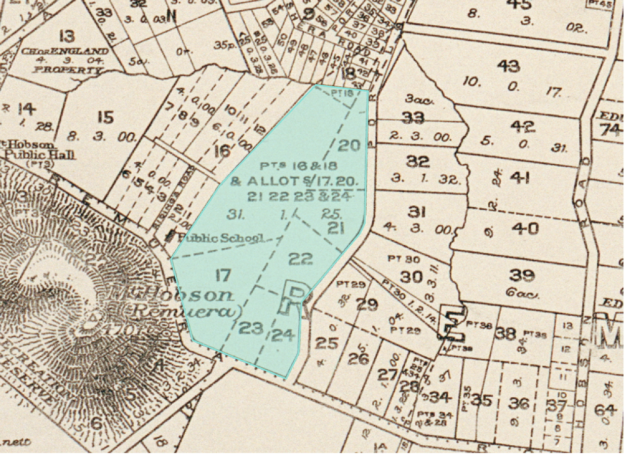
Figure 2: (Top) Sheet 4 of a cadastral map of Eden County (Auckland City) showing original sections and subdivisions, 1892 (Auckland Libraries Heritage Collections Map 4658). (Above) Close-up extract of map showing original allotments 9, 16-18, 20-24 of Section 16 Suburbs of Auckland (highlighted) that had formerly been part of Grahame’s Farm and Williamson’s estate.
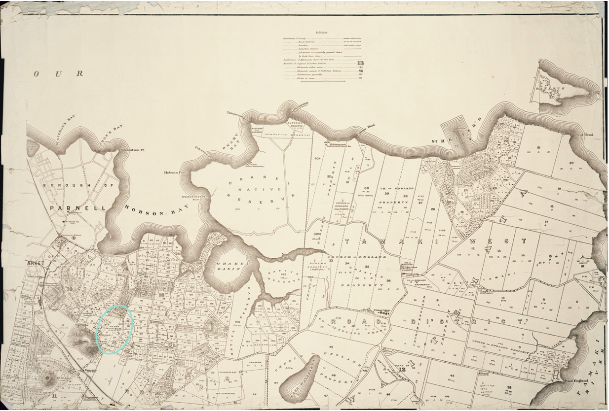
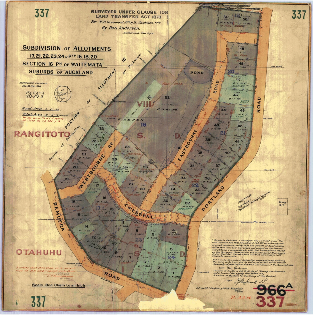
Figure 3: (Above) Deposit Plan 337, showing the subdivision of original allotments into 52 lots and the formation of Westbourne Road, Eastbourne Road and Crescent (now Westbury Crescent) for R. C. Greenwood and S. Jackson, 1885 (DP 337, Land Information New Zealand).
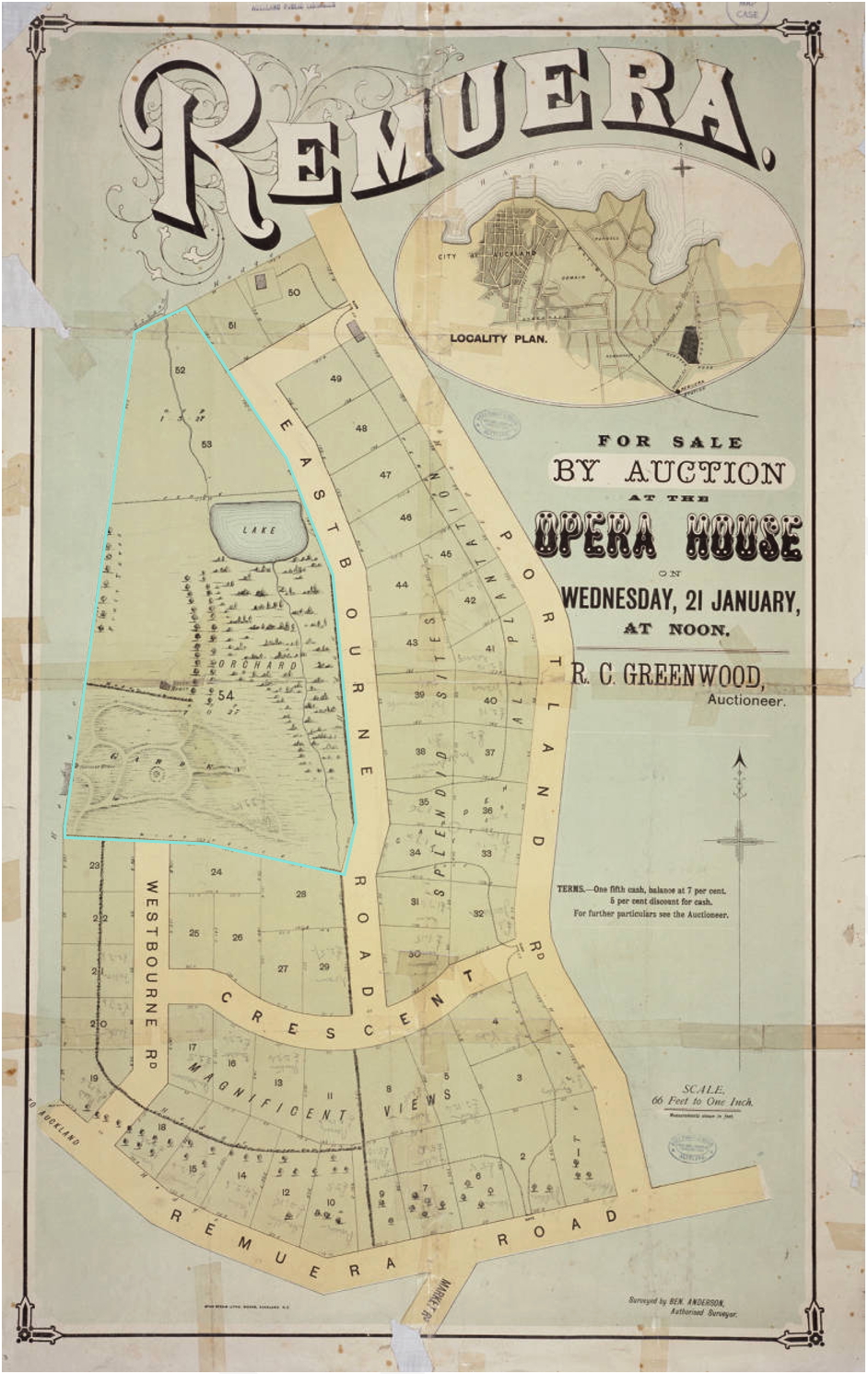
Figure 4: Advertisement showing the subdivision for sale in 1885. Lot 52 (shown here as 52-54) is much larger than other lots and comprises an already established estate with formal garden, orchard and a lake (outlined) (Auckland Libraries Heritage Collections Map 2675).
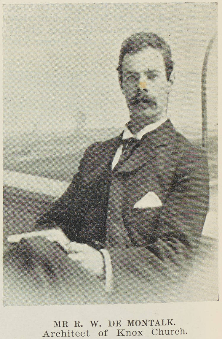
Figure 5: Mr R. W. De Montalk, published in The New Zealand Graphic and Ladies Journal, 17 June 1899, p.822 (Auckland Libraries Heritage Collections NZG-18990617-0822-04).
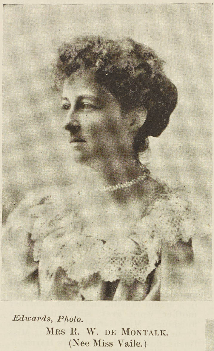
Figure 6: Mrs R. W. De Montalk (nee Miss Vaile), published in The New Zealand Graphic and Ladies Journal, 12 March 1898, p.323 (Auckland Libraries Heritage Collections NZG-18980312-0323-01).
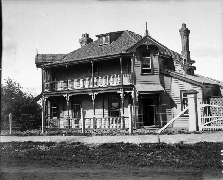
Figure 7: ‘Twyford’ 21 Arney Road, 1906, a year after it was completed for Samuel Vaile. Designed by his son-in-law, Robert de Montalk, the place shared architectural similarities with de Montalk’s own home, Vallombrosa (Auckland Libraries Heritage Collections 2-V1191).
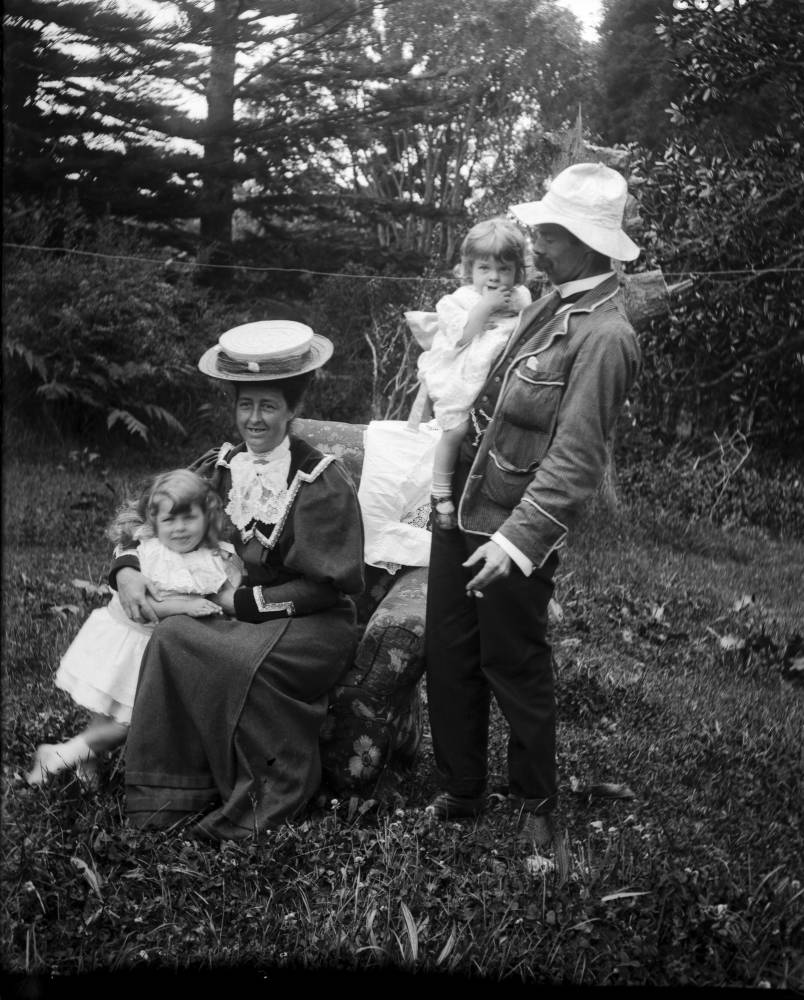
Figure 8: The de Montalk family in the garden at Vallombrosa, 1906. Anne Maud is hugging Geoffrey and her husband, Robert de Montalk, is holding Cedric. The boys’ clothes were designed by their mother (photographer Hubert Earle Vaile, 1906, Auckland Libraries Heritage Collections 2-V1235).
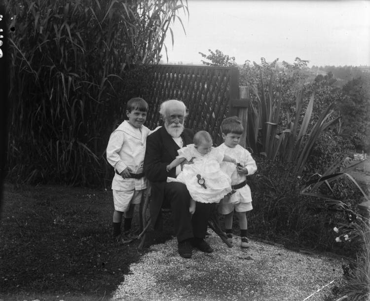
Figure 9: Samuel Vaile with his grandchildren, Geoffrey (left), Cedric (right) and Dulce de Montalk in the garden of the Vaile family home, Twyford on Arney Road, 1909 (photographer Hubert Earle Vaile, 1909, Auckland Libraries Heritage Collections 2-V1136).
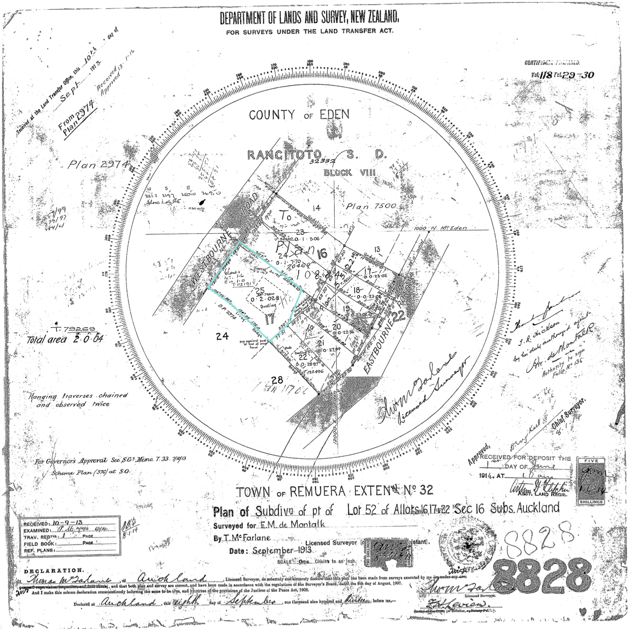
Figure 10: Deposit Plan 8828 showing the 1913 subdivision of the southern portion of the Vallombrosa estate. Vallombrosa (outline shown on map) occupied Lot 25 of the new subdivision (outlined) (DP 8828, Land Information New Zealand).
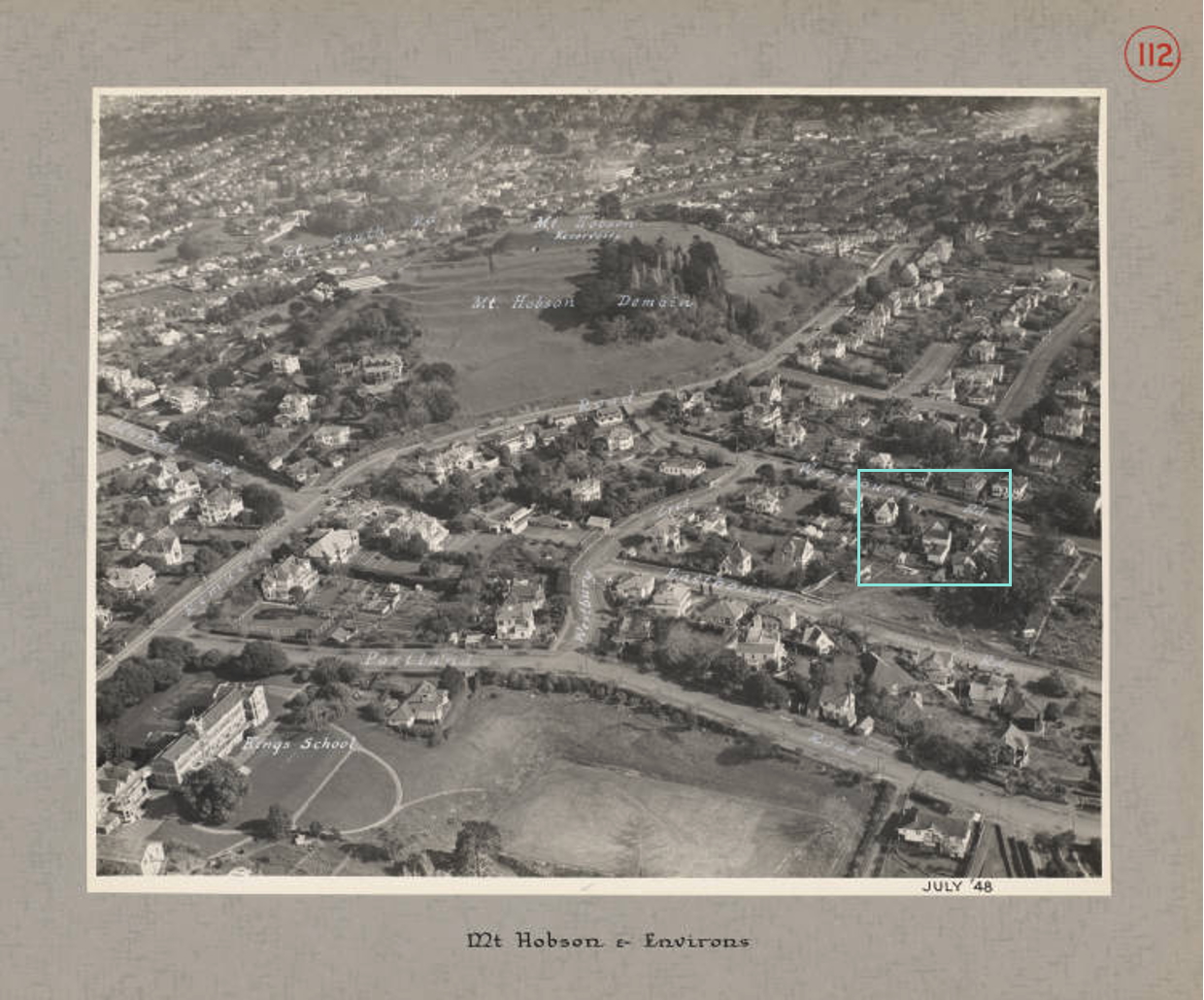
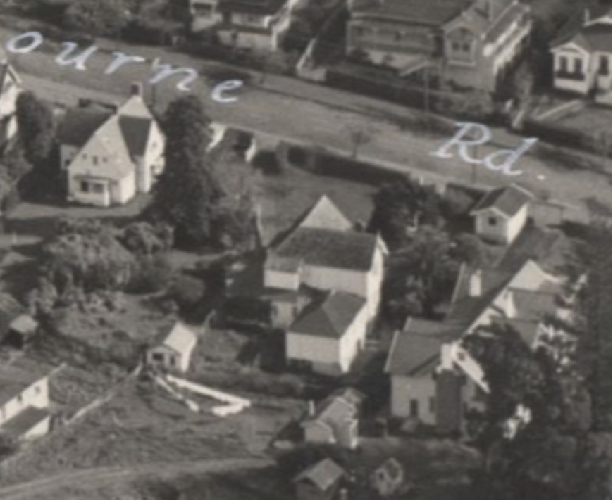
Figure 11: (Above) Aerial view of Mount Hobson and Environs, 1948, Map 112 (Whites Aviation Collection, Alexander Turnbull Library, Auckland Libraries Heritage Collections 580-ALB22-112) (Left) Close-up of aerial image, showing the rear of Vallombrosa (centre).
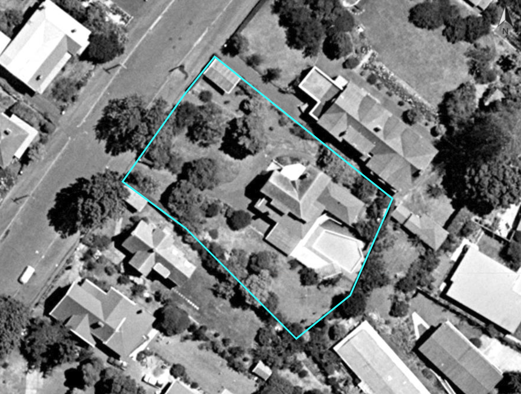
Figure 12: Aerial image of Vallombrosa at 15 Westbourne Road, 1970s, showing an addition to the south and swimming pool to the rear (Auckland Council GeoMaps Aerial Photography 1970s).
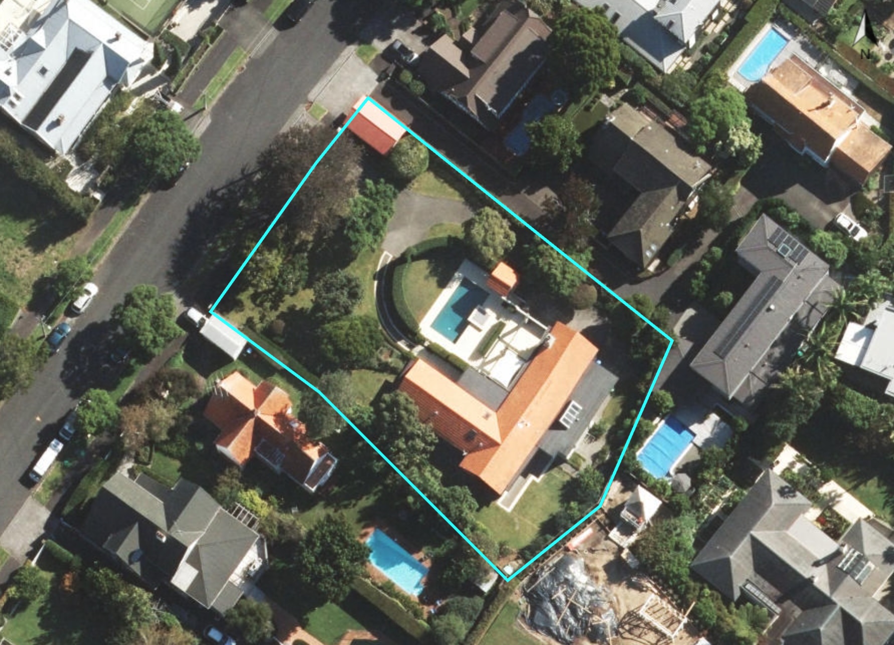
Figure 13: Aerial image of the new modern residence at 15 Westbourne Road, 2024-25, showing the 1920s garage that remains at the front boundary (Auckland Council GeoMaps Aerial Photography 2024 and 2025).
Vallombrosa: A Lost Remuera Estate
On the northern slopes of Remuera, Vallombrosa emerged as a grand villa set within nine acres of gardens and trees, built as a creative and cultivated home for the de Montalk family. Over time, the estate was reshaped by subdivision, new owners, and the pressures of a developing suburb. What remains is its story – a thread woven through the evolution of Westbourne Road and the Remuera seen today.
The land upon which Vallombrosa would later stand formed part of the ‘Ōhinerau’ blocks, expansive areas of Crown-purchased land on the northern slopes of Remuera acquired from Ngāti Whātua between 1851 and 1853. Quickly recognised as “some of the most valuable land in Remuera,”[1] the blocks attracted intense competition at auction and generated substantial profit for the Crown.[2]
Among the earliest purchasers were Auckland merchant and land speculator William Smellie Grahame (1813-1894) and his wife Anne.[3] Between 1852 and 1854, they acquired a large holding that became known locally as ‘Grahame’s Farm’.[4] At this time, Remuera was predominantly rural, characterised by scattered homesteads, small farms, and broad tracts of undeveloped land. The scale of the Grahame property reflected both his own prosperity and the confidence of Auckland’s early colonial period.
Grahame’s Farm remained largely intact until 1870, when almost 50 acres were sold to influential businessman James Williamson (1814-1888).[5] Comprising Allotments 9, 16-18, 20-24 of Section 16 Suburbs of Auckland, the landholding was roughly bounded by today’s Remuera, Westbourne, and Portland Roads (Figure 2).[6] By the mid-1880s, the property had been transformed into a landscaped country estate, fenced, planted, and offering expansive views.[7]
Subdivision and the Creation of Lot 52
In 1885, financial difficulties prompted Williamson to sell the estate to land agent Robert Charles Greenwood and solicitor Samuel Jackson.[8] The 31-acre property was promptly subdivided into more than 50 sites laid out along Remuera Road, Portland Road, and the newly-formed Westbourne Road, Eastbourne Road, and the Crescent (present-day Westbury Crescent) (Figure 3).[9] Marketed as “the pick of the district”, the subdivision offered villa sites and excellent views.[10]
Most lots measured just over a quarter of an acre, but one – Lot 52 – was far more substantial. At more than nine acres, it contained an established landscape of formal gardens, an orchard, a pond, a summer house, and a modest stone house (Figure 4).[11] Greenwood held the title until 1887, when it transferred to mortgagee John Edward Elam.[12] After Elam’s death in 1888, Lot 52 passed into his estate and remained under trusteeship until 1903 when portions were sold to new owners. Among them were real estate agent Edward Earle Vaile and his brother-in-law, architect Robert Wladislas de Montalk, a partnership that would soon give rise to Vallombrosa.[13]
The de Montalk and Vaile Families
Robert Wladislas de Montalk (1871-1942) (Figure 5) was born in Featherston, the son of Joseph Wladislas Edmond Potocki de Montalk (1836-1901), a Paris-born scholar of Polish noble descent, and his second wife, Alexandrina Williamina Sutherland Macalister.[14] Edmond became a prominent teacher of European languages, a celebrated lecturer at Auckland University College, and founded the first local branch of the Alliance Française.[15] Robert grew up in a cosmopolitan, intellectually orientated household shaped by European scholarship, multilingualism, and a strong cultural identity.
After training under Christchurch architect Frederick Strouts, Robert established his own practice in Auckland in 1895. His early commissions – including Knox Presbyterian Church (1899) in Parnell and ‘Riverina’ (1901) in Warkworth – demonstrated both competence and innovation, the latter being an early example of concrete construction. His appointment as honorary architect to the Auckland Industrial and Mining Exhibition during the early years of his career also elevated his profile.[16]
In 1898, Robert married Annie Maud Vaile (1867-1908) (Figure 6), eldest daughter of prosperous merchant and land agent Samuel Vaile (1828-1913) and his wife Sarah.[17] Annie, an accomplished artist trained at the Auckland Society of Arts, widely exhibited her paintings of New Zealand landscapes.[18] When Robert and Annie’s brother, Edward, acquired adjoining parts of Lot 52 in 1903, the Vaile portion was likely provided as Annie’s dowry. It was on this land that the de Montalks built their family home, Vallombrosa.[19]
Building Vallombrosa
Occupying more than nine acres of Lot 52, the Vallombrosa estate was already well established, having been part of an landscaped property developed before 1885. Tenders for the construction of a residence on Westbourne Road, designed by Robert, were advertised in late 1902.[20] By 1903, Vallombrosa was completed.[21]
Early photographs show a generous two-storey timber villa with a tiled roof, projecting gables to the north and west, a chamfered corner entrance, lean-tos, and a large, single-storey rear wing – possibly added later (Figure 1). The interior contained around seven rooms, including a ballroom spacious enough to host formal social gatherings. One such “At Home” event was documented in a 1906 article, which described the ballroom as “tastefully decorated with festoons of lycopodium and mirrors draped with flags.”[22]
Robert and Annie’s first son, Geoffrey Wladislas, was born in 1903, followed by Cedric Earle in 1905, and Dulce Maud in 1908.[23] Geoffrey later recalled these early years at Vallombrosa as ‘The Golden Idyll’.[24]
Around this time, Samuel Vaile relocated from his Karangahape Road residence, ‘The Avenue’, to Remuera, commissioning Robert to design ‘Twyford’, a large residence on Arney Road.[25][26] Completed in 1905, the two-storey timber villa shared architectural similarities with Vallombrosa (Figure 7). Contemporary photographs taken by Samuel’s son, Hubert Earle Vaile (1876-1936), document family life in both Vallombrosa and Twyford (Figure 8 and Figure 9).
A Changing Household
Annie’s death in 1908 brough a sudden and profound change to life at Vallombrosa, ending the estate’s early period of optimism and family creativity.[27] For Robert, now a widower with three young children, the years that followed were marked by both personal adjustment and professional continuity. His architectural practice remained active, and he continued to contribute to Auckland’s built environment during a period of rapid urban and suburban growth. Notable works from this time included the Premier Building (1907-08) on Queen Street and Hotel Cargen (1912-13) in Eden Crescent, a multi-storey reinforced concrete hotel.[28]
In 1912, Robert married Evelyn Hickson. Geoffrey later recalled this period at Vallombrosa with mixed emotion: the estate’s gardens and grounds continued to provide a sense of freedom and adventure, yet the household had undeniably changed following his mother’s death.[29]
Subdivision and Departure
At the same time, the surrounding district was undergoing noticeable change, with Remuera experiencing significant suburban expansion. Large estates like Vallombrosa increasingly stood out as remnants of an earlier semi-rural landscape, and the demands of maintaining such an extensive holding grew. As the pressure mounted, Robert began to progressively subdivide the property. The first stage occurred in 1911, when 16 new residential lots were laid out between Westbourne and Eastbourne Roads.[30] A further subdivision followed in 1913, this time involving the land immediately surrounding the family home. Nine additional lots were formed, with Vallombrosa reduced to Lot 25, a site of just half an acre (Figure 10).[31]
By 1914, the de Montalks had left Vallombrosa and relocated to Alfriston, where Robert took up farming.[32] Over the next few years, they moved further south to Mangaweka, and then to Stoke, near Nelson.[33] They later relocated to Wellington, where Robert re-established his architectural practice and his interest in concrete construction. He patented a seismic-resistant building foundation called ‘Salvus’ and experimented with monolithic casting. He also designed what is believed to be New Zealand’s first known all-concrete house in Thorndon.[34]
Between 1914 and 1918, Vallombrosa was rented by printer Joseph Lyons. During this time, many of the neighbouring lots formed as part of the subdivision were sold, and the extensive gardens full of mature trees were lost as new dwellings were built.
Vallombrosa was finally sold in 1918, marking the end of the de Montalks’ connection with their Westbourne Road family home.[35]
Interwar Owners
Vallombrosa’s new owner was Francis Joseph Sanderson, a long-serving shipping agent associated with L. D. Nathan & Co., one of Auckland’s major mercantile and importing firms.[36] He purchased the property in 1918 for £1,200 – around £400 below its ratable value.[37] Following the death of his wife in 1923, Sanderson sold the house – then addressed 9 Westbourne Road – to merchant Ernest Roberts Boucher for £3,200 and left with his daughter for England.[38]
Boucher’s ownership was brief. Just two years later, Vallombrosa was acquired by Marjorie Maynard Wylie, who was recently married to accountant Douglas Stuart Wylie.[39] In 1930, following Douglas Wylie’s failure to return from a trip to Australia the previous year, the property was advertised for sale.[40] At that time, Vallombrosa was described as an eight-room residence with a glassed-in sleeping porch, billiard room, and two bathrooms. The lawned grounds, enclosed by high hedges, featured flowering trees and shrubs, along with two garages (built in 1923 and 1926) and outhouses.[41]
The property did not sell in 1930 and was rented for several years before ownership reverted to the now-retired Francis Joseph Sanderson who was first linked to the property in 1918.[42]
A More Settled Era
In 1936, Vallombrosa – by then addressed 15 Westbourne Road – was purchased by Dorothy Nina Prothero, wife of Herbert Francis Prothero, a partner in the estate and insurance firm Shearer, Prothero and Shearer.[43] The Protheros retained ownership of Vallombrosa for more than twenty years, marking a more settled phase in the property’s history (Figure 11).[44]
In 1957, the property was transferred to Auckland solicitor Peter Arthur Buddle and his wife Elisabeth.[45] During their decades-long ownership, the residence was extended to the south and a swimming pool was installed in the rear garden (Figure 12).[46]
The Last Chapter
When the Thompson family acquired the property in 2001, Vallombrosa’s story was nearing its end. During the mid-to-late 2000s, the century-old home was demolished and replaced with a modern residence.[47]
Today, only a modest early twentieth century garage survives at the front boundary – a quiet fragment of a once-expansive estate that shaped Westbourne Road’s early development and Remuera’s emerging suburban identity (Figure 13).
Subscribe to our newsletter to keep up to date.

 Share
Share 
 Email
Email Endnotes
1. Early Native Land Purchases, New Zealand Herald, Volume XXVI, Issue 9488, 5 October 1889, 1 (Supplement), Papers Past.
2. Jenny Carlyon and Diana Morrow, A Fine Prospect: A History of Remuera, Meadowbank and St Johns, Random House, 2011, 38-9.
3. Deeds indexes 5A 401, 5A 408, 5A 409, 5A 410, and 6A 244, Archives New Zealand; Ancestry Library, William Smellie Grahame, https://www.ancestrylibrary.com.au/family-tree/person/tree/43718541/person/27567663687/story
4. Ibid., Jenny Carlyon and Diana Morrow, 2011, 39 and 54; Winifred Macdonald, ‘Recollections A Sketch History of Early Remuera 1850-1920’, 1984, 9.
5. Deeds index 24D 147, Archives New Zealand; R. C. J. Stone. ‘Williamson, James’, Dictionary of New Zealand Biography, first published in 1990. Te Ara – the Encyclopedia of New Zealand, https://teara.govt.nz/en/biographies/1w27/williamson-james (accessed 1 August 2026).
6. Deeds index 24D 147, Archives New Zealand.
7. Page 8 Advertisements Column 1, New Zealand Herald, Volume XXIII, Issue 7534, 13 January 1886, Papers Past.
8. Certificate of title NA13/184, Land Information New Zealand.
9. Ibid.; Deposit Plan 337, Land Information New Zealand.
10. Auckland Libraries Heritage Collections Map 4143; Page 8 Advertisements Column 1, New Zealand Herald, Volume XXIII, Issue 7534, 13 January 1886, Papers Past.
11. Deposit Plan 337, Land Information New Zealand; Auckland Libraries Heritage Collections Map 4143.
12. Certificate of title NA 39/247, Land Information New Zealand.
13. Certificates of title NA 47/222 and NA118/30, Land Information New Zealand.
14. Births., New Zealand Mail, Issue 39, 21 October 1871, Papers Past.
15. W. S. Broughton. ‘de Montalk, Joseph Wladislas Edmond Potocki’, Dictionary of New Zealand Biography, first published in 1993. Te Ara – the Encyclopedia of New Zealand, https://teara.govt.nz/en/biographies/2d6/de-montalk-joseph-wladislas-edmond-potocki (accessed 9 August 2026); The Steamer Taranaki, Evening Post, Volume IV, Issue 163, 22 August 1868, Papers Past.
16. Official Handbook of the Auckland Industrial and Mining Exhibition, 1898, pp.xxi and xxiv, from de Montalk, Robert Wladislas, Sheppard Collection, File no. D383, Auckland University Architecture Archives; Auckland Council, Historic Heritage Evaluation: Riverina, May 2019 (revised July 2019), 9 and 15.
17. Table Talk., Auckland Star, Volume XXIX, Issue 45, 23 February 1898, Papers Past; Death of Mr Samuel Vaile, Auckland Star, Volume XLIV, Issue 91, 17 April 1913, Papers Past.
18. Auckland Society of Arts Exhibition, New Zealand Graphic, Volume XXVII, Issue XIX, 9 November 1901, Page 872, Papers Past; eHive, Porari Gorge West Coastl Vaile, Annie Maud (1867-1908), https://ehive.com/collections/203440/objects/2028516/porari-gorge-west-coast (accessed 16 August 2026).
19. Stephanie de Montalk, Unquiet World: The Life of Count Geoffrey Potocki de Montalk, 2001, 53 and 76.
20. Page 8 Advertisements Column 5, New Zealand Herald, Volume XXXIX, Issue 12129, 27 November 1902, Page 8, Papers Past.
21. Births., New Zealand Herald, Volume XL, Issue 12395, 7 October 1903, Papers Past.
22. Auckland., New Zealand Graphic, Volume XXXVI, Issue 21, 26 May 1906, Page 45, Papers Past.
23. Births., New Zealand Herald, Volume XL, Issue 12395, 7 October 1903, Papers Past; Births., Auckland Star, Volume XXXVI, Issue 111, 10 May 1905, Page 6, Papers Past; Births., New Zealand Herald, Volume XLV, Issue 13754, 20 May 1908, Page 1, Papers Past; Stephanie de Montalk, 2001, 53.
24. Stephanie de Montalk, 2001, 53.
25. ‘The Avenue’ was located on Karangahape Road, between Howe Street and Day Street, now the site of the motorway overbridge. When the Vailes moved out in 1905, the residence was converted into a boarding house and was destroyed by fire in 1925.
26. ‘Twyford’ still exists at present-day 21 Arney Road (previously 9 Arney Road) but is highly modified.
27. Deaths, New Zealand Herald, Volume XLV, Issue 13758, 25 May 1908, Page 1, Papers Past.
28. Auckland Council, Historic Heritage Evaluation: Riverina, May 2019 (revised July 2019), 9 and 15; Flats for Auckland., New Zealand Herald, Volume XLIX, Issue 14907, 5 February 1912, Page 5, Papers Past.
29. Stephanie de Montalk, 2001, 65-72.
30. DP 7138 and DP 7500, Land Information New Zealand.
31. DP 8828, Land Information New Zealand.
32. Auckland Council, Historic Heritage Evaluation: Riverina, May 2019 (revised July 2019), 15; Page 3 Advertisements Column 1, New Zealand Herald, Volume LI, Issue 15676, 1 August 1914, Page 3, Papers Past.
33. Westbourne Road, 1915-1956, 329688, ACC 213, Box 198 Item 198e, Auckland Council Archives; Auckland Council, Historic Heritage Evaluation: Riverina, May 2019 (revised July 2019), 15; Page 6 Advertisements Column 4, Nelson Evening Mail, Volume LII, Issue 1, 22 January 1918, Page 6, Papers Past.
34. Historic Heritage Evaluation: Riverina, May 2019 (revised July 2019), 15.
35. Westbourne Road, 1915-1956, 329688, ACC 213, Box 198 Item 198e, Auckland Council Archives.
36. Certificate of title NA288/269, Land Information New Zealand.
37. Westbourne Road, 1915-1956, 329688, ACC 213, Box 198 Item 198e, Auckland Council Archives.
38. Ibid.; Certificate of title NA288/269, Land Information New Zealand; Y.W.C.A. Notes., New Zealand Herald, Volume LX, Issue 18400, 16 May 1923, Page 14, Papers Past; Page 2 Advertisements Column 6, New Zealand Herald, Volume LX, Issue 18470, 6 August 1923, Page 2, Papers Past; Personal., Auckland Star, Volume LIV, Issue 206, 29 August 1923, Page 7, Papers Past.
39. Certificate of title NA288/269, Land Information New Zealand.
40. Petition for Divorce, New Zealand Herald, Volume LXXI, Issue 21746, 10 March 1934, Page 14, Papers Past.
41. Page 5 Advertisements Column 2, Auckland Star, Volume LXI, Issue 84, 9 April 1930, Page 5, Papers Past.
42. Certificate of title NA288/269, Land Information New Zealand; Westbourne Road, 1915-1956, 329688, ACC 213, Box 198 Item 198e, Auckland Council Archives.
43. Ibid.; Page 24 Advertisements Column 3, New Zealand Herald, Volume LXIII, Issue 19481, 10 November 1926, Page 24, Papers Past; Page 2 Advertisements Colum 3, New Zealand Herald, Volume LXV, Issue 19986, 30 June 1928, Page 2, Papers Past.
44. Certificate of title NA288/269, Land Information New Zealand.
45. Ibid.
46. Auckland Council GeoMaps, Aerial Photography 1940s, 1950s, 1960s and 1970s.
47. Auckland Council GeoMaps, Aerial Photography 2000-2005 and 2006-2009.

