Heritage Under Threat in Remuera
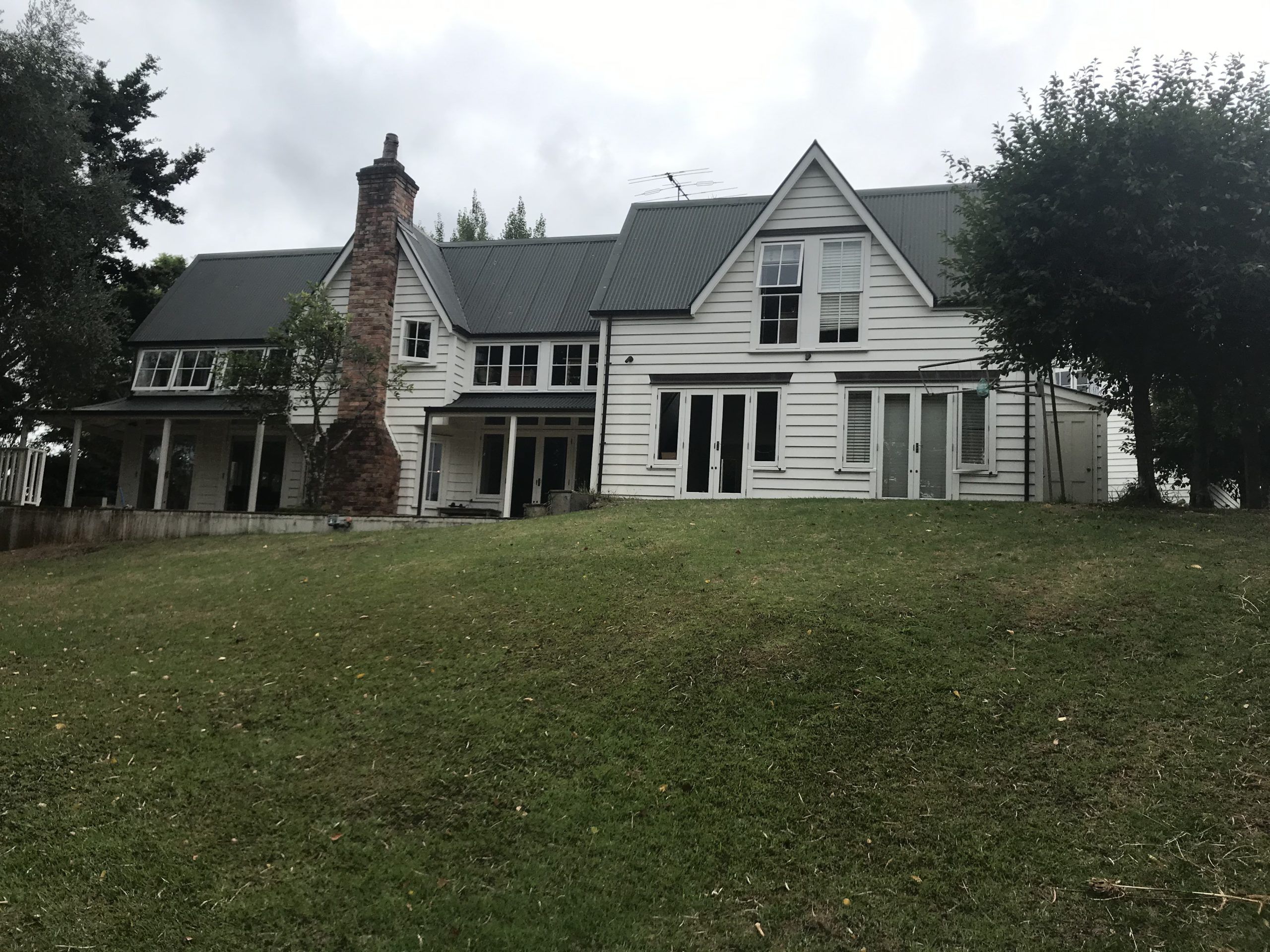
78 Orakei Road, Remuera
There has been a lot of neighbourhood activity recently around a proposed development at 78 Orakei Road, where a reported 172 year old house is to be demolished to make way for 19 townhouses.
Under the Auckland Unitary Plan, the property is zoned Mixed Housing Suburban which is the most widespread residential zone covering many established suburbs and some greenfields areas. Much of the existing development in the zone is characterised by one or two storey, mainly standalone buildings, set back from site boundaries with landscaped gardens. The zone enables intensification, while retaining a suburban built character. Development within the zone will generally be two storey detached and attached housing in a variety of types and sizes to provide housing choice. The primary objective of this is to increase “housing capacity, intensity and choice in the zone.” Demolition of buildings is a permitted activity. [1]
Much of Remuera is zoned Mixed Housing Suburban with some areas of Single House Zone on the northern slopes, with the higher density zones Mixed Housing Urban and Terrace Housing and Apartment Buildings along or in close proximity to Remuera Road. Some areas in the Single House Zone (formerly Residential 2) have the Special Character Area Overlay which can both discourage and enable development, e.g. Arney Road, Seaview Road, Ridings Road, and the upper reaches of Victoria Avenue and Orakei Roads.
This zoning was all finalised under the Auckland Unitary Plan process. But it started with Plan Change 163 which was notified in 2005 in response to increasing concern at the number of older houses being demolished in suburbs such as Herne Bay. Plan Change 163 sought to allow some control over demolition in the character areas (including Residential 1 and 2 Zones). The public and property owners had the opportunity to participate with submissions – some people took this opportunity, most did not.
Remuera Heritage (incorporated only in 2007) was able to participate in the subsequent appeal process as an interested party. In the appeal process, the council decided to pursue ‘a targeted approach’ to the evaluation of each property which required significant resources and investigation which the council appeared unable to support. Remuera Heritage, on examining the proposed mapping of properties, noticed that there was a high error rate in the verification of each property. Remuera Heritage undertook a comprehensive street analysis of every property in the Residential 2 Zone in Remuera. We took an impartial overview and did our best to alert Council and the Environment Court to the continually unacceptable level of inconsistency and error in the maps but were generally greeted with an inflexible response. Some property owners were also opposed to RH’s involvement. Some of these errors in the so-named demolition control maps were carried across to the Unitary Plan.
Hence a possible 172 year old house has no protection whatsoever, falling just outside the former Residential 2 Zone, and therefore not subject to the Plan Change 163 process of analysis. In fact, none of the houses in the lower part of Orakei Rd have any protection, since demolition is a permitted activity. No. 151 Orakei Road, Arlestone, is also zoned Mixed Housing Suburban for multi-units. There is one property, 79 Orakei Road, which is on the council’s historic heritage schedule. If a building is on the council’s Historic Heritage Schedule, demolition is not a permitted activity, although an application can still be made for demolition – unless it is Category A. However, these applications for consent will trigger an alert for the Orakei Local Board to request public notification, is this is deemed necessary, but there are no guarantees that the building will be safe from demolition.
Heritage New Zealand
There is a trigger for the Heritage New Zealand Pouhere Taonga Act 2014 if a property or site is pre-1900. Its Standard archaeological authority process says:
The Heritage New Zealand Pouhere Taonga Act 2014 makes it unlawful for any person to modify or destroy, or cause to be modified or destroyed, the whole or any part of an archaeological site without the prior authority of Heritage New Zealand. If you wish to do any work that may affect an archaeological site you must obtain an authority from Heritage New Zealand before you begin. [2]
If an application is made for demolition of a pre-1900 building (as this house is purported to be) then this will require an archaeological authority.
Under the Resource Management Act and the Auckland Unitary Plan, the reality is that public notification is rarely triggered under the Unitary Plan because of the zoning applied and the absence of the Special Character overlay in large parts of Remuera. There will be much more intensification in Remuera in both the Mixed Housing Suburban and the Mixed Housing Urban Zones. It can be seen already in Clonbern Road and St Vincent Avenue where many fine old villas have been demolished.
What can we do?
We can keep our ears and eyes open for heritage houses under threat and make it known to the Orakei Local Board, Auckland Councillor Desley Simpson, local MP David Seymour and list MP Paul Goldsmith, and of course to Remuera Heritage. Take photos of houses at risk, both from the exterior, and interior – if you can. We can ask the council to do research on the history of properties and evaluations of them to see if they meet the criteria for nomination to the council’s Historic Heritage Schedule. Remuera Heritage can also do some evaluations, but both require consent of the property owner for nomination. Mostly this is withheld as it is erroneously believed that this will affect future property values, when the reverse has been proven to apply, i.e. heritage houses sell for more money.
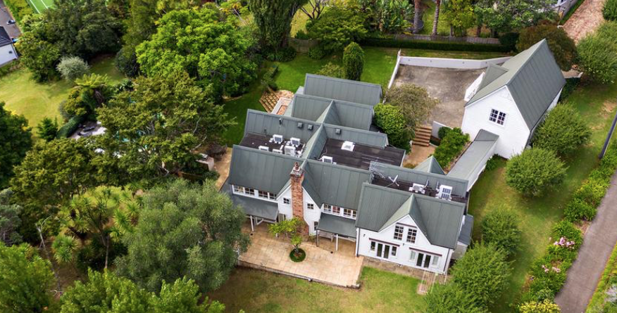
78 Orakei Road, Remuera, aerial view
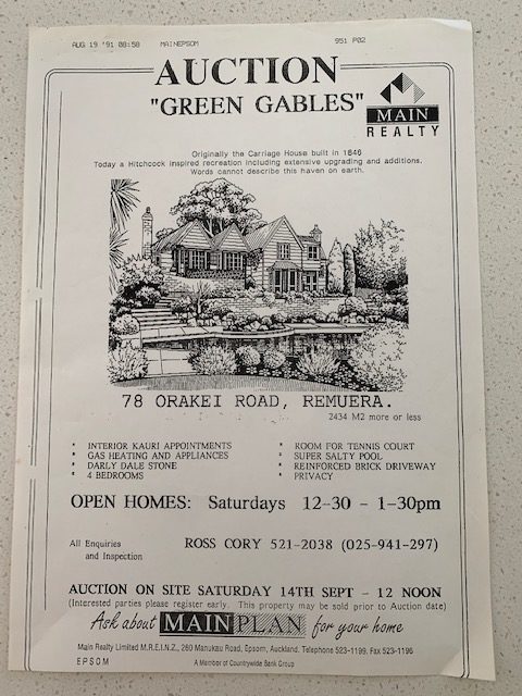
78 Orakei Road, Carriage House poster, House for Sale 19 August 1991
Subscribe to our newsletter to keep up to date.
[1] Auckland Council. H4. Residential – Mixed Housing Suburban Zone
[2] Heritage New Zealand. Standard archaeological process. https://www.heritage.org.nz/protecting-heritage/archaeology/standard-archaeological-authority-process
Related Stories
RETURN TO TOP
